- Benton County (Oregon)
-
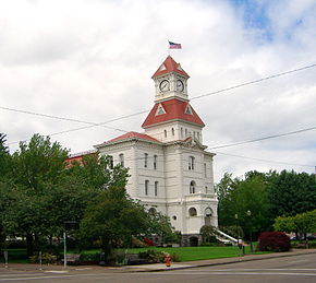
Verwaltung US-Bundesstaat: Oregon Verwaltungssitz: Corvallis Adresse des
Verwaltungssitzes:Benton County Courthouse
120 NW 4th Street
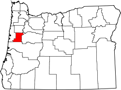
Corvallis, OR 97330Gründung: 1847 Gebildet aus: Polk County Vorwahl: 001 541 Demographie Einwohner: 78.153 (2000) Bevölkerungsdichte: 44,6 Einwohner/km² Geographie Fläche gesamt: 1.759 km² Wasserfläche: 6 km² Karte Website: www.co.benton.or.us Benton County[2] ist ein County im US-Bundesstaat Oregon der Vereinigten Staaten von Amerika. Bei der Volkszählung im Jahr 2000 hatte das County 78.153 Einwohner und eine Bevölkerungsdichte von 45 Einwohnern pro Quadratkilometer. Der Verwaltungssitz (County Seat) ist Corvallis.
Inhaltsverzeichnis
Geografie
Das County hat eine Fläche von 1.759 Quadratkilometern, wovon 6 Quadratkilometer Wasserflächen sind. Es grenzt im Süden an Lane County, im Osten an Linn County, im Westen an Lincoln County und im Norden an Polk County.
Demografische Daten
Historische Einwohnerzahlen Census Einwohner ± in % 1850 814 — 1860 3074 300 % 1870 4584 50 % 1880 6403 40 % 1890 8650 40 % 1900 6706 -20 % 1910 10.663 60 % 1920 13.744 30 % 1930 16.555 20 % 1940 18.629 10 % 1950 31.570 70 % 1960 39.165 20 % 1970 53.776 40 % 1980 68.211 30 % 1990 70.811 4 % 2000 78.153 10 % Vor 1900[3] Nach der Volkszählung im Jahr 2000 lebten im County 78.153 Menschen. Es gab 30.145 Haushalte und 18.237 Familien. Die Bevölkerungsdichte betrug 45 Einwohner pro Quadratkilometer. Ethnisch betrachtet setzte sich die Bevölkerung zusammen aus 89,16% Weißen, 0,84% Afroamerikanern, 0,79% amerikanischen Ureinwohnern, 4,49% Asiaten, 0,24% Bewohnern aus dem pazifischen Inselraum und 1,92% Prozent aus anderen ethnischen Gruppen; 2,56% stammten von zwei oder mehr ethnischen Gruppen ab. 4,66% der Bevölkerung waren spanischer oder lateinamerikanischer Abstammung.
Von den 30.145 Haushalten hatten 28,40% Kinder und Jugendliche unter 18 Jahre, die bei ihnen lebten. 50,40% waren verheiratete, zusammenlebende Paare, 7,20% waren allein erziehende Mütter. 39,50% waren keine Familien. 26,10% waren Singlehaushalte und in 6,70% lebten Menschen im Alter von 65 Jahren oder darüber. Die Durchschnittshaushaltsgröße betrug 2,43 und die durchschnittliche Familiengröße lag bei 2,95 Personen.
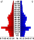
Auf das gesamte County bezogen setzte sich die Bevölkerung zusammen aus 21,30% Einwohnern unter 18 Jahren, 20,20% zwischen 18 und 24 Jahren, 26,70% zwischen 25 und 44 Jahren, 21,40% zwischen 45 und 64 Jahren und 10,30% waren 65 Jahre alt oder darüber. Das Durchschnittsalter betrug 31 Jahre. Auf 100 weibliche Personen kamen 99,10 männliche Personen, auf 100 Frauen im Alter ab 18 Jahren kamen statistisch 97,80 Männer.
Das jährliche Durchschnittseinkommen eines Haushalts betrug 41.897 USD, das Durchschnittseinkommen der Familien betrug 56.319 USD. Männer hatten ein Durchschnittseinkommen von 42.018 USD, Frauen 29.795 USD. Das Prokopfeinkommen betrug 21.868 USD. 14,60% der Bevölkerung und 6,80% der Familien lebten unterhalb der Armutsgrenze. 10,60% davon waren unter 18 Jahre und 4,90% waren 65 Jahre oder älter.
Städte und Ortschaften
- Adair Village
- Corvallis
- Monroe
- North Albany
- Philomath
Einzelnachweise
- ↑ Auszug aus dem National Register of Historic Places. Abgerufen am 13. März 2011
- ↑ Benton County im Geographic Names Information System des United States Geological Survey. Abgerufen am 22. Februar 2011
- ↑ U.S. Census Bureau _ Census of Population and Housing. Abgerufen am 28. Februar 2011
- ↑ Auszug aus Census.gov. Abgerufen am 28. Februar 2011
- ↑ Auszug aus factfinder.census.gov Abgerufen am 28. Februar 2011
Weblinks
Liste der Countys in Oregon
Baker | Benton | Clackamas | Clatsop | Columbia | Coos | Crook | Curry | Deschutes | Douglas | Gilliam | Grant | Harney | Hood River | Jackson | Jefferson | Josephine | Klamath | Lake | Lane | Lincoln | Linn | Malheur | Marion | Morrow | Multnomah | Polk | Sherman | Tillamook | Umatilla | Union | Wallowa | Wasco | Washington | Wheeler | Yamhill
Wikimedia Foundation.


