Bettyhill

Bettyhill
Bettyhill
Koordinaten 58° 32′ N, 4° 13′ W58.527222222222-4.2233333333333Koordinaten: 58° 32′ N, 4° 13′ W
Bettyhill (Schottland)
Bettyhill
Bettyhill
Verwaltung
Post town THURSO
Postleitzahlen­abschnitt KW14
Vorwahl 01641
Landesteil Scotland
Unitary authority Highland
Britisches Parlament Caithness, Sutherland and Easter Ross
Schottisches Parlament Caithness, Sutherland and Ross
Sandstrand
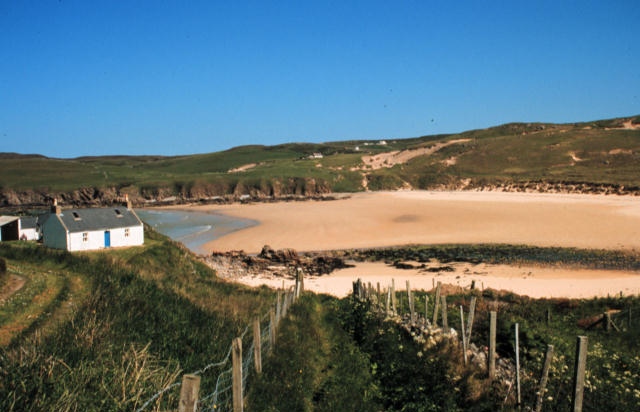
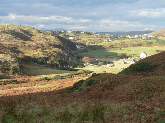
Bettyhill, von Osten aus gesehen

Bettyhill (gälisch Am Blàran Odhar) ist ein kleiner Ort in Nordschottland. Er wurde 1819 durch Elizabeth, Gräfin von Sutherland gegründet. Sie ließ diesen Ort damals als Ersatz für den Ort Rosal in Strathnaver, der geräumt werden musste, errichten und benannte ihn nach sich selbst.

Der ursprüngliche Ort wurde im Zuge der immer intensiveren Nutzung durch Schafherden aufgegeben. Diese Vorgangsweise war für die damalige Zeit der "Räumungen" durchaus ungewöhnlich. Man ging normalerweise nicht so zimperlich mit den Einheimischen um.

Weblinks

 Commons: Bettyhill – Sammlung von Bildern, Videos und Audiodateien

Wikimedia Foundation.

Игры ⚽ Нужен реферат?

Schlagen Sie auch in anderen Wörterbüchern nach:

  • Bettyhill — Coordinates: 58°32′N 4°13′W / 58.53°N 4.22°W / 58.53; 4.22 …   Wikipedia

  • Strathnaver — or Strath Naver (Scottish Gaelic, Srath Nabhair ) is the strath of the River Naver, in the Sutherland area of the Highland Highland of Scotland. The Strathnaver area is also known as Farr.The strath runs from AltnaharraOrdnance Survey grid… …   Wikipedia

  • List of bus routes in Scotland — List of bus routes in Scotland.{| class= wikitable border=1 cellspacing=0 cellpadding=4 Route Number Route Operator 1 Clermiston to Ocean Terminal, Leith Lothian Buses 2 Gyle Centre to The Jewel (Asda) Lothian Buses 3/3A Wester Hailes… …   Wikipedia

  • A836 road — The A836 road is entirely within the Highland area of Scotland, and 129 miles (208 km) long.It branches from the A9 near Tain and runs generally north through Bonar Bridge and Lairg, until Tongue. Between Lairg and Tongue the road is single track …   Wikipedia

  • Naver Athletic Camanachd Club — Naver Athletic Full name Naver Athletic Camanachd Club Gaelic name Comann Camanachd Nabhair Nickname The Cattachs Founded 2008 Ground Shinty Pitch, Bettyhill 2009 Defunct …   Wikipedia

  • Kinlochbervie — infobox UK place country = Scotland official name= Kinlochbervie gaelic name= Ceann Loch Biorbhaidh population = 480 (2001) os grid reference= latitude=58.46 longitude= 5.05 unitary scotland= Highland lieutenancy scotland= Sutherland constituency …   Wikipedia

  • Crask — Coordinates: 58°31′57″N 4°11′52″W / 58.53251°N 4.19764°W / 58.53251; 4.19764 …   Wikipedia

  • Scottish Highlands — The Scottish Highlands (Scottish Gaelic: A Ghàidhealtachd , Scots: Hielans ) include the rugged and mountainous regions of Scotland north and west of the Highland Boundary Fault, although the exact boundaries are not clearly defined, particularly …   Wikipedia

  • Highland (council area) — infobox Scotland council area Council= The Highland Council Sgire Comhairle na Gàidhealtachd SizeRank= 1st Size= 30,659 km² Water= ? AdminHQ= Inverness ISO= GB HLD ONS= 00QT PopulationRank= 7th PopulationDate= 2004 Population= 211,340… …   Wikipedia

  • List of museums in Scotland — This list of museums in Scotland contains museums which are defined for this context as institutions (including nonprofit organizations, government entities, and private businesses) that collect and care for objects of cultural, artistic,… …   Wikipedia

Share the article and excerpts

Direct link
Do a right-click on the link above
and select “Copy Link”