Bolimów

Bolimów
Bolimów
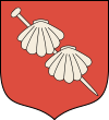
Wappen von Bolimów
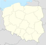
Bolimów (Polen)
Bolimów
Bolimów
Basisdaten
Staat: Polen
Woiwodschaft: Łódź
Landkreis: Skierniewice
Geographische Lage: 52° 4′ N, 20° 10′ O52.06666666666720.166666666667Koordinaten: 52° 4′ 0″ N, 20° 10′ 0″ O
Einwohner:

930 (2006)

Postleitzahl: 99-417
Telefonvorwahl: (+48) 46
Kfz-Kennzeichen: ESK
Wirtschaft und Verkehr
Straße: Skierniewice - Sochaczew
Nächster int. Flughafen: Łódź
Warschau
Gemeinde
Gemeindeart: Landgemeinde
Fläche: 112,2 km²
Einwohner:

4021
(31. Dez. 2010) [1]

Bevölkerungsdichte: 36 Einw./km²
Gemeindenummer (GUS): 1015012
Verwaltung (Stand: 2007)
Gemeindevorsteher: Stanisław Linart
Adresse: ul. Łowicka 9
99-417 Bolimów
Webpräsenz: www.bolimow.pl

Bolimów ist ein Dorf und Sitz der gleichnamigen Landgemeinde im Zentralen Polens, im Powiat Skierniewicki, Woiwodschaft Łódź. Bolimów liegt am Fluss Rawka und hat etwa 900 Einwohner.

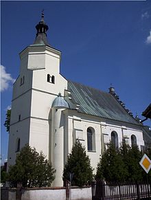
Kirche der Heiligen Anna

Inhaltsverzeichnis

Geschichte

Vom 1435 bis 1870 hatte das Dorf den Status einer Stadt.


Die Landgemeinde Bolimów hat eine Fläche von 112,21 km² und ungefähr 4.000 Einwohner.

Verweise

Weblinks

 Commons: Bolimów – Album mit Bildern und/oder Videos und Audiodateien

Fußnoten

  1. Population. Size and Structure by Territorial Division. As of December 31, 2010. Główny Urząd Statystyczny (GUS), abgerufen am 16. Juli 2011.

Wikimedia Foundation.

Игры ⚽ Нужно решить контрольную?

Schlagen Sie auch in anderen Wörterbüchern nach:

  • Bolimow — Bolimów …   Deutsch Wikipedia

  • Bolimów — Infobox Settlement name = Bolimów settlement type = Village total type = image shield = subdivision type = Country subdivision name = POL subdivision type1 = Voivodeship subdivision name1 = Łódź subdivision type2 = County subdivision name2 =… …   Wikipedia

  • Bolimow — Original name in latin Bolimw Name in other language Bolimow, Bolimuv, Bolimw, Болимув State code PL Continent/City Europe/Warsaw longitude 52.07671 latitude 20.16352 altitude 89 Population 930 Date 2010 10 16 …   Cities with a population over 1000 database

  • Bolimów Landscape Park — Infobox protected area name=Bolimów Landscape Park native name=Bolimowski Park Krajobrazowy iucn category = V caption= location=central Poland area=231.3 km² established=1986Bolimów Landscape Park ( Bolimowski Park Krajobrazowy ) is a protected… …   Wikipedia

  • Gmina Bolimów — Infobox Settlement name = Gmina Bolimów other name = Bolimów Commune settlement type = Gmina total type = Total image shield = POL Bolimów COA.svg subdivision type = Country subdivision name = POL subdivision type1 = Voivodeship subdivision name1 …   Wikipedia

  • Nowe Kęszyce —   Village   …   Wikipedia

  • Battle of Bolimov — Infobox Military Conflict conflict = Battle of Bolimov partof = the Eastern Front during World War I caption = Eastern Front, 1915. date = January 31, 1915 place = near Bolimów, Poland result = Inconclusive combatant1 = flag|German Empire… …   Wikipedia

  • Bolimowska Wieś — Infobox Settlement name = Bolimowska Wieś settlement type = Village total type = image shield = subdivision type = Country subdivision name = POL subdivision type1 = Voivodeship subdivision name1 = Łódź subdivision type2 = County subdivision… …   Wikipedia

  • Łasieczniki — Infobox Settlement name = Łasieczniki settlement type = Village total type = image shield = subdivision type = Country subdivision name = POL subdivision type1 = Voivodeship subdivision name1 = Łódź subdivision type2 = County subdivision name2 =… …   Wikipedia

  • Sierzchów, Łódź Voivodeship — Infobox Settlement name = Sierzchów settlement type = Village total type = image shield = subdivision type = Country subdivision name = POL subdivision type1 = Voivodeship subdivision name1 = Łódź subdivision type2 = County subdivision name2 =… …   Wikipedia

Share the article and excerpts

Direct link
Do a right-click on the link above
and select “Copy Link”