Brixworth

Brixworth
52.3293-0.90378999999999
Brixworth (Vereinigtes Königreich)
Brixworth
Brixworth

Brixworth ist ein Dorf und ein Verwaltungsbezirk im Daventry district des Northamptonshire Countys in England. 2001 wurde eine Bevölkerung von 5162 gezählt[1].

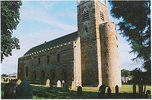
Die All Saints' Church aus dem 7. Jahrhundert

Das Dorf befindet sich rund 8 km nördlich von Northampton, an der A508. Östlich des Dorfes befindet sich der künstliche See Pitsford Reservoir. Im Ort steht eine der ältesten, größten und am besten erhaltensten angelsächsischen Kirchen des Landes, die etwa im Jahr 680 fertiggestellte All Saints' Church. Aufgrund der zentralen Lage ist Brixworth Wohnort vieler Pendler, die in London oder Birmingham arbeiten. Durch die Nähe zu den Autobahnen M1, M6 und M14 bietet Brixworth gute Verkehrsanbindung. Des Weiteren befindet sich der Ort in der Nähe der Städte Peterborough und Leicester.

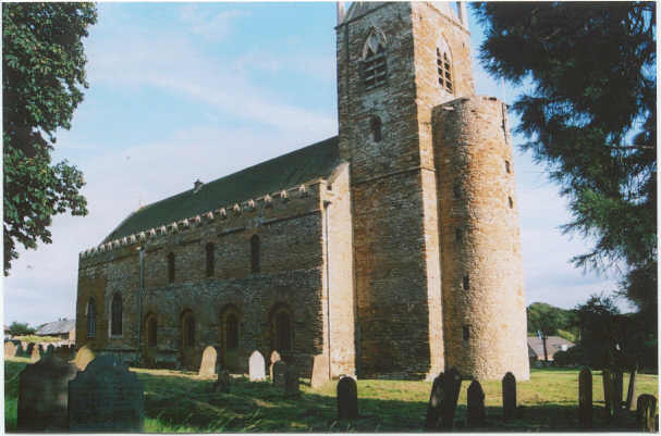
Historisch war die Gegend um Brixworth für Eisenerz-Steinbrüche bekannt, die von diversen Güterzuglinien versorgt wurden. Heute beheimatet die ländliche Gegend um Brixworth einige High-Tech-Unternehmen, darunter Ilmor Engineering und Mercedes-Benz HighPerformanceEngines. Teile des Turmgemäuers der All Saints' Kirche werden von einer speziellen Stahl-Spannleiste fixiert, die von Ilmor Engineering entwickelt und gestiftet wurde.

In Brixworth existiert ein Fußballverein namens Brixworth Juniors Football Club.

Weblinks

 Commons: Brixworth – Sammlung von Bildern, Videos und Audiodateien

Einzelnachweise

  1. ONS statistics

Wikimedia Foundation.

Игры ⚽ Нужно сделать НИР?

Schlagen Sie auch in anderen Wörterbüchern nach:

  • Brixworth — Infobox UK place country = England official name= Brixworth latitude= 52.32930 longitude= 0.90379 civil parish= Brixworth population = 5,162 (2001 Census) shire district= Daventry district shire county= Northamptonshire region= East Midlands… …   Wikipedia

  • Brixworth — Original name in latin Brixworth Name in other language Brixworth State code GB Continent/City Europe/London longitude 52.32912 latitude 0.9035 altitude 125 Population 5277 Date 2011 03 03 …   Cities with a population over 1000 database

  • Brixworth Country Park — lies next to Pitsford Water in Northamptonshire. Opened in 1997 it includes cycle hire, cafeteria and WCs. The site has easy access to the 7.5 mile footpath/cyclepath that circumnavigates the water, as well as bird watching facilities and picnic… …   Wikipedia

  • Brixworth Rural District — infobox historic subdivision Name= Brixworth RD HQ= Brixworth Status= Rural district Start= 1894 End= 1974 Replace= Daventry district The Brixworth Rural District was a rural district in Northamptonshire, England from 1894 to 1974,. It was named… …   Wikipedia

  • All Saints' Church, Brixworth — All Saints Church, Brixworth, showing Anglo Saxon work and spire Coordinates …   Wikipedia

  • Bishop of Brixworth — The Bishop of Brixworth is an episcopal title given to a suffragan bishop in the Church of England Diocese of Peterborough, which is within the Province of Canterbury, England. [ Crockford s Clerical Directory 2008/2009 (100th edition) , Church… …   Wikipedia

  • Northampton to Market Harborough line — [v · d · …   Wikipedia

  • Melton Mowbray North railway station — Melton Mowbray North Location Place Melton Mowbray Area Leicestershire Grid reference …   Wikipedia

  • Northamptonshire — Coordinates: 52°17′N 0°50′W / 52.283°N 0.833°W / 52.283; 0.833 …   Wikipedia

  • Daventry (district) — Daventry District   District   Shown within Northamptonshire Sovereign state …   Wikipedia

Share the article and excerpts

Direct link
Do a right-click on the link above
and select “Copy Link”