Brownsea Island

Brownsea Island

Vorlage:Infobox Insel/Wartung/Bild fehltVorlage:Infobox Insel/Wartung/Höhe fehlt

Brownsea Island
Gewässer Poole Harbour
Geographische Lage 50° 41′ 30″ N, 1° 58′ 20″ W50.691666666667-1.9722222222222Koordinaten: 50° 41′ 30″ N, 1° 58′ 20″ W
Brownsea Island (England)
Brownsea Island
Länge 2,4 km
Breite 1,2 km
Fläche 2,02 km²
Gedenkstein zur Gründung der Pfadfinderbewegung

Brownsea Island liegt in der Hafeneinfahrt von Poole Harbour. Es ist ein großer Naturhafen bei Poole, im Süden Großbritanniens. Die kleine Insel kann innerhalb von 2 Stunden umwandert werden. Sie steht unter Naturschutz, weil sie neben der Isle of Man der letzte Lebensraum des Roten Eichhörnchens in England ist.

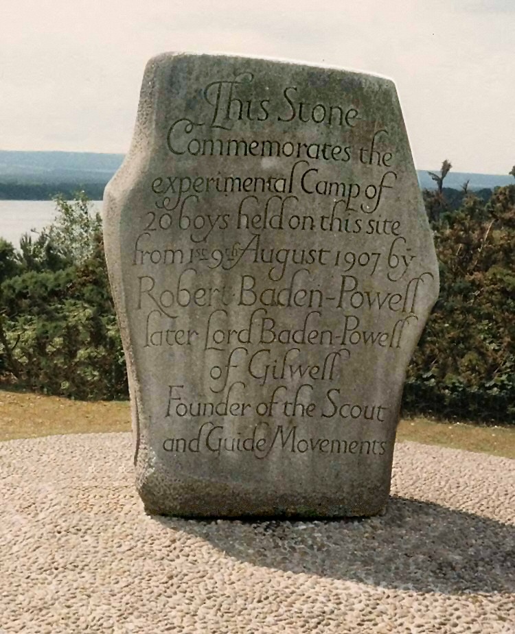
Auf dieser Insel fand vom 25. Juli bis 9. August 1907 das erste Probelager der Pfadfinder mit 21 Jungen, durchgeführt von Robert Baden-Powell, statt.[1] Baden-Powell reiste einige Tage vor den 21 Jungen an, um das Lager vorzubereiten. Die Jungen, die in vier Patrols eingeteilt wurden, trafen am 30. Juli 1907 ein und an diesem Abend fand das erste Lagerfeuer statt, und der Morgen des 1. August 1907 gilt als der Beginn der Pfadfinderbewegung.

Die Insel ist durch Tiden bedroht, die Land nach und nach abtragen. Sie ist außerdem ein beliebtes Touristenziel, weil auf ihr neben den bereits erwähnten Roten Eichhörnchen auch noch Pfaue, Fasane und Rotwild leben.

Es ist nur den Mitgliedern der zwei Weltpfadfinderbünde World Organization of the Scout Movement und World Association of Girl Guides and Girl Scouts gestattet, auf Brownsea Island zu übernachten, alle anderen Besucher müssen die Insel mit der letzten Fähre um 18:00 Uhr verlassen. Auf der Insel darf kein Feuer gemacht werden, da sie ein großes Torfvorkommen besitzt.

Auf Brownsea befindet sich ein altes Fort und wenige alte Wohnhäuser sowie die Reste einer Tonbrennerei.

Quellen

  1. Johnny Walker: Brownsea and its significance - The world's first Scout Camp. In: Scouting Milestones. Februar 2006

Weblinks

 Commons: Brownsea Island – Sammlung von Bildern, Videos und Audiodateien

Wikimedia Foundation.

Игры ⚽ Нужно решить контрольную?

Schlagen Sie auch in anderen Wörterbüchern nach:

  • Brownsea Island — infobox UK place country= England official name= Brownsea Island latitude= 50.690 longitude= 1.971 civil parish= shire district= Purbeck shire county= Dorset region= South West England constituency westminster=South Dorset post town= POOLE… …   Wikipedia

  • Brownsea Island — 50° 41′ 24″ N 1° 58′ 16″ W / 50.69, 1.971 Brownsea Island est la plus gran …   Wikipédia en Français

  • Brownsea Island Ferries Ltd — is a company that operates ferries to Brownsea Island in Poole Harbour from Poole and Sandbanks. It also operates cruises around Poole Harbour. Vessels operated by the company are Maid of Poole , Maid of the Harbour , Maid of the Lakelands and… …   Wikipedia

  • Brownsea Island Scout camp — infobox WorldScouting | type = campsite | | name = Brownsea Island Scout camp | location = Poole Harbour | country = England | f date = 1 August 1907 | founder = Robert Baden Powell | owner = National Trust lat degrees =50| lat minutes =41| lat… …   Wikipedia

  • Brownsea — Island Brownsea Island est la plus grande des huit îles de Poole Harbour, Dorset (Angleterre). La plus grande partie est une réserve naturelle et un important habitat d oiseaux. L île est ouverte au public mais le flux de visiteurs est régulé.… …   Wikipédia en Français

  • Brownsea Open Air Theatre — (commonly abbreviated B.O.A.T) is a theatre company in Poole, Dorset that has performed large scale theatrical projects since 1964. Annually performing a play from the extensive works of William Shakespeare for three weeks in July and August, the …   Wikipedia

  • Brownsea — Recorded in many spellings including Brownsea, Brownsie, Brownsey, Browncey, Bransey, Bronsey, and probably others, this is an English surname. It is locational and almost certainly from Brownsea Island which guards the entrance to the famous… …   Surnames reference

  • Île de Brownsea — Brownsea Island Brownsea Island est la plus grande des huit îles de Poole Harbour, Dorset (Angleterre). La plus grande partie est une réserve naturelle et un important habitat d oiseaux. L île est ouverte au public mais le flux de visiteurs est… …   Wikipédia en Français

  • Furzey Island — infobox UK place country = England official name= Furzey Island latitude= 50.682527 longitude= 1.98372 map type=Dorset civil parish=Corfe Castle shire district= Purbeck shire county= Dorset region= South West England constituency… …   Wikipedia

  • Green Island (Dorset) — infobox UK place country = England official name= Green Island latitude= 50.67893 longitude= 1.990799 map type=Dorset civil parish=Corfe Castle shire district= Purbeck shire county= Dorset region= South West England constituency westminster=South …   Wikipedia

Share the article and excerpts

Direct link
Do a right-click on the link above
and select “Copy Link”