- Albertopolis
-
Albertopolis ist der Spitzname einer Gegend in South Kensington die sich zwischen der Cromwell Road und dem Kensington Gore befindet und zahlreiche Kultur- und Bildungsstätten umfasst. Sie wird daher auch Museum Mile genannt.
Inhaltsverzeichnis
Geschichte
Das Gelände wurde von der für die „Great Exhibition“ von 1851 zuständigen Regierungskommission von den erwirtschafteten Überschüssen der Ausstellung erworben. An diese Ausstellung erinnert der Name der durch das Gelände verlaufenden Exhibition Road. Prinz Albert war eine der treibenden Kräfte hinter der Londoner Industrieausstellung und Präsident der verantwortlichen Regierungskommission. Die Bezeichnung „Albertopolis“ scheint in der 1850er Jahren geprägt worden zu sein, um sein Rolle im Kulturleben des Viktorianischen Zeitalters sowohl zu ehren, als auch zu verspotten. Nach seinem Tod wurde der Begriff ungebräuchlich und das Gelände im allgemeinen als South Kensington bezeichnet.
Die Bezeichnung „Albertopolis“ wurde in den 1960er Jahren durch Bauhistoriker wiederbelebt. Im Rahmen der beginnenden Denkmalpflege wurde die Bezeichnung „Albertopolis“ popularisiert, um die Aufmerksamkeit der Öffentlichkeit auf den viktorianischen Gebäudekomplex zu lenken, der durch Erweiterungs- und Sanierungspläne des Imperial College vom Abriss bedroht war.
Gebäude und Einrichtungen
- Imperial College London
- Natural History Museum
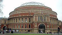
- Royal Albert Hall
- Royal College of Art
- Royal College of Music
- Royal Geographical Society
- Science Museum
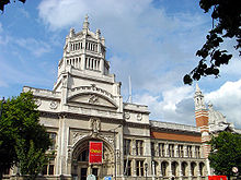
- Victoria and Albert Museum
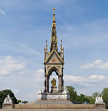
- Albert Memorial
Ehemals eigenständige Institutionen:
- Geological Museum, heute Bestandteil des Natural History Museum
- Royal School of Mines, heute Bestandteil des Imperial College
Nicht mehr bestehenden Institutionen:
- Royal College of Organists (von 1904 bis 1991)
- Royal School of Naval Architecture (von 1864 bis 1873)
- Royal School of Needlework (von 1903 bis 1987)
- Imperial Institute (von 1893 bis 1962)
Nachweise
- F. H. W. Sheppard (Hrsg.): Survey of London: volume 38: South Kensington Museums Area. Athlone Press for the Greater London Council, 1975
Weiterführende Literatur
- John Physick: Albertopolis: The estate of the 1851 Commissioners. In: Chris Brooks (Hrsg.): The Albert Memorial: The Prince Consort national memorial: its history, contexts and conservation. Yale University Press, New Haven (CT) 2000, S. 308–338, ISBN 0300073119
Weblinks
- Victoria and Albert Museum walking tour of Albertopolis (Englisch)
- Royal Commission for the Exhibition of 1851 (Englisch)
- Albertopolis, online exhibition Architektur und Geschichte (Englisch)
Wikimedia Foundation.


