- Amphoe Pathum Rat
-
Pathum Rat
ปทุมรัตต์Provinz: Roi Et Fläche: 356,9 km² Einwohner: 52.744 (2005) Bev.dichte: 147,8 E./km² PLZ: 45190 Geocode: 4503 Karte 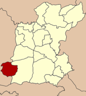
Amphoe Pathum Rat (Thai: อำเภอ ปทุมรัตต์) ist ein Landkreis (Amphoe - Verwaltungs-Distrikt) im Südwesten der Provinz Roi Et. Die Provinz Roi Et liegt im Isaan, der Nordostregion von Thailand.
Inhaltsverzeichnis
Geographie
Amphoe Pathum Rat grenzt an die folgenden Landkreise (von Osten im Uhrzeigersinn): an Amphoe Kaset Wisai in der Provinz Roi Et, sowie an die Amphoe Phayakkhaphum Phisai, Na Dun und Wapi Pathum der Provinz Maha Sarakham.
Geschichte
Pathum Rat wurde am 15. Juni 1963 zunächst als Kleinbezirk (King Amphoe) eingerichtet, indem die drei Tambon Bua Daeng, Phon Sung und Non Sawan vom Amphoe Kaset Wisai abgetrennt wurden.[1] Am 27. Juli 1965 wurde er zum Amphoe heraufgestuft.[2]
Verwaltungseinheiten
Amphoe Pathum Rat ist in acht Gemeinden (Tambon) gegliedert, die wiederum in 98 Dorfgemeinschaften (Muban) unterteilt sind.
Es gibt eine Kleinstadt (Thesaban Tambon) im Landkreis:
- Pathum Rat (Thai: เทศบาลตำบลปทุมรัตต์), bestehend aus Teilen der Tambon Bua Daeng und Non Sa-nga.
Daneben gibt es acht Tambon-Verwaltungs-Organisationen („Tambon Administrative Organizations“ - TAO, Thai: องค์การบริหารส่วนตำบล).
Nr. Name Thai Dörfer Einw. 1. Bua Daeng บัวแดง 11 7.699 2. Dok Lam ดอกล้ำ 15 7.620 3. Nong Khaen หนองแคน 14 7.754 4. Phon Sung โพนสูง 9 5.069 5. Non Sawan โนนสวรรค์ 16 6.780 6. Sa Bua สระบัว 17 7.670 7. Non Sa-nga โนนสง่า 8 5.400 8. Khilek ขี้เหล็ก 8 4.752 Einzelnachweise
- ↑ ประกาศกระทรวงมหาดไทย เรื่อง แบ่งท้องที่การปกครองอำเภอเกษตรวิสัยตั้งเป็นกิ่งอำเภอ. In: Royal Gazette. 80, Nr. 59 ง, 11. Juni 1963, S. 1507.
- ↑ พระราชกฤษฎีกาตั้งอำเภอศรีสวัสดิ์ อำเภอสังขละบุรี อำเภอท่าคันโท อำเภอดอกคำใต้ อำเภอแม่ใจ อำเภอจุน อำเภอขามทะเลสอ อำเภอไพศาลี อำเภอท่าวังผา อำเภอบ้านกรวด อำเภอเด่นชัย อำเภอปทุมรัตต์ อำเภอกะเปอร์ อำเภออากาศอำนวย อำเภอดอนเจดีย์ อำเภอจอมพระ และอำเภอสามโก้ พ.ศ. ๒๕๐๘. In: Royal Gazette. 81, Nr. 49 ก, 27. Juli 1965, S. 565–569.
Weblinks
- Weitere Informationen über Amphoe Phathum Rat von amphoe.com (in thailändischer Sprache)

Amphoe: Mueang Roi Et | Kaset Wisai | Pathum Rat | Chaturaphak Phiman | Thawat Buri | Phanom Phrai | Phon Thong | Pho Chai | Nong Phok | Selaphum | Suwannaphum | Mueang Suang | Phon Sai | At Samat | Moei Wadi | Si Somdet | Changhan | Chiang Khwan | Nong Hi | Thung Khao Luang


Wikimedia Foundation.