- Amphoe Si Somdet
-
Si Somdet
ศรีสมเด็จProvinz: Roi Et Fläche: 217,43 km² Einwohner: 37.161 (2005) Bev.dichte: 170,9 E./km² PLZ: 45000 Geocode: 4516 Karte 
Amphoe Si Somdet (Thai: อำเภอ ศรีสมเด็จ) ist ein Landkreis (Amphoe - Verwaltungs-Distrikt) in der Provinz Roi Et. Die Provinz Roi Et liegt im Isaan, der Nordostregion von Thailand.
Inhaltsverzeichnis
Geographie
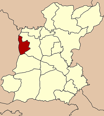
Amphoe Si Somdet grenzt an die folgenden Landkreise (von Norden im Uhrzeigersinn): an die Amphoe Mueang Roi Et und Chaturaphak Phiman in der Provinz Roi Et, sowie an die Amphoe Wapi Pathum, Kae Dam und Mueang Maha Sarakham der Provinz Maha Sarakham.
Geschichte
Si Somdet wurde am 1. April 1987 zunächst als Kleinbezirk (King Amphoe) eingerichtet, indem die fünf Tambon Pho Thong, Si Somdet, Mueang Plueai, Nong Yai und Suan Chik vom Amphoe Mueang Roi Et abgetrennt wurden.[1] Am 4. Juli 1994 wurde er zum Amphoe heraufgestuft.[2]
Verwaltungseinheiten
Amphoe Si Somdet ist in acht Gemeinden (Tambon) gegliedert, die wiederum in 852 Dorfgemeinschaften (Muban) unterteilt sind.
Daneben gibt es acht Tambon-Verwaltungs-Organisationen („Tambon Administrative Organizations“ - TAO, Thai: องค์การบริหารส่วนตำบล).
Nr. Name Thai Dörfer Einw. 1. Pho Thong โพธิ์ทอง 7 2.877 2. Si Somdet ศรีสมเด็จ 13 6.079 3. Mueang Plueai เมืองเปลือย 8 3.075 4. Nong Yai หนองใหญ่ 10 3.883 5. Suan Chik สวนจิก 14 5.447 6. Phosai โพธิ์สัย 10 8.043 7. Nong Waeng Khuang หนองแวงควง 12 4.926 8. Ban Bak บ้านบาก 8 2.831 Einzelnachweise
- ↑ ประกาศกระทรวงมหาดไทย เรื่อง แบ่งเขตท้องที่อำเภอเมืองร้อยเอ็ด จังหวัดร้อยเอ็ด ตั้งเป็นกิ่งอำเภอศรีสมเด็จ. In: Royal Gazette. 104, Nr. 67 ง, 9. April 1987, S. 2483.
- ↑ พระราชกฤษฎีกาตั้งอำเภอเปือยน้อย ... และอำเภอศรีวิไล พ.ศ. ๒๕๓๗. In: Royal Gazette. 111, Nr. 21 ก, 3. Juni 1994, S. 32–35.
Weblinks
- Weitere Informationen über Amphoe Si Somdet von amphoe.com (in thailändischer Sprache)

Amphoe: Mueang Roi Et | Kaset Wisai | Pathum Rat | Chaturaphak Phiman | Thawat Buri | Phanom Phrai | Phon Thong | Pho Chai | Nong Phok | Selaphum | Suwannaphum | Mueang Suang | Phon Sai | At Samat | Moei Wadi | Si Somdet | Changhan | Chiang Khwan | Nong Hi | Thung Khao Luang

Wikimedia Foundation.