Armadale (Western Australia)
- Armadale (Western Australia)
-
Armadale ist eine Stadt mit etwa 12.000 Einwohnern im australischen Bundesstaat Western Australia. Sie befindet sich 27 Kilometer südöstlich vom Zentrum der Hauptstadt Perth und liegt damit am Rand der Metropolregion. Im Zentrum von Armadale treffen sich zwei Hauptverbindungsstraßen, der South Western und der Albany Highway, die den Süden des Bundesstaats mit Perth verbinden. Armadale ist der Sitz des gleichnamigen Verwaltungsgebiet (LGA) City of Armadale.
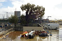
Im Zentrum der Stadt befindet sich ein ungewöhnlich großer und alter Eucalyptus marginata-Baum, der Old Jarrah Tree. Sein Alter wird auf 400 bis 800 Jahre geschätzt. Aufgrund der extensiven Forstwirtschaft und Abholzung in der Gegend um Perth im 19.Jahrhundert, sind solche Bäume selten.
Weblinks
Einzelnachweise
- ↑ Australian Bureau of Statistics (25. Oktober 2007): Armadale (State Suburb) (Englisch). 2006 Census QuickStats. Abgerufen am 9. Januar 2011.
Wikimedia Foundation.
Schlagen Sie auch in anderen Wörterbüchern nach:
Armadale, Western Australia — Infobox Australian Place | type = suburb name = Armadale city = Perth state = wa caption = lga = City of Armadale postcode = 6112 pop = 12,019 (2006 census) area = 8 est = propval = $295,000 (Q1 2007) cite web|url=http://reiwa.com/res/res iframe… … Wikipedia
Kelmscott, Western Australia — Infobox Australian Place | type = suburb name = Kelmscott city = Perth state = wa caption = lga = City of Armadale postcode = 6111 pop = 9,417 (2006 census) area = 15.9 est = propval = $333,000 (Q1 2007) cite web|url=http://reiwa.com/res/res… … Wikipedia
Brookdale, Western Australia — Infobox Australian Place | type = suburb name = Brookdale city = Perth state = wa caption = lga = City of Armadale postcode = 6112 est = 1997 pop = 2,656 (2006 Census) area = 10.0 propval = $276,525 (Q4 2006)cite web|url=http://reiwa.com/res/res… … Wikipedia
Atwell, Western Australia — Infobox Australian Place | type = suburb name = Atwell city = Perth state = wa caption = Old farm building at northern entrance to Atwell lga = City of Cockburn postcode = 6164 est = pop = 6928 (2006 census)Census 2006 AUS|id=SSC51061|name=Atwell … Wikipedia
Roleystone, Western Australia — Infobox Australian Place | type = suburb name = Roleystone city = Perth state = wa caption = lga = City of Armadale area = 12.2 postcode= 6111 pop = 5,975 (2006 census) dist1 = 30 | dir1 = SE | location1=Perth dist2 = 8 | dir2 = NE |… … Wikipedia
Forrestdale, Western Australia — Infobox Australian Place | type = suburb name = Forrestdale city = Perth state = wa caption = lga = City of Armadale postcode = 6112 pop = 1,297 (2006 census) area = 49.5 est = propval = $381,000 cite web|url=http://reiwa.com/res/res iframe… … Wikipedia
Westfield, Western Australia — Infobox Australian Place | type = suburb name = Westfield city = Perth state = wa caption = lga = City of Armadale postcode = 6111 pop = 4,523 (2006 census) area = 2.5 est = propval = $283,000 (Q1 2007) cite web|url=http://reiwa.com/res/res… … Wikipedia
Perth, Western Australia — Perth, Australia redirects here. For the town in Tasmania, see Perth, Tasmania. For other uses, see Perth (disambiguation) and Perth, Western Australia (disambiguation). Perth Western Australia … Wikipedia
Wungong, Western Australia — Infobox Australian Place | type = suburb name = Wungong city = Perth state = wa caption = lga = City of Armadale postcode = 6112 pop = 600 (2006 census) area = 4.3 est = propval = stategov = Armadale fedgov = Canning dist1 = 32 location1= Perth… … Wikipedia
Bedfordale, Western Australia — Infobox Australian Place | type = suburb name = Bedfordale city = Perth state = wa caption = lga = City of Armadale postcode = 6112 pop = 1,830 (2006 census) area = 49 est = propval = $561,500 (Q1 2007) cite web|url=http://reiwa.com/res/res… … Wikipedia
 Australien
 Western Australia

 Old Jarrah Tree

