- Atchafalaya River
-
Atchafalaya River 
Verlauf des Flusses
Daten Lage Louisiana, USA Flusssystem Mississippi River Ursprung aus dem Mississippi bei der Einmündung des Red River
31° 1′ 12″ N, 91° 44′ 53″ W31.0199026-91.7481753Mündung bei Morgan City in die Atchafalaya Bay des Golfs von Mexiko 29.4793823-91.2737176Koordinaten: 29° 28′ 46″ N, 91° 16′ 25″ W
29° 28′ 46″ N, 91° 16′ 25″ W29.4793823-91.2737176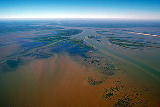
Delta des Flusses
Der Atchafalaya River ist ein Mündungsarm des Mississippi River und des Red River. Er ist ungefähr 270 km lang und befindet sich im mittleren Süden Louisianas in den Vereinigten Staaten. Er ist schiffbar und wird als Industrieschifffahrtskanal für den Bundesstaat Louisiana genutzt. Der Atchafalaya River bildet das kulturelle Herz des Cajun Countrys. Die Instandhaltung des Flusses als schiffbarer Arm des Mississippis ist seit mehr als einem Jahrhundert ein Hauptprojekt der United States Army Corps of Engineers.
Der Atchafalaya River entsteht bei Simmesport am Zusammenfluss von Red und Mississippi River, wo der Mississippi mit dem Red River über den 11 km langen, kanalisierten Old River verbunden ist. Er erhält Wasser aus dem Red und dem Mississippi River, der selbst in seinem Hauptarm weiter nach Südosten verläuft. Er mäandriert südwärts durch den Kanal des Mississippi, durch ausgedehnte Deiche und Flussauen, durch Morgan City und fließt in den Golf von Mexiko in die Atchafalaya Bay ungefähr 25 km südlich von Morgan City. Der Fluss bildet gerade ein neues Delta in der Bucht – der einzige Bereich an Louisianas Küste, in dem neues Land entsteht.
Inhaltsverzeichnis
Namensvarianten
Der Fluss besitzt mehrere Bezeichnungsvarianten:
- Atachafalaya River[1]
- Atachaffalaya River[2]
- Atchaalaya River[2]
- Atchafalayia River[2]
- Atchafayalia River[2]
- Atchafaylia River[2]
- Atchaffalay River[3]
- Atchafylia River[2]
- Atchapalaya River[2]
- Bayou Atchafalaya[4]
- Chafalia River[5]
- Chaffalia River[5]
- Chaffeli River[6]
- River Atchafa-Laya[5]
- Tchafalaya River[5]
Einzelnachweise
- ↑ GNIS - US Post Office Site Location Report, 1837-1950, available in microfilm, use code US-T140/# - # of roll. roll 245
- ↑ a b c d e f g GNIS - US Post Office Site Location Report, 1837-1950, available in microfilm, use code US-T140/# - # of roll. roll 237
- ↑ Original township survey plats, published in the 1800's. 1827
- ↑ Lorio, Elaine C. The Place-Names of Pointe Coupee Parish. Baton Rouge, Louisiana: Louisiana State University Thesis, 1932. p10
- ↑ a b c d Read, William Alexander Louisiana Place-Names of Indian Origin Baton Rouge, Louisiana. Louisiana State University Press, 1927. p5
- ↑ Saucier, Corinne L. History of Avoyelles Parish, Louisiana. New Orleans, Louisiana: Pelican Publishing Company, 1943. p198
Siehe auch
Weblinks
Kategorien:- Fluss in Louisiana
- Fluss in Nordamerika
- Flusssystem Mississippi River

Wikimedia Foundation.