Bagunte

Bagunte
Bagunte
Wappen Karte
Das Wappen fehlt noch Lagekarte für Bagunte
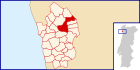
Basisdaten
Region: Norte
Unterregion: Grande Porto
Distrikt: Porto
Concelho: Vila do Conde
Koordinaten: 41° 22′ N, 8° 40′ W41.371503-8.661578Koordinaten: 41° 22′ N, 8° 40′ W
Einwohner: 1.662 (Stand: 2001)
Fläche: 9,2 km²
Bevölkerungsdichte: 181 Einwohner pro km²
Politik
Adresse der Gemeindeverwaltung: Junta de Freguesia de Bagunte
Rua da Igreja, 98
4480-214 Bagunte
Webseite: www.jf-bagunte.pt

Vorlage:Infobox Ort in Portugal/Wartung/Art ist leer

Vorlage:Infobox Ort in Portugal/Wartung/Karte ist ausgefüllt


Vorlage:Infobox Ort in Portugal/Wartung/Höhe ist leer Vorlage:Infobox Ort in Portugal/Wartung/PLZ ist leer Vorlage:Infobox Ort in Portugal/Wartung/Bürgermeister ist leer


Vorlage:Infobox Ort in Portugal/Wartung/Email ist leer

Bagunte ist eine Gemeinde im Nordwesten Portugals.

Bagunte gehört zum Kreis Vila do Conde im Distrikt Porto, besitzt eine Fläche von 9,2 km² und hat 1.662 Einwohner (Stand: 2001).[1]

Archäologische Fundstätte

  • Cividade de Bagunte

Einzelnachweise

  1. Daten zu Bagunte. alea.pt, abgerufen am 8. Juni 2011 (englisch).

Weblinks


Wikimedia Foundation.

Игры ⚽ Поможем написать курсовую

Schlagen Sie auch in anderen Wörterbüchern nach:

  • Castros Du Portugal — Les castros sont des fortifications résidentielles de la fin de l âge du bronze et caractéristiques de l âge du fer. Dans la péninsule ibérique en général, et à l intérieur du Portugal aussi, suivant leur localisation ils appartiennent à des… …   Wikipédia en Français

  • Castros du Portugal — Les castros sont des fortifications résidentielles de la fin de l âge du bronze et caractéristiques de l âge du fer. Dans la péninsule Ibérique en général, et à l intérieur du Portugal aussi, suivant leur localisation, ils appartiennent à des… …   Wikipédia en Français

  • Castros du portugal — Les castros sont des fortifications résidentielles de la fin de l âge du bronze et caractéristiques de l âge du fer. Dans la péninsule ibérique en général, et à l intérieur du Portugal aussi, suivant leur localisation ils appartiennent à des… …   Wikipédia en Français

  • Monuments of Portugal — The Monuments of Portugal were constructed throughout the Portuguese territory, and date back to the period of pre historic settlement of occupation. Subsequently, the region that is today Portugal has been colonized by many civilizations, which… …   Wikipedia

  • Vila do Conde — Géolocalisation sur la carte : Portugal …   Wikipédia en Français

  • Vila do conde — Vila do Conde …   Wikipédia en Français

  • Районы округа Порту — …   Википедия

  • Багунте — Посёлок Багунте Bagunte Страна ПортугалияПортугалия …   Википедия

  • Vila do Conde — (pron. IPA2| vilɐ du kõd(ɨ)) is a city and parish in Portugal with a population of 25,731. Together with the urban parishes of Azurara and Arvore the urban area of the city has 32,094 in the estuary of the Ave river, in the north of Oporto… …   Wikipedia

  • List of postal codes in Portugal — Aveiro districtMealhada municipality*3050 Antes *3050 Barcouço *3050 Casal Comba *3050 Luso *3050 Mealhada *3050 Pampilhosa *3050 Vacariça *3050 Ventosa do BairroMurtosa municipality*3870 Bunheiro *3870 Monte *3870 Murtosa *3870 TorreiraOliveira… …   Wikipedia

Share the article and excerpts

Direct link
Do a right-click on the link above
and select “Copy Link”