Bellsund

Bellsund
77.66666666666714
Bellsund (Svalbard und Jan Mayen)
Bellsund
Bellsund

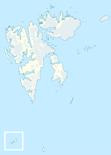
Der Bellsund ist – dem Namen nach – ein Sund in Spitzbergen auf Svalbard. Genauer wäre aber die Bezeichnung als Eingang eines größeren Fjordsystems auf der Westseite der Insel Spitzbergen. Die Ostseite mündet in die Grönlandsee, die Westseite teilt sich in zwei große Fjorde auf, den Van Mijenfjorden im Norden, der von der Insel Akseløja abgegrenzt wird, und den südlichen, der sich wiederum in zwei Fjorde, den größeren, östlichen Van Keulenfjorden und den kurzen Recherchefjorden aufteilt.

Im Norden des Bellsund liegt die Halbinsel Nordenskiöld Land, im Süden liegt Wedel Jarlsberg Land.

Der Name Bellsund leitet sich vom Klokkefjellet ab, einem glockenförmigen Berg am Eingang des Bellsund. Klokke (norwegisch) und Bell (englisch) bedeuten beide Glocke. Auf fast allen Karten seit dem Beginn des 17. Jahrhunderts wurde eine Variante dieses Namens verwendet − entsprechend den frühen, unkoordinierten Kartographierungen in Svalbard (siehe dazu den Hauptartikel Spitzbergen) − in verschiedenen Sprachen und Formen.

Literatur und Quellen


Wikimedia Foundation.

Игры ⚽ Нужно решить контрольную?

Schlagen Sie auch in anderen Wörterbüchern nach:

  • Bellsund — is a 20 km long sound on the west coast of Spitsbergen, part of the Svalbard archipelago.HistoryBellsund was first seen by William Barents in 1596. He simply referred to it as Inwyck (inlet). In 1610 Jonas Poole explored Bellsund, giving the… …   Wikipedia

  • Jonas Poole — (d. 1612) was an early 17th century English explorer, sealer, and whaler.Voyages to Bear Island, 1604 1609He served aboard vessels sent by the Muscovy Company on sealing voyages to Bear Island in 1604, 1605, 1606, 1608, and 1609. In 1607 he was… …   Wikipedia

  • Jonas Poole — (bautizado en 1566 a 1612)[1] fue un temprano [èxploración geográfica|explorador]], ballenero y foquero Inglés del siglo XVII. Aunque Henry Hudson ha sido a menudo llamado el «padre de la caza de ballenas inglesa» [ father of English whaling ],… …   Wikipedia Español

  • Nordenskiöld-Land-Nationalpark — Bellsund …   Deutsch Wikipedia

  • Nordenskiöld Land — Ansicht im Süden der Halbinsel (Nationalpark) Gewässer 1 Isfjorden Gewässer 2 …   Deutsch Wikipedia

  • Van Mijenfjorden — 77.790906915.5452224 Koordinaten: 77° 47′ N, 15° 33′ O …   Deutsch Wikipedia

  • Svalbard — For other uses, see Svalbard (disambiguation). Svalbard Flag …   Wikipedia

  • Geography of Svalbard — Location:Northern Europe, islands between the Arctic Ocean, Barents Sea, Greenland Sea, and Norwegian Sea, north of NorwayGeographic coordinates:Map references: Arctic RegionArea: total: 62,049 km² land: 62,049 km² water: 0 km² note: includes… …   Wikipedia

  • Spitsbergen — This article is about the island. For the archipelago of which it is a part, see Svalbard. Spitsbergen Map of Svalbard with Spitsbergen in the west emphasised Geography Location Arctic Ocean …   Wikipedia

  • Van Mijenfjorden — is the third longest fjord in Norway s Svalbard archipelago. It lies in the southern portion of Spitsbergen island. The fjord is 83 km long, entering the island from Bellsund in the west, south of Nordenskiöld Land. The settlement of Sveagruva… …   Wikipedia

Share the article and excerpts

Direct link
Do a right-click on the link above
and select “Copy Link”