Boulby

Boulby
Boulby
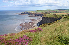
Steilküste bei Boulby
Koordinaten 54° 34′ N, 0° 50′ W54.56059-0.827Koordinaten: 54° 34′ N, 0° 50′ W
Boulby (England)
Boulby
Boulby
Verwaltung
Post town SALTBURN-BY-THE-SEA
Postleitzahlen­abschnitt TS13
Landesteil England
Region North East England
Shire county Redcar and Cleveland
District Redcar and Cleveland

Boulby ist ein Dorf an der Nordseeküste der North York Moors in Redcar and Cleveland, Nordostengland. Nahe Boulby befindet sich die mit 203 Metern höchste Steilküste Englands, wirtschaftlich waren immer verschiedene Arten des Bergbaus von Bedeutung.

Boulby entstand vermutlich, da sich in den Kliffs Alaun befindet, das spätestens seit dem frühen Mittelalter an der gesamten Küste der North York Moors abgebaut wurde. Im Domesday Book ist Boulby als Bolebi oder Bollebi aufgeführt.[1] In der Zeit des Ersten Weltkriegs nutzte die britische Armee das Territorium: In Boulby steht ein knapp sechs Meter hohes Hohlspiegelmikrofon aus verstärktem Beton, das ankommende Schiffe der deutschen Marine antizipieren sollte.[2]

Das Alaun wurde anfangs noch im Tagebau direkt aus den Kliffs gefördert, später aus Tunneln, die in die Kliffs hineingetrieben wurden.[3] Nachdem die Tunnel lange Zeit verschüttet waren, hat die Erosion sie in den 1990ern teilweise wieder freigelegt.[4] Es handelt sich dabei um die besterhaltene Alaun-Mine der Gegend, die als Ancient Scheduled Monument geschützt ist.[5] Touristisch profitiert das Dorf aber vor allem von den Steilküsten und der spektakulären Aussicht dort. Unter anderem führt der National Trail Cleveland Way an Boulby vorbei.[3] Wirtschaftlich bedeutsam für die Gegend ist auch die Cleveland Potash Mine, auch oft Boulby Mine genannt, die seit den 1970er Jahren Kaliumcarbonat fördert. Dort ist auch das Boulby Underground Laboratory untergebracht, wo physikalische Experimente durchgeführt werden.

Die Mine in Boulby ist mit einer Güterverbindung an das nationale Eisenbahnnetz angeschlossen.[6]

Weblinks

Anmerkungen

  1. Domesday Book im National Archive
  2. Boulby Sound Mirror
  3. a b eskvalley.com: Boulby
  4. Hidden Teesside: Boulby Alum Tunnel
  5. Teesarcheology: Alum
  6. Paddy Dilon: Cleveland Way: With Yorkshire Wolds Way and Link, Cicerone Press Limited, 2005, ISBN 1852844477, S. 143.

Wikimedia Foundation.

Игры ⚽ Поможем написать курсовую

Schlagen Sie auch in anderen Wörterbüchern nach:

  • Boulby — Infobox UK place country = England latitude = 54.560590 longitude = 0.827000 official name = Boulby static static image caption = population = civil parish = unitary england = Redcar and Cleveland region = North East England lieutenancy england …   Wikipedia

  • Boulby Mine — Surface workings at Boulby Mine Gemmy, sharp green blue boracite cryst …   Wikipedia

  • Boulby Quarries — Geobox Protected Area name = Boulby Quarries native name = other name = other name1 = category local = Site of Special Scientific Interest category iucn = image size = image caption = country = England region = North East region type = Region… …   Wikipedia

  • Boulby Underground Laboratory — Das Boulby Underground Laboratory ist eine unterirdische Versuchsstation für Experimente der Teilchenphysik. Es ist nahe Whitby in der Boulby Mine, der tiefsten Mine Englands, untergebracht. Das Labor liegt 1100 m unter dem Erdboden, dies… …   Deutsch Wikipedia

  • Charles Hubert Boulby Blount — Air Vice Marshal Charles Hubert Boulby Blount CB OBE MC (26 October 1893 23 October 1940) was an English soldier, airman and first class cricketer. His great great nephew is singer James Blunt (né James Hillier Blount). Contents 1 Family 2… …   Wikipedia

  • Cleveland Potash Mine — Cleveland Potash Ltd. Tagesanlagen der Boulby Mine Rechtsfor …   Deutsch Wikipedia

  • North York Moors — Heide , Farn und Weidelandschaft der North York Moors Die North York Moors sind eine Hochebene in North Yorkshire im Nordosten Englands. Das 1436 km² große, südöstlich von Middlesbrough direkt an der Nordsee gelegene Gebiet erhebt sich etwa… …   Deutsch Wikipedia

  • Esk Valley Line — The Esk Valley Line is the railway line from Middlesbrough to Whitby in North Yorkshire, England. The route follows the course of the River Esk for much of its eastern half.It was designated as a community rail line in July 2005, being one of… …   Wikipedia

  • Whitby Redcar and Middlesbrough Union Railway — The Whitby, Redcar and Middlesbrough Union Railway (WRMU) was a short lived railway line, running along the North east coast of England from the River Tees at Middlesbrough to the Esk at Whitby, where it met the Scarborough Whitby Railway line… …   Wikipedia

  • Directional Recoil Identification From Tracks — The DRIFT IIb Detector removed from the vacuum vessel for maintenance. The Directional Recoil Identification From Tracks (DRIFT) detector is a low pressure negative ion time projection chamber (NITPC) designed to detect weakly interacting massive …   Wikipedia

Share the article and excerpts

Direct link
Do a right-click on the link above
and select “Copy Link”