- Calumpit
-
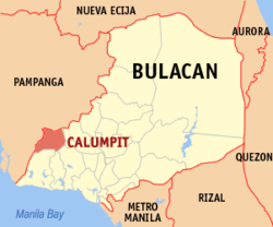
Municipality of Calumpit Lage von Calumpit in der Provinz Bulacan Basisdaten Bezirk: Central Luzon Provinz: Bulacan Barangays: 29 Distrikt: 1. Distrikt von Bulacan PSGC: 031407000 Einkommensklasse: 1. Einkommensklasse Haushalte: 16.167 Zensus 1. Mai 2000Einwohnerzahl: 98.017 Zensus 1. August 2007Koordinaten: 14° 55′ N, 120° 46′ O14.916120.766Koordinaten: 14° 55′ N, 120° 46′ O Geographische Lage auf den Philippinen Calumpit ist eine Stadtgemeinde in der philippinischen Provinz Bulacan. Im Jahre 2000 zählte sie 82.113 Einwohner und 16.167 Haushalte. Im Westen grenzt Calumpit an die Provinz Pampanga.
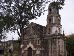
In der Stadtgemeinde befindet sich auch die älteste Kirche von Bulacan. Die St. John the Baptist Church wurde 1572 erbaut. Der Augustiner Diego Vivar-Ordonez beaufsichtigte den Bau der Kirche. Innerhalb der Kirche befindet sich ein Tunnel, der einer Legende nach von Priestern während des spanischen Regimes verwendet wurde, um Gold, Statuen und Schmucksachen vor den Schatzräubern zu verstecken.
Baranggays
Calumpit ist in folgende 29 Baranggays aufgeteilt:
- Balite
- Balungao
- Buguion
- Bulusan
- Calizon
- Calumpang
- Caniogan
- Corazon
- Frances
- Gatbuca
- Gugo
- Iba Este
- Iba O'Este
- Longos
- Meysulao
- Meyto
- Palimbang
- Panducot
- Pio Cruzcosa
- Poblacion
- Pungo
- San Jose
- San Marcos
- San Miguel
- Santa Lucia
- Santo Niño
- Sapang Bayan
- Sergio Bayan
- Sucol
Städte und Stadtgemeinden in der Provinz BulacanStädte: Malolos | San Jose del Monte
Stadtgemeinden:
Angat | Balagtas | Baliuag | Bocaue | Bulacan | Bustos | Calumpit | Doña Remedios Trinidad | Guiguinto | Hagonoy | Marilao | Meycauayan | Norzagaray | Obando | Pandi | Paombong | Plaridel | Pulilan | San Ildefonso | San Miguel | San Rafael | Santa Maria
Wikimedia Foundation.
Schlagen Sie auch in anderen Wörterbüchern nach:
Calumpit — Saltar a navegación, búsqueda REPUBLICA DE FILIPINAS Provincia de Bulacán Municipio de Calumpit Imagen La iglesia parroquial de San Juan Bautista. Mapa … Wikipedia Español
Calumpit — Original name in latin Calumpit Name in other language Calumpit State code PH Continent/City Asia/Manila longitude 14.91639 latitude 120.76583 altitude 9 Population 91815 Date 2011 07 31 … Cities with a population over 1000 database
Calumpit, Bulacan — Infobox Philippine municipality infoboxtitle = Bayan ng Calumpit, Bulacan sealfile = Ph seal bulacan calumpit.png locatormapfile = Ph locator bulacan calumpit.png caption = Map of Bulacan showing the location of Calumpit region = Central Luzon… … Wikipedia
calumpit — variant of kalumpit … Useful english dictionary
Bulacan — This article is about the province. For the municipality, see Bulacan, Bulacan. For the river, see Bulacan River. For the barangay, see Hindang, Leyte; Looc, Occidental Mindoro; Mabini, Batangas; Malalag, Davao del Sur; Payao, Zamboanga Sibugay;… … Wikipedia
Schlacht um die Philippinen — Teil von: Zweiter Weltkrieg, Pazifikkrieg Gebiet der Philippinen … Deutsch Wikipedia
Roberto Pagdanganan — Roberto M. Pagdanganan Philippine Tourism Secretary In office February 2004 – September 2005 President Gloria Macapagal Arroyo … Wikipedia
Malolos City — This article is about the city. For the cathedral, see Malolos Cathedral. For the barangay, see Barili, Cebu or Malinao, AlbayInfobox Settlement official name = City of Malolos other name = Li Han (ancient Chinese name) native name = Lungsod ng… … Wikipedia
Malolos — This article is about the city. For the cathedral, see Malolos Cathedral. For the barangay, see Barili, Cebu or Malinao, Albay City of Malolos Lungsod ng Malolos Urban Component City … Wikipedia
Leticia' s Garden Private Resort — (Calumpit,Филиппины) Категория отеля: 1 звездочный отель Адрес … Каталог отелей