Carrowmore Lake

Carrowmore Lake
Carrowmore Lake
Loch na Ceathru Moire
Am Westufer
Am Westufer
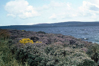
Geographische Lage County Mayo (Irland)
Zuflüsse Carrowmore River
Abfluss Owenmore River
Inseln mehrere
Daten
Koordinaten 54° 0′ 0″ N, 9° 42′ 0″ W54-9.7Koordinaten: 54° 0′ 0″ N, 9° 42′ 0″ W
Carrowmore LakeLoch na Ceathru Moire (Irland)
Carrowmore LakeLoch na Ceathru Moire

Carrowmore Lake (irisch Loch na Ceathru Moire) ist ein See im County Mayo, Provinz Connacht in der Republik Irland. Der See liegt zwischen den Orten Bangor Erris und Barnatra am Südende der Broadhaven Bay der Irischen See.

Inhaltsverzeichnis

Allgemeines

Carrowmore Lake ist ein Süßwasser-See, hat einen Maximaldurchmesser von rund 5 km und ist von Bergland umgeben. Der See ist nicht sehr tief, liefert aber für die ganze Region Erris auf der Mullet-Halbinsel das Trinkwasser. Die Ufer sind von einem Moor-Gürtel umgeben, trotzdem gibt es eine nicht unerhebliche Anzahl von Wohnhäusern entlang der Moorgebiete. Das Wassereinzugsgebiet des Sees reicht bis in die Region von Kilcommon, wo sich die wichtige Corrib-Gas-Raffinerie befindet, die das natürliche Erdgasvorkommen vor der Küste fördert und verarbeitet.

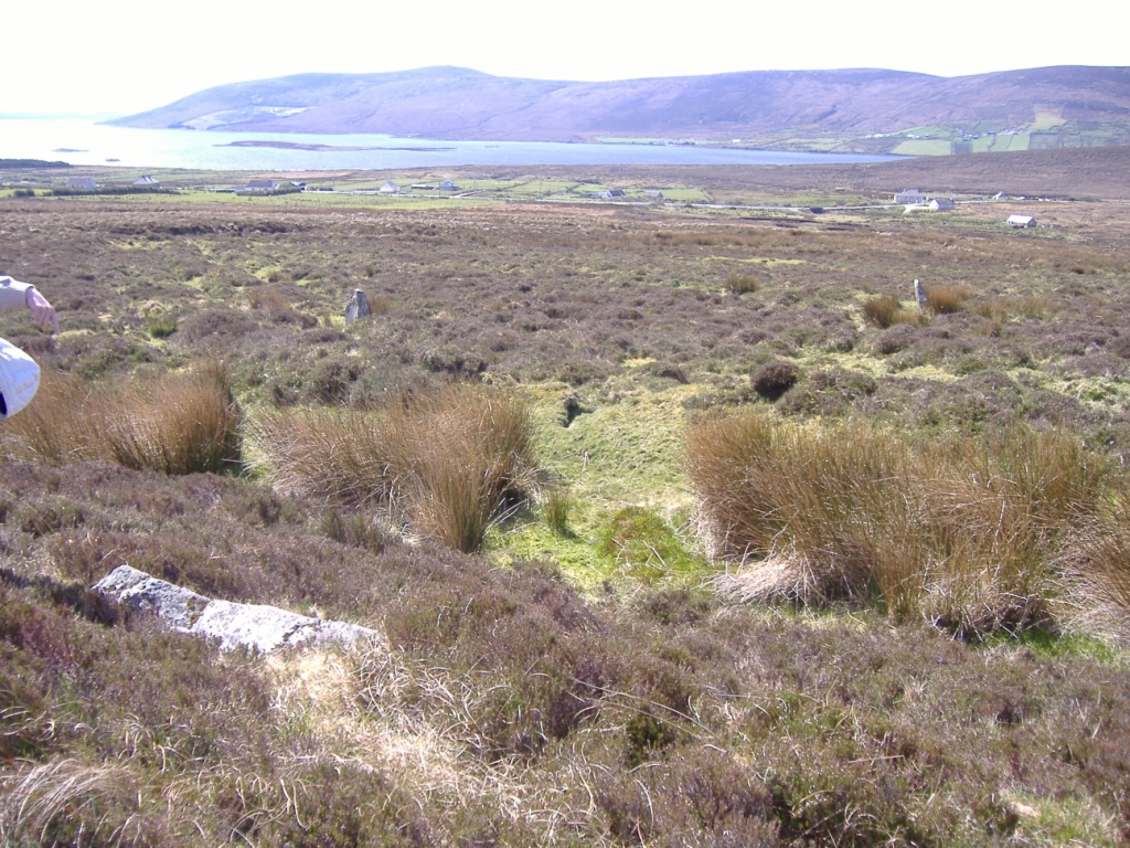
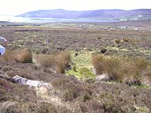
Blick vom Norden mit zwei prähistorischen Menhiren in der Bildmitte

Ein Gedicht von George William Russell über den Carrowmore Lake[1] befindet sich im Archiv der National Library of Ireland.

Archäologie

Einige der Inseln im See sind crannogs (künstliche Inseln), die als Befestigungsanlagen von der Eisenzeit bis ins 17. Jahrhundert dienten. Das Bergfort Rathmorgan (Iorras Domhnann) auf einem Berg am Südwestufer des Carrowmore Lake soll die in der Sage Táin Bó Flidhais („Das Wegtreiben von Flidhais' Rindern“) genannte Burg Dún Flidhais sein.

Carrowmore Lake darf nicht mit dem ebenfalls archäologisch wichtigem Gebiet Carrowmore im County Sligo verwechselt werden.

Weblinks

Einzelnachweise

  1. Text des Gedichtes

Wikimedia Foundation.

Игры ⚽ Нужен реферат?

Schlagen Sie auch in anderen Wörterbüchern nach:

  • Carrowmore — Lageplan Carrowmore und …   Deutsch Wikipedia

  • Táin Bó Flidhais — Queen Medb, Myths Legends of the Celtic Race (1911) T.W.Rolleston Táin Bó Flidhais, also known as the Mayo Táin, is a tale from the Ulster Cycle of early Irish literature. It is one of a group of works known as Táin Bó, or cattle raid stories,… …   Wikipedia

  • County Mayo — For other uses, see Mayo (disambiguation). County Mayo Contae Mhaigh Eo Coat of arms …   Wikipedia

  • Belmullet — Béal an Mhuirthead   Town   Belmullet square on Heritage day …   Wikipedia

  • Bangor Erris — Infobox Irish Place name = Bangor Erris gaeilge = Beannchar crest motto = map pin coords = left: 45px; top: 33px north coord = 54.1431 | west coord = 9.7403 | irish grid = F863229 area = | elevation = 96 m province = Connacht county = County Mayo …   Wikipedia

  • Shell to Sea — Chaîne humaine de gardaí pour bloquer l entrée de la raffinerie aux manifestants (novembre 2007). Shell to Sea en anglais ou Shell chun Sáile en irlandais (littéralement Le coquillage / l entreprise Shell à la mer) est un mouvement d opposition à …   Wikipédia en Français

  • Táin Bó Flidhais — („Das Wegtreiben von Flidais Rindern“), auch Táin Bó Flidais oder Mayo Táin, ist der Titel einer Erzählung aus dem Ulster Zyklus der Irischen Mythologie. Überliefert ist eine altirische, aber kürzere und eine etwas längere Version aus dem… …   Deutsch Wikipedia

  • Sligo — /sluy goh/, n. 1. a county in Connaught province, in the NW Republic of Ireland. 55,425; 694 sq. mi. (1795 sq. km). 2. its county seat: a seaport. 18,609. * * * ▪ Ireland Irish  Sligeach (“Shelly River”)        seaport and county seat, County… …   Universalium

  • Mullanacre Upper — is a townland in the Parish of Tomregan, Barony of Tullyhaw, County Cavan, Ireland. The townland name is an anglicisation of the Gaelic placename “Mullagh an Acre” which means ‘The acre of the summit’. In the 17th century it formed part of… …   Wikipedia

  • Anthropology and Archaeology — ▪ 2009 Introduction Anthropology       Among the key developments in 2008 in the field of physical anthropology was the discovery by a large interdisciplinary team of Spanish and American scientists in northern Spain of a partial mandible (lower… …   Universalium

Share the article and excerpts

Direct link
Do a right-click on the link above
and select “Copy Link”