Càrn Eige

Càrn Eige

pd5

Càrn Eige
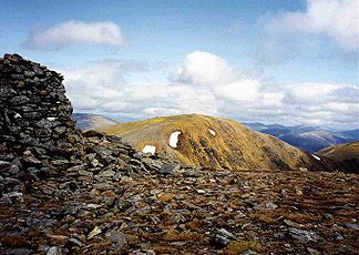
Blick auf den Càrn Eige vom großen Steinmännchen auf dem Mam Sodhail.

Blick auf den Càrn Eige vom großen Steinmännchen auf dem Mam Sodhail.

Höhe 1.183 m ASL
Lage Glen Affric, Highland, Schottland
Gebirge Cairngorms
Schartenhöhe 1.148 mfd2
Geographische Lage 57° 17′ 18″ N, 5° 6′ 51″ W57.288438-5.1140531183Koordinaten: 57° 17′ 18″ N, 5° 6′ 51″ W
Càrn Eige (Schottland)
Càrn Eige
Typ Marilyn

Der Càrn Eige, manchmal auch Càrn Eighe geschrieben ist der höchste Berg im nördlichen Schottland, nördlich des Great Glen. Er liegt in der Unitary Authority Highland auf der Grenze zwischen den Area Committees Inverness und Ross and Cromarty, im früheren Gebiet des Chisholm Clans.

Der Berg ist sehr abgelegen, etwa 10 km von der nächsten größeren Straße. Allerdings gibt es in Glen Affric eine Jugendherberge, die etwas näher liegt. In Bezug auf seine topographische Prominenz von 1148 m nimmt der Berg nach dem Ben Nevis den zweiten Rang auf den Britischen Inseln ein.

Weblinks

 Commons: Càrn Eige – Sammlung von Bildern, Videos und Audiodateien

Wikimedia Foundation.

Игры ⚽ Нужен реферат?

Schlagen Sie auch in anderen Wörterbüchern nach:

  • Càrn Eige — seen from the large cairn on Mam Sodhail. Elevation …   Wikipedia

  • Càrn Eige — vu depuis le cairn du Mam Sodhail. Géographie Altitude 1 183 m Massif Highlands …   Wikipédia en Français

  • Càrn Eige — Saltar a navegación, búsqueda Càrn Eige Elevación 1.183 msnm Ubicación …   Wikipedia Español

  • Carn Eige — Sp Kárn Egas Ap Carn Eige angliškai, geliškai (škotiškai) L k. Jungtinėje Karalystėje (Škotijoje) …   Pasaulio vietovardžiai. Internetinė duomenų bazė

  • Càrn Mòr — Elevation 829 m (2,720 ft) Prominence 613 m (2,011 ft) [ …   Wikipedia

  • Mam Sodhail — seen from Càrn Eige, 1 km to the NE. Elevation 1,181 m (3 …   Wikipedia

  • List of Munros — Infobox Mountain Name = Sections of Munro s tables Photo = Scotland sections of Munro s tables.png Caption = The approximate divisions of Scotland used in Munro s tables Elevation = over 3,000 feet (914.4 metres) Location = SCO Range = Prominence …   Wikipedia

  • Beinn a' Ghlò — Beinn a’ Ghlò Bràigh Coire Chruinn bhalgain (left) and Càrn nan Gabhar (right) seen from Càrn Liath. Elevation …   Wikipedia

  • Liathach — Spidean a Choire Léith Looking west along Liathach Elevation 1,055 m (3,461 ft) …   Wikipedia

  • Ciste Dhubh — seen from the Corbett Am Bàthach, three km to the south. Elevation …   Wikipedia

Share the article and excerpts

Direct link
Do a right-click on the link above
and select “Copy Link”