- Derwonaji
-
9.833333333333343.033333333333Koordinaten: 9° 50′ N, 43° 2′ O
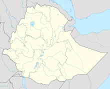

Derwonaji Derwonaji (auch Darwanaji,[1] Dher Wanaje,[2] Derwernache[3]) ist ein Ort in der Woreda Awbere in der Jijiga-Zone der Somali-Region in Äthiopien.
Nach Angaben der Zentralen Statistikagentur Äthiopiens für 2005 hatte Derwonaji 35.645 Einwohner.[4] 1997 waren von 23.891 Einwohnern 67,47 % einheimische Somali, 31,02 % waren Ausländer aus Somalia.[5]
1991 wurde in Derwonaji ein Flüchtlingslager für Flüchtlinge aus Nordsomalia/Somaliland eingerichtet. Die Bewohner gehörten größtenteils dem Clan der Gadabursi-Dir an und waren vor Kämpfen zwischen der SNM und lokalen Milizen um Boorama geflohen. Das Lager beherbergte aber auch Jidwaq- und Ogadeni-Darod und Angehörige der Gaboye-Minderheit, zudem waren etliche äthiopische Somali unter den Bewohnern. Durch Überprüfungen der Bewohner und die Rückkehr von Somaliern sank die Einwohnerzahl von anfangs über 100.000 auf unter 40.000 Mitte 1994, Ende 1998 waren es noch rund 27.000.[1] Am 30. Juni 2001 konnte das Lager geschlossen werden.[6]
Quellen
- ↑ a b Guido Ambroso: Pastoral society and transnational refugees: population movements in Somaliland and eastern Ethiopia 1988 - 2000. New Issues in Refugee Research, Working Paper No. 65, UNHCR – Evaluation and Policy Analysis Unit, 2002 (PDF)
- ↑ Ahmed Yusuf Farah, Emergencies Unit for Ethiopia (UN-EUE) Development Programme: Major Characteristics of the Ethiopian Somali Region, 1995
- ↑ Nordiska Afrikainstitutet: Local History of Ethiopia (PDF)
- ↑ Central Statistical Agency: 2005 National Statistics, Section–B Population, Table B.4 (PDF)
- ↑ The 1994 Population and Housing Census of Ethiopia: Results for Somali Region, Volume I: Part I. Statistical Report on Population Size and Charateristics, 1998 (PDF)
- ↑ UNHCR Mid-Year Progress Report 2001 - Ethiopia, 1. September 2001.

Wikimedia Foundation.