Cape Meares

Cape Meares
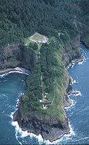
Luftaufnahme des Kaps
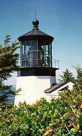
Der Leuchtturm am Kap Meares

Kap Meares (engl. Cape Meares) ist ein Kap an der Pazifikküste in Nordwest-Oregon (Pazifischer Nordwesten) in den Vereinigten Staaten. Es befindet sich am südlichen Ende der Bucht Tillamook Bay, ca. 8 km nordwestlich der Stadt Tillamook. Ein Großteil des Kaps wurde durch den Staat Oregon als Cape Meares State Scenic Viewpoint als Staatspark ausgewiesen und ein Teil des Kaps ist als Cape Meares National Wildlife Refuge auch unter Verwaltung des U.S. Fish & Wildlife Service. Das Kap ist ein beliebtes Aussichtsziel zum Beobachten von Vögeln und von Walen.

Leuchtturm

Der mit knapp 13 m Höhe kleinste Leuchtturm Oregons ging 1890 in Betrieb. Die Fresnel-Linse für den Leuchtturm wurde in Paris gefertigt und um das Kap Hoorn herum nach Oregon verschifft, wo sie dann vom Schiff über die Klippen hinweg auf das Kap gehievt wurde. Ab 1934 stand für den Leuchtturm Elektrizität zur Verfügung, 1963 wurde er schließlich stillgelegt. 1993 wurde er in die Denkmalschutzliste National Register of Historic Places aufgenommen.

Cape Meares wurde nach dem britischen Seefahrer John Meares benannt, dem ersten Europäer, der die Tillamook Bay erkundete.

Weblinks

(Jeweils Engl.)

45.469878-123.9689017Koordinaten: 45° 28′ 12″ N, 123° 58′ 8″ W


Wikimedia Foundation.

Игры ⚽ Поможем написать курсовую

Schlagen Sie auch in anderen Wörterbüchern nach:

  • Cape Meares — is a small headland on the Pacific coast of northwest Oregon in the United States. The cape forms a high steep bluff on the south end of Tillamook Bay, approximately 5 mi (8 km) northwest of the town of Tillamook. Much of the cape is part of Cape …   Wikipedia

  • Cape Meares — Cape Meares, OR U.S. Census Designated Place in Oregon Population (2000): 110 Housing Units (2000): 156 Land area (2000): 2.837498 sq. miles (7.349087 sq. km) Water area (2000): 0.262964 sq. miles (0.681074 sq. km) Total area (2000): 3.100462 sq …   StarDict's U.S. Gazetteer Places

  • Cape Meares, OR — U.S. Census Designated Place in Oregon Population (2000): 110 Housing Units (2000): 156 Land area (2000): 2.837498 sq. miles (7.349087 sq. km) Water area (2000): 0.262964 sq. miles (0.681074 sq. km) Total area (2000): 3.100462 sq. miles (8.030161 …   StarDict's U.S. Gazetteer Places

  • Cape Meares, Oregon — Infobox Settlement official name = Cape Meares, Oregon settlement type = CDP nickname = motto = imagesize = image caption = image imagesize = image caption = image mapsize = 250px map caption = Location of Cape Meares, Oregon mapsize1 = map… …   Wikipedia

  • Cape Meares National Wildlife Refuge — Infobox protected area | name = Cape Meares National Wildlife Refuge iucn category = IV caption = Cape Meares as seen from nearby beach locator x = locator y = location = Oregon nearest city =Cape Meares lat degrees = 43 lat minutes = 6 lat… …   Wikipedia

  • Cape Meares Light — Infobox Lighthouse caption = Cape Meares Light location = Cape Meares, Oregon coordinates = coord|45|29|11.6|N|123|58|42.2|W|region:US type:landmark yearlit = 1890 automated = yeardeactivated = 1963 foundation = Concrete construction = Brick… …   Wikipedia

  • Cape Lookout (Oregon) — Cape Lookout is a sharp rocky promontory along the Pacific Ocean coast of northwestern Oregon in the United States. It is located in southwestern Tillamook County, approximately 10 mi (16 km) southwest of Tillamook, just south of Netarts Bay. The …   Wikipedia

  • Cape Kiwanda State Natural Area — is located in Pacific City, Oregon, United States. Cape Kiwanda is on the Three Capes Scenic Route, which includes Cape Meares and Cape Lookout. Hiking to the top of Cape Kiwanda allows one to view Nestucca Bay to the south and Cape Lookout to… …   Wikipedia

  • Cape Disappointment State Park — Cape Disappointment Cape Disappointment State Park ist ein State Park im Pacific County im US Bundesstaat Washington. Der 794 Hektar große Park wurde ursprünglich Fort Canby State Park genannt. Inhaltsverzeichnis …   Deutsch Wikipedia

  • Cape Lookout State Park — Cape Lookout Der Cape Lookout State Park ist ein State Park im Tillamook County im US Bundesstaat Oregon. Der 815 Hektar große Park liegt neunzehn Kilometer südwestlich von Tillamook und erstreckt sich acht Kilometer entlang der Pazifikküste von… …   Deutsch Wikipedia

Share the article and excerpts

Direct link
Do a right-click on the link above
and select “Copy Link”