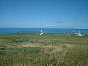
Cape Sōya — nihongo|Cape Sōya|宗谷岬|Sōya Misaki is the northernmost point of the island of Hokkaidō, Japan. It is situated in Wakkanai, Sōya Subprefecture. There is nihongo|the Monument of the Northernmost Point of Japan|日本最北端の地の碑 on the cape, although the… … Wikipedia
Soya — can mean:* soybean * Sōya District, Hokkaidō * Sōya Subprefecture, Hokkaidō * Soya3D, a high level three dimensional rendering engine for the Python programming language * Soya sauce, a fermented sauce made from soybeans, roasted grain, water and … Wikipedia
Cape Sata — (佐多岬, Sata Misaki ) is a cape at the southern tip of the Osumi Peninsula of Kyūshū island, Japan, and is the southernmost point of the island, just south of 31 degrees latitude.Cape Hata is home to a lighthouse built in 1871, designed by the… … Wikipedia
Japanese cruiser Soya — nihongo| Soya |宗谷 was a protected cruiser in the Imperial Japanese Navy, acquired as a prize of war during the Russo Japanese War from the Imperial Russian Navy, where it was originally known as the warship|Russian… … Wikipedia
Esashi, Hokkaidō (Sōya) — nihongo|Esashi|枝幸町|Esashi chō is a town in Esashi District, Sōya Subprefecture, Hokkaidō, Japan. As of 2007, its estimated population is 9,641 and its area is 1115.67 km². The name comes from the Ainu word Esaushi, meaning cape (in the geographic … Wikipedia
Extreme points of Japan — The extreme points, the points that are farther north, south, east or west than any other location in Japan, are the following.Nation; Northernmost point *Under Japanese control::nihongo|Bentenjima|弁天島, Cape Sōya, Wakkanai, Hokkaidō… … Wikipedia
Wakkanai, Hokkaidō — Infobox City Japan Name= Wakkanai JapaneseName= 稚内市 Map Region= Hokkaidō Prefecture= Hokkaidō District= Area km2= 760.80 PopDate= December 31, 2007 Population= 40,629 Density km2= 53.63 Coords= LatitudeDegrees= 45 LatitudeMinutes= 25… … Wikipedia
Geography of Japan — Continent Asia Region East Asia Coordinates … Wikipedia
La Perouse Strait — Japanese Sōya kaikyō Russian Proliv Laperuza International waterway between the Russian island of Sakhalin and the Japanese island of Hokkaido. The strait, named for the French explorer count de La Pérouse, separates the Sea of Okhotsk from the… … Universalium
Korean Air Lines Flight 007 — Flight 007 redirects here. For other uses, see Flight 7 (disambiguation). Korean Air Lines Flight 007 Artist s rendition of HL7442, the KAL 747 lost during Flight 007 Occurrence summary … Wikipedia
 La-Pérouse-Straße und Sachalin vom Kap Sōya aus gesehen