Dorah-Pass

Dorah-Pass

xxx

Dorah-Pass
Gebirgspässe in Afghanistan und Pakistan

Gebirgspässe in Afghanistan und Pakistan

Passhöhe 4.300 m
Ausbau Trekkingpass
Gebirge Karakorum
Karte
Dorah-Pass (Afghanistan)
Dorah-Pass
x x
Koordinaten 36° 6′ 55″ N, 71° 13′ 50″ O36.11520571.2306314300Koordinaten: 36° 6′ 55″ N, 71° 13′ 50″ O

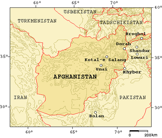
Der 4300 Meter hohe Dorah bzw. Dorahpass verbindet den Distrikt Zibak mit Chitral in Pakistan und überwindet den Hindu Kush.

Dieser Pass hatte große Bedeutung während der sowjetischen Invasion, da es ihnen nicht gelang den Waffentransport und die Bewegungen der Mudschahedin zu kontrollieren und zu stoppen. Der Pass war auch ein Fluchtweg nach Chitral.

Der Dorah-Pass war in den letzten 30 Jahren von großer wirtschaftlicher Bedeutung für die Region, da hierüber Edelsteine wie Smaragde und Lapislazuli sowie Lebensmittel und Vieh transportiert werden konnte.

Der Chitral-Distrikt ist nur über vier Gebirgspässe oder von Afghanistan aus über das Kunartal erreichbar. Die anderen Pässe sind der Lowari-Pass, der Broghol-Pass und der Shandur-Pass, der nach Gilgit in Pakistan führt. Im Frühjahr 2010 soll der 8,6 Kilometer lange Lowari-Tunnel fertiggestellt sein, der eine wintersichere Verbindung herstellen wird.

Weblink


Wikimedia Foundation.

Игры ⚽ Нужна курсовая?

Schlagen Sie auch in anderen Wörterbüchern nach:

  • Dorah Pass — Elevation 4,300 m (14,108 ft) Location Location …   Wikipedia

  • Lowari-Pass — xBWxxx Lowari Pass Passhöhe 3.120 m …   Deutsch Wikipedia

  • Shandur-Pass — xx Shandur Pass Karte von Gebirgsp …   Deutsch Wikipedia

  • Broghol-Pass — xx Broghol Pass Gebirgspässe in Afghanistan u …   Deutsch Wikipedia

  • Lowari Pass — Infobox Mountain Pass Name = Lowari Pass Photo = Caption = Photo of the tunnel that has been created. Photo Credits: Zain Abbass(UrbanPK.com) Elevation = 10,230 ft. Location = PAK Range = Hindu Raj Mountains Coordinates = Topographic Transversed… …   Wikipedia

  • Hindu Kush — a mountain range in S Asia, mostly in NE Afghanistan, extending W from the Himalayas. Highest peak, Tirich Mir, 25,230 ft. (7690 m). Also called Hindu Kush Mountains. * * * Latin Caucasus Indicus Mountain system, south central Asia. Some 600 mi… …   Universalium

  • Badakhshan — (PerB| بدخشان, Tajik: Бадахшон) is a region comprising parts of northeastern Afghanistan and southeastern Tajikistan. Badakhshan Province is one of the thirty four provinces of Afghanistan. It is in the east of Afghanistan, containing the Wakhan… …   Wikipedia

  • List of mountain passes — This is a list of mountain passes. Africa *Halfaya Pass *Moteng Pass (Lesotho) *Mahlasela pass (Lesotho)Asia* Khunjerab Pass Pakistan China (highest international border crossing at 4693 m.) * Khyber Pass Pakistan Afghanistan * Kotal e Lataband * …   Wikipedia

  • Broghol — Infobox Mountain Pass Name = Broghol Photo = Caption = Elevation = 3798 m./12,460 ft. Location = PAK / AFG Range = Pamir Mountains Coordinates = coord|37|00|N|73|26|E|type:pass Topographic Transversed by =Broghol, also spelled Boroghil and… …   Wikipedia

  • Chitral District —   District   Map of Khyber Pakhtunkhwa with Chitral District highlighted Country …   Wikipedia

Share the article and excerpts

Direct link
Do a right-click on the link above
and select “Copy Link”