Dunmail Raise

Dunmail Raise
54.495867-3.039955
Dunmail Raise (Vereinigtes Königreich)
Dunmail Raise
Dunmail Raise
Dunmail Raise

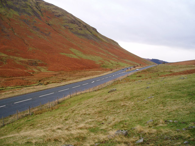
Dunmail Raise ist ein Gebirgspass im Lake District in Cumbria, England. Mit 238 m ist der Pass der höchste Punkt der A591 von Keswick nach Kendal südlich von Thirlmere und nördlich von Grasmere.

Im Osten des Passes liegt der Helvellyn und Fairfield, im Westen liegt der High Raise.

Auf dem Pass befindet sich ein großer Cairn, der als Grab von Dunmail, dem letzten König von Cumbria gilt und so erklärt sich der Name des Passes. Das Grab soll die historische Grenze zwischen Cumbria und Westmorland sein, obwohl es dafür keine Nachweise gibt.


Wikimedia Foundation.

Игры ⚽ Поможем сделать НИР

Schlagen Sie auch in anderen Wörterbüchern nach:

  • Dunmail Raise — (spr. dănmēl rēs ), Paßhöhe zwischen dem Helvellyn und Scafell (s. Cumbrian Mountains), 240 m hoch, wo 945 der Sachsenkönig Edmund über den König Dunmail von Cumberland siegte …   Meyers Großes Konversations-Lexikon

  • Dunmail Raise — A horse drawn coach passes northwards over Dunmail Raise in the late 19th or early 20th century Dunmail Raise is a hill in the English Lake District, the highest point (at 781 feet or 238 metres) of a pass on the Keswick Kendal road, the A591, to …   Wikipedia

  • Dunmail — Dunmail, last King of Cumbria (died 945) is a figure of both history and legend. In 945AD the Saxon king Edmund I of England conquered Strathclyde and ceded Cumbria to his ally, Malcolm I MacDonald, king of Scotland. This historical conflict is… …   Wikipedia

  • Steel Fell — Infobox Mountain Name = Steel Fell Photo = Caption = Elevation = 553 m (1,814 ft) Location = Cumbria, ENG Range = Lake District, Central Fells Prominence = c. 70 m Parent peak = High Raise Coordinates = Topographic OS Landranger 90, Explorer OL5… …   Wikipedia

  • Seat Sandal — Infobox Mountain Name = Seat Sandal Photo = Seat Sandal from Helm Crag.jpg Caption = Seat Sandal (left) and Fairfield (right) seen from Helm Crag two km to the SW. Location = Cumbria, ENG Range = Lake District, Eastern Fells Elevation = 736 m… …   Wikipedia

  • Central Fells — The Central Fells are a group of hills in the English Lake District. Reaching their highest point at High Raise (2,500 ft or 762 metres), they occupy a broad area to the east of Borrowdale. Perhaps unexpectedly the Central Fells are generally… …   Wikipedia

  • Fairfield (Lake District) — Infobox Mountain Name = Fairfield Photo = Fairfield.jpg Caption = Fairfield (right) and St Sunday Crag, seen from Seat Sandal Elevation = 873 m (2,863 ft) Location = Cumbria, ENG Range = Lake District, Eastern Fells Prominence = 299 m Parent peak …   Wikipedia

  • River Rothay — The Rothay is a spate river of the Lake District in north west England. Its name comes from Old Norse and translates literally as the red one . This has come to mean trout river . It rises close to Rough Crag above Dunmail Raise at a point about… …   Wikipedia

  • River Rothay — Rothay Trittsteine im Rothay bei RydalVorlage:Infobox Fluss/KARTE fehlt …   Deutsch Wikipedia

  • Dollywaggon Pike — Elevation 858 m (2,815 ft) …   Wikipedia

Share the article and excerpts

Direct link
Do a right-click on the link above
and select “Copy Link”