- Fort Altit
-
Fort Altit 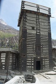
Der Turm des Altit Forts
Entstehungszeit: 11. Jh. Burgentyp: Höhenburg Erhaltungszustand: Restauriert Ort: Karimabad Geographische Lage 36° 18′ 54″ N, 74° 40′ 55″ O36.31574.681944444444Koordinaten: 36° 18′ 54″ N, 74° 40′ 55″ O 

Das Fort Altit ist ein altes Fort in Karimabad im Hunza-Tal in Gilgit-Baltistan in Pakistan. Es war lange Zeit der Hauptsitz der Herrscher des Hunza-Staates. Heute ist das Fort Altit ein Reiseziel für Touristen.
Das Fort drohte zu einer Ruine zu verfallen, bis es durch das Aga Khan Development Network für historische Städte restauriert wurde.
Lage und Erscheinungsbild
Das Fort liegt auf zwei Felsspitzen, wobei der Ostfelsen höher als der Westfelsen ist. Das Fort wurde daher an das natürliche Gelände angepasst und in sechs Terrassen mit unterschiedlichen Niveaus gegliedert. Die Abschnitte des Forts enthalten unter anderem eine Moschee, einen Kornspeicher und einen Gästetrakt.
Quellen
Kategorien:- Bauwerk in Pakistan
- Archäologischer Fundplatz in Pakistan
- Festung in Asien


Wikimedia Foundation.