Geladin

Geladin
6.966666666666746.416666666667
Geladin (Äthiopien)
Geladin
Geladin

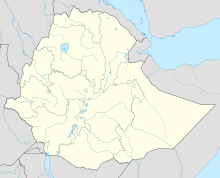
Geladin (auch Geladi, Galadi, Galladi[1]) ist ein Ort in der Warder-Zone der Somali-Region in Äthiopien. Es ist Hauptort der gleichnamigen Woreda Geladin und liegt nahe der Grenze zu Somalia.

Nach Angaben der Zentralen Statistikagentur Äthiopiens für 2005 hatte Geladin 10.795 Einwohner.[2] 1997 waren von 7.233 Einwohnern 99,15 % Somali, 60 Einwohner gehörten anderen ethnischen Gruppen an.[3]

Das Gebiet der Woredas Geladin und Boh gehört zum Haud. Die hier lebenden Somali gehören hauptsächlich zu den Clans der Majerteen- und Dolbohanta-Darod und sind nomadische Viehzüchter. Bis in die 1960er Jahre war Geladin neben Warder und Bulale eine der wenigen Wasserstellen in dem Gebiet, wo es auch in der Trockenzeit Wasser gab, und eine der wenigen festen Siedlungen. Die Brunnen von Geladin lieferten allerdings nicht immer ausreichend Wasser. Ein Großteil der Nomaden zog daher in der Trockenzeit zu Wasserstellen jenseits der Grenze in Somalia. 1954 wurde in der Nähe ein neues Bohrloch gegraben. Ab den 1960er Jahren und mehr noch nach der Dürre von 1974 (siehe auch Hungersnot in Somalia 1974) wurden zudem zahlreiche unterirdische Wasserspeicher (birked oder berkad genannt) in den Dörfern der Region angelegt.[4]

1978 blieb Geladin auch nach der Niederlage Somalias im Ogadenkrieg zunächst unter Kontrolle somalischer Truppen, ebenso wie Mustahil, Ferfer und Shilabo.[5]

Quellen

  1. The Nordic Africa Institute: Local History in Ethiopia (PDF)
  2. Central Statistical Agency: 2005 National Statistics, Section–B Population, Table B.4 (PDF)
  3. The 1994 Population and Housing Census of Ethiopia: Results for Somali Region, Volume I: Part I. Statistical Report on Population Size and Charateristics, 1998 (PDF), S. 74
  4. UNDP Emergencies Unit for Ethiopia: Changing Pastoralism in the Ethiopian Somali National Regional State (Region 5), 30. Mai 1998
  5. Gebru Tareke: The Ethiopia-Somalia War of 1977 Revisited, in: International Journal of African Historical Studies 33, 2002 (S. 660)

Wikimedia Foundation.

Игры ⚽ Нужно сделать НИР?

Schlagen Sie auch in anderen Wörterbüchern nach:

  • Geladin — (also known as Geladi) is a town in eastern Ethiopia. Located in the Werder Zone of the Somali Region, this town has a longitude and latitude of coord|06|57|N|42|25|E with an elevation between 427 and 530 meters above sea level.Based on figures… …   Wikipedia

  • Geladin — est une ville d Éthiopie située dans la zone Gode de la région Somali. Elle se trouve à 06°57′N 42°25′E / 6.95, 42.417 et entre 427 et 530  …   Wikipédia en Français

  • Geladin (woreda) — Geladin (Somali Geladdi) is one of the 47 woredas in the Somali Region of Ethiopia. Part of the Werder Zone, its boundaries shown by official sources vary. On the OCHA map for the Somali Region (copyright 2003), Geladin is bordered on the south… …   Wikipedia

  • Geladin (woreda) — 6°40′N 46°25′E / 6.667, 46.417 Geladin est un des 47 woredas de la région Somali …   Wikipédia en Français

  • Werder (woreda) — Werder is one of the 47 woredas in the Somali Region of Ethiopia, named after its administrative center, Werder. Part of the Werder Zone, its boundaries shown by official sources vary.On the OCHA map for the Somali Region (copyright 2003), Werder …   Wikipedia

  • Warder-Zone — Die Warder Zone ist eine Verwaltungszone der Somali Region in Äthiopien. Sie liegt im äußersten Osten der Region an der Grenze zu Somalia und bildet die östlichste Zone von ganz Äthiopien. Hauptstadt der Zone ist Warder (Wardheer, Werder). Nach… …   Deutsch Wikipedia

  • Somali Region — Infobox Regions of Ethiopia native name = ሶማሌ ክልል Gobolka Soomaalida Somalia conventional long name = the Somali Region common name = the Somali Region map caption = Map of Ethiopia highlighting Somali Region capital = Jijiga official languages …   Wikipedia

  • Werder Zone — Werder is one of nine Zones of the Somali Region in Ethiopia. This zone is named after its largest city, Werder.Werder is bordered on the south by Gode, on the west by Korahe, on the northwest by Degehabur, and on the northeast and southeast by… …   Wikipedia

  • List of woredas in the Somali Region — This is a list of the 47 woredas, or districts, in the Somali Region of Ethiopia, compiled from material on the Central Statistical Agency [http://www.csa.gov.et/text files/2005 national statistics.htm website] .*Afder (woreda) *Afdem (woreda)… …   Wikipedia

  • Danot (woreda) — Danot is one of the 47 woredas in the Somali Region of Ethiopia, named after its major town, Danot. Part of the Werder Zone, Danot is bordered on the south by Werder, on the west by the Degehabur Zone, on the north by Somalia, and on the east by… …   Wikipedia

Share the article and excerpts

Direct link
Do a right-click on the link above
and select “Copy Link”