Graham Island (Haida Gwaii)

Graham Island (Haida Gwaii)

Vorlage:Infobox Insel/Wartung/Höhe fehlt

Graham Island
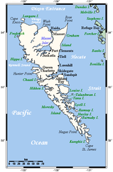
Karte des Archipels Haida Gwaii, Graham Island ist die nördliche Hauptinsel
Gewässer Pazifischer Ozean
Inselgruppe Haida Gwaii
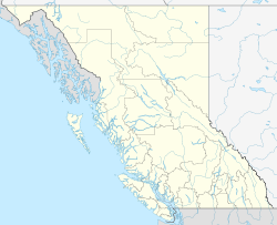
Geographische Lage 53° 20′ 0″ N, 132° 25′ 0″ W53.333333333333-132.41666666667Koordinaten: 53° 20′ 0″ N, 132° 25′ 0″ W
Graham Island (British Columbia)
Graham Island
Fläche 6.361 km²
Einwohner 4.475 (2001)
<1 Einw./km²
Hauptort Queen Charlotte City

Graham Island (Haida: Haida Gwaii, „Land der Haida“) ist die Hauptinsel der Haida Gwaii, einer Inselgruppe vor der Nordwestküste von British Columbia, Kanada im Pazifischen Ozean.

Inhaltsverzeichnis

Lage

Die Insel besitzt eine Fläche von 6.361 km². Der Skidegate Channel, eine schmale Meerenge im Süden, trennt sie von der zweiten Hauptinsel, Moresby Island (Haida: Gwaii Hanas).

Die Hecate Strait, die Graham Island vom Festland British Columbias trennt, erreicht zwischen Rose Spit und Stephens Island ihre schmalste Stelle mit einer Breite von etwa 55 Kilometer.

Bevölkerung

Ein Großteil der etwa 4.500 Einwohner siedelt in den folgenden 6 Siedlungen:

  • Juskatla - eine Holzfäller-Siedlung mit etwa 5 Einwohnern
  • Masset - etwa 950 Einwohner am Ende des Yellowhead Highway
  • Port Clements - etwa 450 Einwohner
  • Queen Charlotte City - etwa 950 Einwohner
  • Skidegate - Fährhafen der BC Ferries mit etwa 780 Einwohnern
  • Tlell - Siedlung am Südende des Naikoon Provincial Park mit etwa 220 Einwohnern

Ein Großteil der Einwohner gehört dem Volk der Haida an, in Skidegate und Old Masset befinden sich die Tribal Centre des Councils der Haida Nation.

Infrastruktur

Der Service der BC Ferries stellt eine Verbindung zwischen Skidegate und Prince Rupert, sowie Skidegate und Alliford Bay auf Moresby Island zur Verfügung.

Der Yellowhead Highway ist die einzige Straße von überregionaler Bedeutung, darüber hinaus gibt es einige unbefestigte Straßen, welche sich größtenteils auf den Südosten der Insel konzentrieren.

Weblinks


Wikimedia Foundation.

Игры ⚽ Поможем сделать НИР

Schlagen Sie auch in anderen Wörterbüchern nach:

  • Graham Island — ist der Name folgender Inseln einer Insel von Haida Gwaii in British Columbia in Kanada, siehe Graham Island (Haida Gwaii) einer Insel der Queen Elizabeth Islands in Nunavut in Kanada, siehe Graham Island (Nunavut) Inseln der Wessel Inseln im… …   Deutsch Wikipedia

  • Graham Island (Queen Charlotte Islands) — Vorlage:Infobox Insel/Wartung/Höhe fehlt Graham Island Karte der Queen Charlotte Islands, Graham Island ist die nördliche Hauptinsel Gewässer …   Deutsch Wikipedia

  • Haida Gwaii — Übersichtskarte der Inselgruppe Gewässer Pazifischer Ozean …   Deutsch Wikipedia

  • Haida Gwaii — (Haida Gwaii) Haida Gwaii a través de la estrecho de Skidegate, a bordo del M/V Queen of Prince Rupert (B.C. Ferries) …   Wikipedia Español

  • Graham Island — See also Graham Island (disambiguation). Infobox Islands name = Graham image caption = Graham Island is the large northern island image size = locator Location map|Canada British Columbia|lat=53.442264|long= 132.242432 map custom = yes native… …   Wikipedia

  • Isla Graham (Canadá) — Isla Graham Graham Island Haida Gwaii Localización País …   Wikipedia Español

  • Haida Argillite Carvings — came into existence during the 1800s. These carvings were mostly born out of the Haida desire to trade with the European explorers who came to their shores. Argillite carvings, therefore, are commonly seen as a tourist art because they were… …   Wikipedia

  • Haida-Seehundkeule — Angaben Waffenart: Keule Bezeichnungen …   Deutsch Wikipedia

  • Moresby Island — Karte des Archipels Haida Gwaii, Moresby Island im Süden Gewässer Pazifischer Ozean …   Deutsch Wikipedia

  • Liste kanadischer Inseln — Inhaltsverzeichnis 1 Liste kanadischer Inseln nach Fläche 2 Liste kanadischer Inseln nach Inselgruppe bzw. Provinz 2.1 Kanadisch arktischer Archipel 2.1.1 …   Deutsch Wikipedia

Share the article and excerpts

Direct link
Do a right-click on the link above
and select “Copy Link”