Hessle

Hessle
Hessle
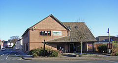
Hessle library.jpg
Koordinaten 53° 43′ N, 0° 26′ W53.7239-0.43190000000001Koordinaten: 53° 43′ N, 0° 26′ W
Hessle (England)
Hessle
Hessle
Bevölkerung 14.767 (Stand: 2001)
Verwaltung
Post town HESSLE
Postleitzahlen­abschnitt HU13
Vorwahl 01482
Landesteil England
Region Yorkshire and the Humber
Shire county East Riding of Yorkshire
District East Riding of Yorkshire
Britisches Parlament Kingston upon Hull West und Hessle
Website: http://www.thehesslefederation.co.uk

Hessle ist eine Kleinstadt in der englischen Unitary Authority East Riding of Yorkshire. Am Nordufer des Humber gelegen, grenzt sie direkt westlich an Kingston upon Hull und bildet mit der Großstadt praktisch einen einheitlichen urbanen Raum. Hessle besaß bei der Volkszählung im Jahre 2001 14.767 Einwohner.[1]

Inhaltsverzeichnis

Geografie

Nachbargemeinden Hessles sind (im Uhrzeigersinn, beginnend im Westen): North Ferriby, Swanland, Anlaby with Anlaby Common und die Großstadt Hull. Am gegenüberliegenden Ufer des Humber liegt der Hafen von New Holland sowie die Kleinstadt Barton-upon-Humber.

Verkehr

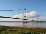
Humber-Brücke

Am südwestlichen Stadtrand verbindet die A15 (Hessle–Peterborough) über die mautpflichtige Humber-Brücke die beiden Ufer des Humber, wodurch das südlich gelegene Lincolnshire schnell zu erreichen ist. Über die sich nördlich fortsetzende A164 erreicht man Driffield über Beverley, und über die A63 (Hull–Leeds) erreicht man den M62, über welchen man Anschluss an das Autobahnnetz Großbritanniens hat.

Hessle besitzt zudem einen Bahnhof, von welchem direkte Zugverbindungen nach Hull, Leeds, Doncaster und York existieren.

Der nächste Flughafen ist der Humberside Airport, welcher sich etwa 30 km südlich in North Lincolnshire befindet.

Hessle ist außerdem Ausgangspunkt des Yorkshire Wolds Way, eines 127 km langen Wanderwegs, welcher über die Yorkshire Wolds nach Filey an die Nordseeküste führt.

Einzelnachweise

  1. 2001 Census: Key Statistics: Parish Headcounts: Area: Hessle CP (Parish). Neighbourhood Statistics. Office for National Statistics. Abgerufen am 17. Mai 2008.

Weblinks


Wikimedia Foundation.

Игры ⚽ Нужно сделать НИР?

Schlagen Sie auch in anderen Wörterbüchern nach:

  • Hessle — Hessle …   Wikipédia en Français

  • Hessle — infobox UK place country = England latitude = 53.7239 longitude = 0.4319 official name = Hessle static static image caption = Hessle library at Southgate civil parish = Hessle population = 14,767 (2001 census) unitary england = East Riding of… …   Wikipedia

  • Hessle — This early medieval surname is English, although perhaps with a dash of Viking. It was originally either topographical for someone who lived near a prominent hazel tree or farmed hazel nuts for food, or locational from one of the places whose… …   Surnames reference

  • Hessle — Original name in latin Hessle Name in other language State code GB Continent/City Europe/London longitude 53.72454 latitude 0.43842 altitude 11 Population 0 Date 2011 07 31 …   Cities with a population over 1000 database

  • Hessle High School — is a high school in Hessle, near Hull, England.The school is split over two sites. Years 7 and 8 are located on Boothferry Road, with years 9 and above on Heads Lane.The Heads Lane site is built around Tranby House, which was originally built in… …   Wikipedia

  • Hessle Sixth Form — is a sixth form college based at Hessle High School on Heads Lane Hessle, near Hull, in the East Riding of Yorkshire.The 200 students attending the sixth form study for qualifications at AS Level and A2 Level. The sixth form college is part of a… …   Wikipedia

  • Hessle railway station — Infobox UK station name = Hessle manager = Northern Rail locale = Hessle borough = East Riding of Yorkshire code = HES lowusage0405 = 27,628 lowusage0506 = 51,436 lowusage0607 = 37,303 platforms = 2 start = latitude = 53.71698 longitude = 0.44000 …   Wikipedia

  • hessle — Mawdesley Glossary to shuffle or squeeze through a crowd …   English dialects glossary

  • Kingston upon Hull West and Hessle (UK Parliament constituency) — UK constituency infobox Name =Kingston upon Hull West and Hessle Map1 = HullWestHessle Type = Borough Map2 = Humberside Entity = Humberside County = East Riding of Yorkshire Year = 1997 MP = Alan Johnson Party = Labour EP = Yorkshire and the… …   Wikipedia

  • List of Empire ships (F) — The Empire ships were a series of ships in the service of the British Government. Their names were all prefixed with Empire. Mostly they were used during the Second World War by the Ministry of War Transport (MoWT), which owned the ships but… …   Wikipedia

Share the article and excerpts

Direct link
Do a right-click on the link above
and select “Copy Link”