- Yorkshire Wolds Way
-
 Yorkshire Wolds Way
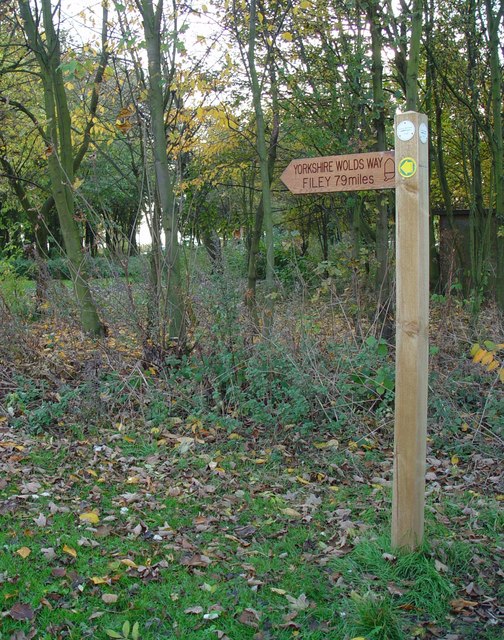
Der Yorkshire Wolds Way ist ein Wanderweg in England. Er wurde am 2. Oktober 1982 als National Trail im Land eingeweiht und führt von Hessle bei Hull in East Riding of Yorkshire nach Norden und Nordosten über die Yorkshire Wolds bis nach Filey, einer Kleinstadt an der Nordseeküste in North Yorkshire. Der Weg ist 127 km lang.
Literatur
- Walking The Wolds Way, David Clensy, 2007. ISBN 978-1-4303-1019-8
Weblinks
-
 Commons: Yorkshire Wolds Way – Sammlung von Bildern, Videos und Audiodateien
 - Der Yorkshire Wolds Way auf www.nationaltrail.co.uk
National Trails in England und Wales
Cleveland Way | Cotswold Way | Glyndŵr’s Way | Hadrian’s Wall Path | North Downs Way | Offa’s Dyke Path | Peddar’s Way | Pembrokeshire Coast Path | Pennine Bridleway | Pennine Way | The Ridgeway | South Downs Way | South West Coast Path | Thames Path | Yorkshire Wolds WayLong Distance Routes in Schottland
Great Glen Way | Southern Upland Way | Speyside Way | West Highland Way
Wikimedia Foundation.
Schlagen Sie auch in anderen Wörterbüchern nach:
Yorkshire Wolds Way — Infobox Hiking trail Name=Yorkshire Wolds Way Photo=Yorkshire Wolds Way Sign.jpg Caption=Yorkshire Wolds Way sign at Market Weighton Location=Yorkshire, England Designation=UK National Trail Length=convert|79|mi|km Start/End Points=Hessle, East… … Wikipedia
Yorkshire Wolds — Die Yorkshire Wolds sind ein Hügelzug in der englischen Grafschaft Yorkshire. Sie sind das höchstgelegene Gebiet im östlichen England zwischen dem Fluss Derwent im Westen und Nordwesten, dem Humber im Süden sowie der Nordsee im Osten. Der… … Deutsch Wikipedia
Yorkshire Wolds — Geobox|Region name = Yorkshire Wolds native name = other name = category = Hills etymology = official name = motto = nickname = image caption =A winter view across the Yorkshire Wolds symbol = country = England state = United Kingdom region =… … Wikipedia
Wolds de Yorkshire — Los Wolds de Yorkshire son una serie de colinas de baja altura en los condados de East Riding of Yorkshire y North Yorkshire en el noreste de Inglaterra. También se denomina así al distrito en el cual se encuentran las colinas. Sobre el costado… … Wikipedia Español
East Riding of Yorkshire — Basisdaten Status Unitary Authority Zeremonielle Grafschaft Region Yorkshire and the Humber Verwaltungssitz … Deutsch Wikipedia
Minster Way — Length 50 miles (80 Km) Location North East Yorkshire, UK Trailheads Beverley Minster 53°50′21.23″N … Wikipedia
Millington, East Riding of Yorkshire — Coordinates: 53°57′19″N 0°44′07″W / 53.955271°N 0.735413°W / 53.955271; 0.735413 … Wikipedia
Cleveland Way — Live Moor: the waymarked path crosses remote upland moors Length 110 miles (177 km) Location North Yorkshire, England Designation … Wikipedia
Melton, East Riding of Yorkshire — Coordinates: 53°43′34″N 0°31′47″W / 53.726187°N 0.529641°W / 53.726187; 0.529641 … Wikipedia
Viking Way — Infobox Hiking trail Name=Viking Way Photo= Caption= Location=Lincolnshire, England Designation= Length=Convert|147|mi|0 Start/End Points=Barton on Humber, Lincolnshire and Oakham, Rutland Use=Hiking ElevChange= HighPoint= LowPoint=… … Wikipedia
Yorkshire Wolds Way
18+
© Academic, 2000-2026
- Kontaktieren Sie uns: Unterstützung, Werbung
Wörterbücher Export, schritte mit PHP, Joomla, Drupal, WordPress, MODx.