- Hillsborough River State Park
-
Der Hillsborough River State Park zählt zu den Florida State Parks. Er liegt am U.S. Highway 301 in Zephyrhills, 11 Kilometer nordöstlich von Tampa. Er wird vom Fluss Hillsborough River in zwei Teile geteilt und umfasst 13,7 Quadratkilometer Fläche.
 Hillsborough River
Inhaltsverzeichnis
Natur
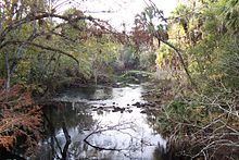
Die Besonderheit des Parks liegt in den Stromschnellen, die an der Stelle des Parks im Hillsborough River vorkommen. Sie sind bedingt durch Kalksteine im Boden des Flusses. Charakteristisch für die Pflanzenwelt im Park sind Zypressengewächse und Pinienwälder. Gopher Schildkröten, Spechte, Eulen, Rotluchse und Rehe können hier beobachtet werden.
Geschichte
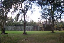 Fort Foster
1938 eröffnet gilt er als einer der ersten State Parks in Florida und wurde vom Civilian Conservation Corps angelegt. Viele Teile des Parks sind Beispiele für die rustikale Architektur des CCC. Das Fort Foster im Park ist eine Replica eines Militärforts aus dem Zweiten Seminolenkrieg, die einzige in den Vereinigten Staaten. Führungen um das Fort finden am Wochenende statt.
Aktivitäten
Der Park bietet Naturpfade zum Wandern über 11 Kilometer Länge. Man kann im Park Kanu fahren, Radfahren und Angeln. Es gibt einen Campingplatz, zwei Kinderspielplätze, einen Swimming-Pool sowie das Woods Café.
Weblinks
- Internetpräsenz auf www.floridastateparks.org (engl.)
-
 Commons: Hillsborough River State Park – Sammlung von Bildern, Videos und Audiodateien
 - Hillsborough River State Park im Geographic Names Information System des United States Geological Survey
28.145719-82.2328389Koordinaten: 28° 8′ 44,6″ N, 82° 13′ 58,2″ WKategorie:- State Park in Florida


Wikimedia Foundation.