- Joe Gqabi (Distrikt)
-
Joe Gqabi
Joe Gqabi District Municipality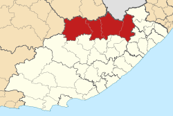
Symbole Wappen
Basisdaten Staat Südafrika Provinz Ostkap Sitz Barkley East Fläche 25.401,2 km² Einwohner 308.366 (24. Oktober 2007) Dichte 12,1 Einwohner pro km² Schlüssel DC14 ISO 3166-2 ZA-EC Webauftritt www.ukhahlamba.gov.za (englisch) Politik Bürgermeister Zibonele Dumzela -30.96666666666727.6Koordinaten: 30° 58′ S, 27° 36′ ODer Distrikt Joe Gqabi (früher Ukhahlamba) liegt in der Provinz Ostkap in Südafrika. Auf einer Fläche von 25.401 km² leben 308.366 Einwohner (Stand: 24. Oktober 2007).[1] Die Hauptstadt ist Barkley East.
Gemeindestruktur
Als Beispiel für die Infrastruktur hier die Wasserversorgung der Haushalte (HWA = eigener Hauswasseranschluss; ÖWA = öffentlicher Wasseranschluss in der Nähe; KWA = kein Anschluss an ein Wasserleitungsnetz)[2]:
Gemeinde Verwaltungssitz Fläche Einwohner HWA ÖWA KWA Elundini Maclear 5064 km² 137468 2 % 27 % 72 % Gariep Burgersdorp 8911 km² 31295 12 % 74 % 13 % Maletswai Aliwal North 4358 km² 37299 12 % 75 % 13 % Senqu Lady Grey 7330 km² 137723 2 % 50 % 48 % Einzelnachweise
- ↑ Community Survey 2007. Basic Results. Statistics South Africa, 24. Oktober 2007, abgerufen am 29. Juni 2010 (englisch)..
Hinweise zu den Daten (englisch). - ↑ Gemeindestatistik Südafrika
Distrikte des OstkapsAlfred Nzo | Amathole | Cacadu | Chris Hani | Nelson Mandela Bay | O.R. Tambo | Joe Gqabi
Wikimedia Foundation.
Schlagen Sie auch in anderen Wörterbüchern nach:
Chris Hani (Distrikt) — Chris Hani Chris Hani District Municipality Symbole … Deutsch Wikipedia
Liste der Gemeinden in der Provinz Ostkap — Die Provinz Ostkap mit eingezeichneten Distrikten und Gemeinden Die Liste der Gemeinden in der Provinz Ostkap führt alle Gemeinden (Local Municipalities) in der südafrikanischen Provinz Ostkap auf. Die Provinz Ostkap ist in 7 Distrikte (District… … Deutsch Wikipedia
Liste der Distrikte in Südafrika — Distrikte Südafrikas (nummeriert) Die Liste der Distrikte in Südafrika führt alle Distrikte (District Municipalities) in Südafrika auf. Legende Nr.: Nummer des Distrikts auf der oben angeführten Karte Distrikt: Name des Distrikts Voller Name:… … Deutsch Wikipedia
Elundini — Local Municipality Symbole … Deutsch Wikipedia
Gariep (Gemeinde) — Gariep Gariep Local Municipality Basisdaten … Deutsch Wikipedia
Maletswai (Gemeinde) — Maletswai Maletswai Local Municipality Symbole … Deutsch Wikipedia
Senqu — Local Municipality Symbole … Deutsch Wikipedia
Burgersdorp — Burgersdorp … Deutsch Wikipedia
Pixley Ka Seme — District Municipality Symbole … Deutsch Wikipedia
Amathole — District Municipality Symbole … Deutsch Wikipedia
- ↑ Community Survey 2007. Basic Results. Statistics South Africa, 24. Oktober 2007, abgerufen am 29. Juni 2010 (englisch)..
Joe Gqabi (Distrikt)


18+
© Academic, 2000-2026
- Kontaktieren Sie uns: Unterstützung, Werbung
Wörterbücher Export, schritte mit PHP, Joomla, Drupal, WordPress, MODx.