- Cacadu
-
Cacadu
Cacadu District Municipality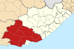
Symbole Wappen
Basisdaten Staat Südafrika Provinz Ostkap Sitz Port Elizabeth Fläche 58.243,9 km² Einwohner 363.485 (24. Oktober 2007) Dichte 6,2 Einwohner pro km² Schlüssel DC10 ISO 3166-2 ZA-EC Webauftritt www.cacadu.co.za (englisch) Politik Bürgermeister Khunjuzwa Eunice Kekana -33.9525.599996146111Koordinaten: 33° 57′ S, 25° 36′ OCacadu (englisch Cacadu District Municipality) liegt im westlichen Teil der Provinz Ostkap in Südafrika. Auf einer Fläche von 58.244 km² leben 363.485 (Stand: 24. Oktober 2007).[1] Die Hauptstadt ist Port Elizabeth.
Cacadu ist ein Xhosabegriff und beschreibt die Landschaft, gekennzeichnet durch halbaride Ebenen und wogende Berge, die sich bis zum Meer ausdehnt.[2]
Inhaltsverzeichnis
Gemeindestruktur
Als Beispiel für die Infrastruktur hier die Wasserversorgung der Haushalte (HWA = eigener Hauswasseranschluss; ÖWA = öffentlicher Wasseranschluss in der Nähe; KWA = kein Anschluss an ein Wasserleitungsnetz) [3]:
Gemeinde Verwaltungssitz Fläche (km²) Einwohner HWA ÖWA KWA Baviaans Willowmore 7.727 15.321 19 % 57 % 24 % Blue Crane Route Somerset East 9.836 35.002 12 % 68 % 20 % Camdeboo Graaff-Reinet 7.230 44.362 21 % 71 % 8 % Ikwezi Jansenville 4.453 10.358 14 % 65 % 22 % Kouga Jeffreys Bay 2.419 70.687 19 % 73 % 8 % Kou-Kamma Kareedouw 3.574 34.285 25 % 38 % 37 % Makana Grahamstown 4.376 75.295 11 % 79 % 9 % Ndlambe Port Alfred 1.841 53.604 13 % 70 % 17 % Sunday’s River Valley Kirkwood 3.508 39.853 6 % 62 % 32 % Nationalparks/Naturschutzgebiete
- Baviaanskloof Mega-Reserve (Teil des Cape Floral Kingdom und UNESCO-Weltnaturerbe )
- Addo Elephant National Park
- Tsitsikamma National Park
Weblinks
Offizieller Internetauftritt (englisch)
Einzelnachweise
- ↑ Community Survey 2007. Basic Results. Statistics South Africa, 24. Oktober 2007, abgerufen am 29. Juni 2010 (englisch)..
Hinweise zu den Daten (englisch). - ↑ Namensbedeutung Gemeinden
- ↑ Gemeindestatistik Südafrika
Distrikte des OstkapsAlfred Nzo | Amathole | Cacadu | Chris Hani | Nelson Mandela Bay | O.R. Tambo | Joe Gqabi
Wikimedia Foundation.
Schlagen Sie auch in anderen Wörterbüchern nach:
cacadu — cacadú s. m. Trimis de siveco, 10.08.2004. Sursa: Dicţionar ortografic CACADÚ m. 1) Specie de papagali cu penajul de obicei alb şi cu un moţ viu colorat. 2) Papagal din această specie. /<germ. Kakadu Trimis de siveco, 22.08.2004. Sursa:… … Dicționar Român
Cacadu District Municipality — Zamuni code=DC10 location=Eastern Cape area=58 242 neighbours= mayor=Mlungisi Gerald Mvoko population=388 201 [ [http://www.demarcation.org.za/municprofiles2003/index.asp Municipal Profiles] ] population density=6.67 persons habitations=… … Wikipedia
Cacadu District Municipality — Admin ASC 2 Code Orig. name Cacadu District Municipality Country and Admin Code ZA.05.DC10 ZA … World countries Adminstrative division ASC I-II
South African municipal election, 2006, in Cacadu District Municipality — The African National Congress won:* Makana * Kouga * Ndlambe * Camdeboo * Sunday s River Valley * Blue Crane * Kou Kamma * Ikwezi * AberdeenThe Democratic Alliance won:* Baviaans … Wikipedia
Liste der Gemeinden in der Provinz Ostkap — Die Provinz Ostkap mit eingezeichneten Distrikten und Gemeinden Die Liste der Gemeinden in der Provinz Ostkap führt alle Gemeinden (Local Municipalities) in der südafrikanischen Provinz Ostkap auf. Die Provinz Ostkap ist in 7 Distrikte (District… … Deutsch Wikipedia
Bavians — Baviaans Baviaans Local Municipality Baviaans (rot) in Ostkap Staat: Südafrika … Deutsch Wikipedia
Camdeboo Local Municipality — Camdeboo Camdeboo Local Municipality Camdeboo (rot) in Ostkap Staat: Südafrika … Deutsch Wikipedia
Sundays River Valley — Sunday’s River Valley Sunday’s River Valley Local Municipality Sunday’s River Valley (rot) in Ostkap Staat: Südafrika … Deutsch Wikipedia
Ndlambe Local Municipality — Local municipality Location … Wikipedia
Oyster Bay, Eastern Cape — Oyster Bay Town The eastern side of the bay … Wikipedia
Cacadu


18+
© Academic, 2000-2026
- Kontaktieren Sie uns: Unterstützung, Werbung
Wörterbücher Export, schritte mit PHP, Joomla, Drupal, WordPress, MODx.