Kaingaroa Forest

Kaingaroa Forest
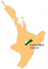
Lage des Kaingaroa Forest

Der Kaingaroa Forest ist der größte Wald auf der Nordinsel Neuseelands und die größte forstliche Anpflanzung der Südhalbkugel. Der Wald bedeckt 2900 km² im Bereich des East Cape und der Bay of Plenty. Er erstreckt sich östlich des Lake Taupo von Nordosten nach Südwesten. Die Forstverwaltung des Gebietes befindet sich in der Siedlung Kaingaroa, 50 km südöstlich von Rotorua.

Die ersten Pflanzungen erfolgten in den späten 1920er Jahren als Staatsforst [1][2], zu dieser Zeit unter den Namen Kaingaroa State Forest.

In den 1980er Jahren strebte die Regierung an, den Wald an private Eigner zu verkaufen. Mehrere Māori-Iwi gingen dagegen vor Gericht. Sie argumentierten, dass sie als traditionelle Eigentümer des Landes unrechtmäßig enteignet wurden und dass die Regierung das Land behalten solle bis die Ansprüche der Māori abschließend geklärt seien.[3][4]. Dies nahm 20 Jahre in Anspruch, am 1. Juli 2009 wurde das Land den traditionellen Eignern als Teil der Ausgleichsmaßnahmen der Regierung für den Bruch des Vertrages von Waitangi durch die Krone zurückgegeben. Das Holz befindet sich im Eigentum der privaten Kaingaroa Timberlands Ltd., die eine Lizenz zur forstwirtschaftlichen Bewirtschaftung des Landes besitzt.

Der State Highway 38 von Wai-O-Tapu nach Murupara und weiter durch Te Urewera nach Wairoa durchquert den Wald.

Einzelnachweise

  1. "New Zealand forestry and the forest code of practice"
  2. "The first planting boom, 1925–1935"
  3. "Treelord deal takes a step closer"
  4. "Largest ever Treaty deal 'Treelords' passes into law"

Wikimedia Foundation.

Игры ⚽ Поможем сделать НИР

Schlagen Sie auch in anderen Wörterbüchern nach:

  • Kaingaroa Forest — is the largest forest in the North Island of New Zealand, and the largest plantation in the southern hemisphere. The privately owned forest covers 2900 km² in the inland East Cape and Bay of Plenty regions, and stretches south past the east coast …   Wikipedia

  • Kaingaroa — is the name of several places in New Zealand: *Kaingaroa Forest: a forest and settlement in the Bay of Plenty *Kaingaroa: a settlement in Northland *Kaingaroa: a fishing establishment in the Chatham Islands.… …   Wikipedia

  • Kaingaroa State Forest — Forêt de Kaingaroa Emplacement de la forêt sur une carte de l île du Nord La forêt de Kaingaroa est la plus grande forêt de l île du Nord de la Nouvelle Zélande, ainsi que la plus grande sapinière de l hémisphère sud. Elle est située au …   Wikipédia en Français

  • Kaingaroa — Forêt de Kaingaroa Emplacement de la forêt sur une carte de l île du Nord La forêt de Kaingaroa est la plus grande forêt de l île du Nord de la Nouvelle Zélande, ainsi que la plus grande sapinière de l hémisphère sud. Elle est située au …   Wikipédia en Français

  • Forêt de Kaingaroa — Emplacement de la forêt sur une carte de l île du Nord La forêt de Kaingaroa est la plus grande forêt de l île du Nord de la Nouvelle Zélande, ainsi que la plus grande sapinière de l hémisphère sud. Elle est située au …   Wikipédia en Français

  • Murupara — …   Wikipedia

  • Murupara — Murupara …   Deutsch Wikipedia

  • Taupo District Council — Infobox Taupo District name= Taupo District Council The Taupo District Council is a local council located in the Central North Island of New Zealand.AreaThe district stretches from the small town of Mangakino in the northwest to the Tongariro… …   Wikipedia

  • New Zealand State Highway 5 — State Highway 5 Route information Maintained by …   Wikipedia

  • Otamatea River (Hawke's Bay) — For the riverine arm of the Kaipara Harbour, see Otamatea River (Northland). Otamatea River Origin Ahimanawa Range Mouth Rangitaiki River Basin countries New Zealand Length …   Wikipedia

Share the article and excerpts

Direct link
Do a right-click on the link above
and select “Copy Link”