- Ceredigion
-
Ceredigion Principal Area 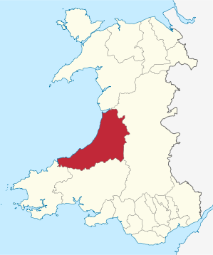
Verwaltungssitz Aberaeron Fläche 1.795 km² Einwohner 76.400[1] (2009) Walisischsprachige 61,2 % ISO 3166-2 GB-CGN ONS-Code 00NQ Website www.ceredigion.gov.uk Ceredigion (walisisch Sir Ceredigion) ist eine Unitary Authority im Westen von Wales. Verwaltungssitz ist Aberaeron, die größte Stadt ist Aberystwyth.
In Lampeter ist ein Teil der über den gesamten Landesteil verteilten University of Wales angesiedelt. Ein früher bedeutender Hafen war die Stadt Cardigan im Süden des Bezirks.
Cardiganshire
Weitgehend flächengleich mit Ceredigion ist die traditionelle Grafschaft Cardiganshire. Sie wird im Süden durch den River Teifi, Pembrokeshire und Carmarthenshire, im Westen durch die Irische See, im Osten durch Brecknockshire, Radnorshire und Montgomeryshire und im Norden durch Merionethshire begrenzt. Die historische Hauptstadt ist Cardigan. 1961 hatte Cardiganshire 53.564 Einwohner auf 1.793 km².[2]
Bis 1974 war Cardiganshire eine Verwaltungsgrafschaft und wurde dann zum District Ceredigion der neugebildeten Grafschaft Dyfed. Seit der Verwaltungsreform von 1996 ist Ceredigion eine Unitary Authority, in Wales auch Principal Area genannt. Ceredigion besitzt den Status eines County.
Weblinks
 Commons: Ceredigion – Sammlung von Bildern, Videos und Audiodateien
- Webseite des Ceredigion County Councils
- University of Wales, Lampeter
- Historisches Königreich Ceredigion
Einzelnachweise
- ↑ Amtliche Bevölkerungszahlen 2009
- ↑ rororo Duden-Lexikon 1966

Anglesey | Blaenau Gwent | Bridgend | Caerphilly | Cardiff | Carmarthenshire | Ceredigion | Conwy | Denbighshire | Flintshire | Gwynedd | Merthyr Tydfil | Monmouthshire | Neath Port Talbot | Newport | Pembrokeshire | Powys | Rhondda Cynon Taf | Swansea | Torfaen | Vale of Glamorgan | Wrexham
Wikimedia Foundation.
Schlagen Sie auch in anderen Wörterbüchern nach:
Ceredigion — Saltar a navegación, búsqueda Ubicación de Ceredigion en Gales. Ceredigion es una autoridad unitaria situada en la zona occidental de Gales. Está situado en el condados históricos de Cardiganshire. Tiene un área de 1.783 km² y una población … Wikipedia Español
Ceredigion — For other uses, see Ceredigion (disambiguation). Ceredigion Sir Ceredigion Geography Area Total % … Wikipedia
Ceredigion — 52° 15′ 10″ N 4° 00′ 01″ W / 52.2527, 4.00031 … Wikipédia en Français
Ceredigion — ▪ county, Wales, United Kingdom historical name Cardiganshire county in Wales, extending from the western coast on Cardigan Bay to inland hills and valleys and the upland of Plynlimon, with an elevation of 2,468 feet (752 metres).… … Universalium
Ceredigion — Sp Keredigionas Ap Ceredigion angliškai, vališkai L Velso ist. sr. ir grafystė, Jungtinė Karalystė … Pasaulio vietovardžiai. Internetinė duomenų bazė
Ceredigion — Sp Keredigionas Ap Ceredigion angliškai, vališkai L Velso ist. sr. ir grafystė, D. Britanija … Pasaulio vietovardžiai. Internetinė duomenų bazė
Ceredigion Museum — is a museum in Aberystwyth, Ceredigion, Wales. Contents 1 Location 2 History 3 Exhibition collection 4 Friends … Wikipedia
Ceredigion (journal) — Ceredigion is an annual local history journal about the history of the county of Ceredigion, Wales, published by Ceredigion Historical Society. The society was founded, as Cardiganshire Antiquarian Association, 1911 to promote the understanding… … Wikipedia
Ceredigion (disambiguation) — Ceredigion may mean or refer to: Ceredigion Ceredigion (UK Parliament constituency) Ceredigion (Assembly constituency) This disambiguation page lists articles associated with the same title. If an … Wikipedia
Ceredigion & Mid Wales NHS Trust — (Welsh: Ymddiriedolaeth GIG Ceredigion a Chanolbarth Cymru) was an NHS Trust in Wales. The headquarters of the Trust was based in the Bronglais General Hospital, in Aberystwyth. The Trust catered to the Ceredigion area, as well as large areas of… … Wikipedia
- Kontaktieren Sie uns: Unterstützung, Werbung
Ceredigion

18+
© Academic, 2000-2026
Wörterbücher Export, schritte mit PHP, Joomla, Drupal, WordPress, MODx.