- Kohama
-
Kohama Gewässer Pazifischer Ozean Inselgruppe Ryūkyū-Inseln Geographische Lage 24° 12′ 8,64″ N, 123° 35′ 8,16″ O24.2024123.585699Koordinaten: 24° 12′ 8,64″ N, 123° 35′ 8,16″ O 

Fläche 7,84 km² Höchste Erhebung Ōdake
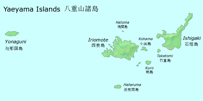
99 mHauptort Kohama, Taketomi Karte der Yaeyama-Inseln, Kohama im Osten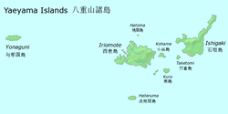
Kohama (jap. 小浜島, -jima; yaeyama: Kumō / okinawisch: Kubama[1]) ist eine Insel der Gemeinde Taketomi, Okinawa. Kohama gehört zur Gruppe der Yaeyama-Inseln.
Auf der Insel befindet sich der Ortsteil Kohama der Gemeinde Taketomi.
Einzelnachweise
Schlagen Sie auch in anderen Wörterbüchern nach:
Kohama — (小浜, 小濵 or 粉浜) may refer to: *Kohamajima, an island which is part of the town of Taketomi, Okinawa, Japan **Kohama is also the nickname of Taketomi, Okinawa. *Kohama gobo, one of the names of Gosho ji, a Buddhist temple in Takarazuka, Hyōgo… … Wikipedia
Kohama style — The nihongo|Kohama style|小浜流|Kohama ryū was a method of making sake during the Edo period in the Obama Domain of the former Settsu Province of Japan (now Takarazuka, Hyōgo Prefecture). Today, the method is used by homebrew enthusiasts or by small … Wikipedia
Kohama Station — is a train station in Sumiyoshi ku, Osaka Osaka Prefecture, Japan. Lines*Nankai Electric Railway **Nankai Main LineLayout*There are 2 island platforms with 4 tracks, however, Tracks 2 and 4 are fenced.Adjacent stations###@@@KEYEND@@@### … Wikipedia
Higashi-Kohama Station — is a station in Sumiyoshi ku, Osaka, Japan on the Hankai Tramway Hankai Line. The station is about 10m east from Kohama Station on the Nankai Main Line. History*1911 12 01: Higashi Kohama Station opens with the opening of the Hankai Tramway track … Wikipedia
Takarazuka, Hyōgo — Infobox City Japan Name= Takarazuka JapaneseName= 宝塚市 Map Region= Kansai Prefecture= Hyōgo District= Area km2= 101.89 PopDate= Apr 1, 2008 Population= 222,198 Density km2= 2161.0 Coords= LatitudeDegrees= 34 LatitudeMinutes= 48 LatitudeSeconds=… … Wikipedia
Gōshō-ji — nihongo|Gōshō ji|毫摂寺|gōshō ji is a Buddhist temple in Takarazuka, Hyōgo Prefecture, Japan. The other name of this temple is Kohama gobo (小浜御坊). Kohama is a name of the area around the temple and along the Arima Kaidō, which connected Osaka and… … Wikipedia
Yaeyama — Die Yaeyama Inseln Die Yaeyama Inseln (jap. 八重山諸島, Yaeyama shotō; wörtlich: Inselgruppe der achtfachen Berge, Ryūkyū Yaima) liegen im Südwesten der japanischen Präfektur Okinawa und bilden den westlichen Teil der Sakishima Inseln. Die Landfläche… … Deutsch Wikipedia
Yaeyama-Inselgruppe — Die Yaeyama Inseln Die Yaeyama Inseln (jap. 八重山諸島, Yaeyama shotō; wörtlich: Inselgruppe der achtfachen Berge, Ryūkyū Yaima) liegen im Südwesten der japanischen Präfektur Okinawa und bilden den westlichen Teil der Sakishima Inseln. Die Landfläche… … Deutsch Wikipedia
Yaeyama-shotō — Die Yaeyama Inseln Die Yaeyama Inseln (jap. 八重山諸島, Yaeyama shotō; wörtlich: Inselgruppe der achtfachen Berge, Ryūkyū Yaima) liegen im Südwesten der japanischen Präfektur Okinawa und bilden den westlichen Teil der Sakishima Inseln. Die Landfläche… … Deutsch Wikipedia
Sake — For other uses, see Sake (disambiguation). Dedicated sake barrels at Itsukushima Shrine … Wikipedia
Kohama
18+
© Academic, 2000-2024
- Kontaktieren Sie uns: Unterstützung, Werbung
Wörterbücher Export, schritte mit PHP, Joomla, Drupal, WordPress, MODx.