Lanigan (Saskatchewan)

Lanigan (Saskatchewan)
Lanigan
Die Hauptstraße in Lanigan
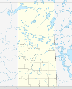
Lage in Saskatchewan
Lanigan (Saskatchewan)
Lanigan
Lanigan
Staat: Kanada
Provinz: Saskatchewan
Region: Saskatchewan
Koordinaten: 51° 51′ N, 105° 2′ W51.85-105.033333Koordinaten: 51° 51′ N, 105° 2′ W
Fläche: 8,34 km²
Einwohner: 1233 (Stand: 2009)
Bevölkerungsdichte: 147,8 Einw./km²
Zeitzone: CST
Postleitzahl: S0K 2M0
Gründung: 1907

Lanigan ist eine Ortschaft in der kanadischen Provinz Saskatchewan und liegt etwa 117 km östlich von Saskatoon. Die Ortschaft ist über den Saskatchewan Highway 16 und Saskatchewan Highway 20 zu erreichen. Lanigan zählt 1233 Einwohner (Stand 2006).[1]

Die Ortschaft verfügt über 560 Haushalte. Im Jahr 2006 betrug die Bevölkerungszahl 1233 Einwohner, dies bedeutete einen Rückgang von 4,3 Prozent im Vergleich zum Jahr 2001.[2] Lanigan umfasst eine Fläche von 8,34 km², die Bevölkerungsdichte beträgt 147,8/km².

Wichtige Wirtschaftszweige der Ortschaft sind die Stahlerzeugung, Kohleförderung und die Landwirtschaft.

Bekannte Persönlichkeiten

Weblinks

Einzelnachweise

  1. Lanigan – Population Statistics
  2. Statistics Canada (Census 2006). "Lanigan - Community Profile"

Wikimedia Foundation.

Игры ⚽ Нужен реферат?

Schlagen Sie auch in anderen Wörterbüchern nach:

  • Lanigan, Saskatchewan — Lanigan is a community in south central Saskatchewan, Canada, at the intersection of TransCanada Yellowhead Highway 16 and Highway 20, approximately 117 km east of Saskatoon and 170 Km north of Regina. Famous people*Age of Electric, a now… …   Wikipedia

  • Lanigan — ist der Familienname folgender Personen: Jim Lanigan (1902–1983), US amerikanischer Jazz Bassist William Lanigan (1820–1900), römisch katholischer Bischof ein Ort in Kanada, siehe Lanigan (Saskatchewan) Diese …   Deutsch Wikipedia

  • Lanigan Airport — is located convert|1.5|NM|abbr=on|lk=in east of Lanigan, Saskatchewan, Canada.References …   Wikipedia

  • Saskatchewan Highway 20 — Infobox road marker state= highway name=Highway 20 type= route= alternate name= maint= section= length mi=189.8 length round= length ref= length notes= established= decommissioned= direction a=south starting terminus=Lumsden beltway city=… …   Wikipedia

  • Saskatchewan Highway 16 — Infobox road marker province=SK name notes=Provincial Highway 5 and 14 (historic) type=Hwy route=16 alternate name=Yellowhead Trans Canada Highway maint=Ministry of Highways and Infrastructure Transport Canada length km=699.08 length round=2… …   Wikipedia

  • Wolverine No. 340, Saskatchewan — is a rural municipality in central Saskatchewan, Canada east of Saskatoon Wolverine No. 340 started out with the name Plasterfield from December 13, 1909 until March 31, 1910 when the name changed to Wolverine No. 340. Saskatchewan [… …   Wikipedia

  • List of communities in Saskatchewan — Communities of the Province of Saskatchewan, Canada are incorporated towns, cities, villages, and resort villages and unincorporated organized hamlets.[1] Regional rural forms of administration are rural municipalities.[clarification needed]… …   Wikipedia

  • Drake, Saskatchewan — Drake is a rural Saskatchewan village that lies just west of highway 20, approximately 11 KM (7 miles) south of its intersection with the Yellowhead Highway. It has a population of about 247 people. Drake is mostly a farming community, supported… …   Wikipedia

  • Colonsay, Saskatchewan — For other places with the same name, see Colonsay (disambiguation). Colonsay, Saskatchewan Railway Avenue Motto: Isle of the Prairies …   Wikipedia

  • Watson, Saskatchewan — Infobox City official name = Watson nickname = motto = Industrial Crossroads of Saskatchewan imagesize = 250px image caption = image mapsize = 250px map caption = mapsize1 = map caption1 = subdivision type = Country subdivision type1 = Provinces… …   Wikipedia

Share the article and excerpts

Direct link
Do a right-click on the link above
and select “Copy Link”