Chang Bhakar

Chang Bhakar
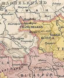
Kartenausschnitt aus dem Imperial Gazetteer of India

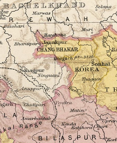
Chang Bhakar (auch Changbhakar; Hauptstadt Bharatpur, ab 1946 Janakpur) war ein Fürstenstaat Britisch-Indiens auf den Chota-Nagpur-Plateau im heutigen Bundesstaat Chhattisgarh. Das Fürstentum der Chauhan-Rajputen war ursprünglich ein Teil von Korea, 1818 machte es die Britische Ostindien-Kompanie zu einem eigenen Staat unter der Hoheit von Korea, 1848 zu einem eigenständigen britischen Protektorat (bis 1947). Er hatte 1901 eine Fläche von 2347 km² und 19.548 Einwohner.

Chang Bhakar schloss sich im August 1947 der Eastern States Union an. Am 1. Januar 1948 wurde diese Union aufgelöst und Chang Bhakar wurde Madhya Pradesh und damit Indien eingegliedert. Am 1. November 1956 wurden alle Fürstenstaaten aufgelöst. Seit dem 1. November 2000 gehört das Gebiet zum neu gebildeten Bundesstaat Chhattisgarh.

Literatur

  • Imperial Gazetteer of India, 2. A., 26 Bde., Oxford 1908-1931
  • Malleson, G. B.: An historical sketch of the native states of India, London 1875, Reprint Delhi 1984
  • Schwartzberg, Joseph E., Hrsg.: A historical atlas of South Asia, 2. A., New York/Oxford 1992, ISBN 0-19-506869-6

Weblinks


Wikimedia Foundation.

Игры ⚽ Поможем написать реферат

Schlagen Sie auch in anderen Wörterbüchern nach:

  • Chota Nagpur States — The Chota Nagpur States were a group of princely states at the time of British India, located on the Chhota Nagpur Plateau in the present day Indian states of Chhattisgarh, Jharkhand, and Orissa. In the 18th century, the states came within the… …   Wikipedia

  • Districts of Chhattisgarh — Chhattisgarh, a state of India, has eighteen administrative districts. A district of an Indian state is an administrative geographical unit, headed by a district magistrate or a deputy commissioner, an officer belonging to the Indian… …   Wikipedia

  • List of districts of Chhattisgarh — Chhattisgarh, a state of India, has 18 administrative districts. Two new districts, Bijapur and Naryanpur were carved out on May 11, 2007.[1] On August 15, 2011, Chief Minister Raman Singh announced that 12 new districts would be created in… …   Wikipedia

  • Central Provinces — Einteilung 1909 Die Central Provinces (C. P.) waren eine 1861 geschaffene Provinz Britisch Indiens, die sich ungefähr zwischen 17° 47 und 24° 27 N sowie 75° 57 und 84° 24 O erstreckte. Von ihren 292.265 km²[1][2] standen 211.800 km²… …   Deutsch Wikipedia

  • Central Provinces and Berar — The Central Provinces and Berar was a province of British India. The province comprised British conquests from the Mughals and Marathas in central India, and covered much of present day Madhya Pradesh, Chhattisgarh and Maharashtra states. Its… …   Wikipedia

  • Bengal Presidency — British Empire …   Wikipedia

  • Eastern States Union — Die Eastern States Union entstand, nachdem das britische Parlament am 15. August 1947 die Unabhängigkeit Indiens und Pakistans beschlossen hatte, und die indischen Fürstenstaaten dadurch unabhängig geworden waren. Die Fürsten der Eastern States… …   Deutsch Wikipedia

  • Liste indischer Fürstenstaaten — Patiala, Nabha, Malerkota, Jind und der Distrikt Ludhiana im Punjab (1911) Diese Liste indischer Fürstenstaaten gibt die bedeutenderen Staatsgebilde wieder, die zur Zeit der britischen Kolonialherrschaft auf dem Subkontinent (ohne Birma)… …   Deutsch Wikipedia

Share the article and excerpts

Direct link
Do a right-click on the link above
and select “Copy Link”