- Licking River (Ohio)
-
Licking River 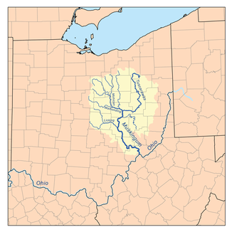
Der Licking River innerhalb des Einzugsgebiets des Muskingum Rivers
Daten Gewässerkennzahl US: 1070656 Lage Zentraler Bundesstaat Ohio, USA Flusssystem Mississippi River Abfluss über Muskingum → Ohio → Mississippi → Golf von Mexiko Ursprung Zusammenfluss von North Fork und South Fork Licking River in Newark im Licking County, Ohio
40° 3′ 10″ N, 82° 23′ 30″ W40.0528429-82.3915416242Quellhöhe 242 m[1] Mündung Muskingum River in Zanesville im nordwestlichen Holmes County, Ohio 39.940633-82.014572205Koordinaten: 39° 56′ 26″ N, 82° 0′ 52″ W
39° 56′ 26″ N, 82° 0′ 52″ W39.940633-82.014572205Mündungshöhe 205 m[1] Höhenunterschied 37 m Länge 23,7 km[2] Einzugsgebiet 2.018 km²[2] Bekannte Brücken Y-Bridge in Zanesville 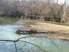 Der Licking River im Black Hand Gorge State Nature Reserve
Der Licking River ist ein 65 km langer rechter Nebenfluss des Muskingum River im zentralen US-Bundesstaat Ohio. Der Abfluss erfolgt über den Muskingum, Ohio und Mississippi River in den Golf von Mexiko. Er gehört zum Flusssystem des Mississippi und entwässert ein Gebiet von rund 2.018 km². Die beiden Quellflüsse North Fork Licking River und South Fork Licking River vereinigen sich bei der Ortschaft Newark im Licking County und bilden den Licking River. Der 55 km lange North Fork Licking River entspringt im südwestlichen Morrow County bei Centerburg, während der 50 km lange South Fork of Licking River im südwestlichen Licking County seine Quelle hat. Von Newark aus fließt der Licking River ostwärts durch das Black Hand Gorge State Nature Reserve, eine 6 km lange Sandsteinformation mit einer durch den Fluss gebildeten Schlucht.[3] Danach biegt der Licking River nach Südosten ab und mündet bei Zanesville in den Muskingum River. Beide Flüsse werden hier von einer wie ein Y geformten Brücke überspannt, der Y-Bridge. Einige Kilometer oberhalb von Zanesville hat das U.S. Army Corps of Engineers 1961 einen Staudamm gebaut, durch den der Dillon Lake gebildet wird. Laut dem Geographic Names Information System wurde der Fluss in seiner Besiedlungsgeschichte auch mit Licking Creek, Nepepenime Sepe, Pataskala River, Salt Lick Creek und ähnlichen Namen bezeichnet.[2]
Einzelnachweise
- ↑ a b Google Earth Höhenlage für GNIS-Koordinaten, abgerufen am 23. Juli 2010.
- ↑ a b c GNIS - Licking River in Ohio, abgerufen am 23. Juli, 2010
- ↑ Blackhand Gorge State Nature Preserveabgerufen am 23. Juli 2010
Weblinks


Wikimedia Foundation.