Monte Cetona

Monte Cetona
Monte Cetona
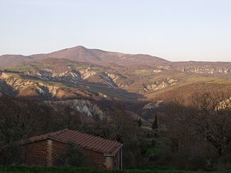
Der Monte Cetona von Süden aus gesehen

Der Monte Cetona von Süden aus gesehen

Höhe 1.148 m s.l.m.
Lage Toskana, Italien
Geographische Lage 42° 55′ 49″ N, 11° 52′ 31″ O42.93027777777811.8752777777781148Koordinaten: 42° 55′ 49″ N, 11° 52′ 31″ O
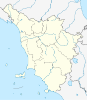
Monte Cetona (Toskana)
Monte Cetona

Der Monte Cetona ist ein Berg in der Toskana in Italien.

Inhaltsverzeichnis

Lage

Er liegt ca. 70 km südöstlich von Siena nahe der Gemeinde Cetona in der Provinz Siena, auf halbem Weg zwischen Florenz und Rom, und stellt mit seinen 1148 m die höchste Erhebung des Chianatals dar. Er ist Teil des Apennin und ist umgeben vom Chianatal und dem Val d’Orcia. Weitere anliegende Gemeinden neben Cetona sind San Casciano dei Bagni, Radicofani und Sarteano. Am südlichen Seitenhang entsteht der Fluss Orcia, der später in den Ombrone mündet.

Archäologie

Erste archäologische Arbeiten fanden 1927 durch Archäologen Umberto Calzoni aus Perugia statt. Dabei wurde die Grotta di San Francesco und die Grotta della Carbonaia entdeckt und freigelegt. 1928 wurden die Antro della Noce, Antro del Poggetto und die Tombetta della Strada, ein miteinander verbundenes Höhlensystem, entdeckt und ausgegraben. Erstmals menschlich besiedelt waren diese Höhlen von den Neandertalern, später dann in der Bronzezeit und in der Jungsteinzeit. Die Ausgrabungen des Calzoni fanden bis 1941 statt. 1984 haben die Universität Siena und die Soprintendenza Archeologica per la Toscana die Forschungen wieder aufgenommen.

Sehenswürdigkeiten

  • Grotta di San Francesco, Grotte, in der der hl. Franz von Assisi einen Zeitraum verbracht haben soll.
  • Museo Civico per la Preistoria del Monte Cetona, Museum
  • Parco Archeologico-Naturalistico del Monte Cetona, Naturpark

Weblinks

 Commons: Cetona – Sammlung von Bildern, Videos und Audiodateien

Wikimedia Foundation.

Игры ⚽ Нужно решить контрольную?

Schlagen Sie auch in anderen Wörterbüchern nach:

  • MONTE CETONA —    A limestone mountain above the Val di Chiana that provided a focus of Final Bronze Age and earlier settlement on its flanks (Casa Carletti), in caves (e.g., Antro della Noce, Grotta Lattaia), and on its summit (Vetta). Later Archaic settlement …   Historical Dictionary of the Etruscans

  • Cetona —   Comune   Comune di Cetona …   Wikipedia

  • Cetona — Cetona …   Deutsch Wikipedia

  • CETONA —    One of a small number of smaller Archaic settlements, in this case on the flanks of Monte Cetona, associated with Chiusi, in North Etruria, indicating the more decentralized organization of the local landscape compared with South Etruria …   Historical Dictionary of the Etruscans

  • ARCHAIC —    The period of full urbanization and/or state formation and the height of power of the Etruscans between approximately 580 and 400 BC. Artistically, the term archaic period acknowledges a parallelism to the Greek world and implies a process of… …   Historical Dictionary of the Etruscans

  • San Casciano dei Bagni — San Casciano dei Bagni …   Deutsch Wikipedia

  • Sarteano — Sarteano …   Deutsch Wikipedia

  • FINAL BRONZE AGE —    The final phase of the Bronze Age dating between approximately 1175 and 925 BC (using latest adjustments from dendrochronology), also known as the Protovillanovan in central Italy. Settlements were of village dimensions, ranging from one to 15 …   Historical Dictionary of the Etruscans

  • Geografía de Toscana — Altimetría de la Toscana. La geografía de la Toscana ilustra las características de la región Toscana, en Italia, que se extiende entre el mar de Liguria y el mar Tirreno, enfrente de los cuales queda con costas en grandes tramos bajas y arenosas …   Wikipedia Español

  • Orcia (rivière) — Orcia Caractéristiques Longueur  ? Bassin  ? Débit moyen  ? …   Wikipédia en Français

Share the article and excerpts

Direct link
Do a right-click on the link above
and select “Copy Link”