Narran River

Narran River
Narran River
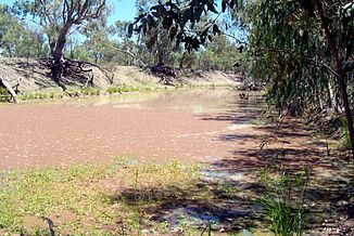
Narran River ca. 25 km nördlich des Narran Lake

Narran River ca. 25 km nördlich des Narran LakeVorlage:Infobox Fluss/KARTE_fehlt

DatenVorlage:Infobox Fluss/GKZ_fehlt
Lage Queensland / New South Wales (Australien)
Flusssystem Murray River
Verzweigung in der Flussaue Balonne River bei Dirranbandi
28° 36′ 29″ S, 148° 11′ 42″ O-28.608055555556148.195179
Quellhöhe 179 m[1]
Mündung Narran Lake
-29.6010583147.4001614118

29° 36′ 4″ S, 147° 24′ 1″ O-29.6010583147.4001614118
Mündungshöhe 118 m[1]
Höhenunterschied 61 m
Länge 299 km[1]Vorlage:Infobox Fluss/EINZUGSGEBIET_fehlt

Vorlage:Infobox Fluss/ABFLUSS_fehlt

Durchflossene Seen Narran Lake
Kleinstädte Dirranbandi QLD, Redbank QLD, Angledool NSW, Bangate NSW, Boomali NSW, Narran Plains NSW

Der Narran River ist ein Fluss im Osten Australiens an der Grenze zwischen den Bundesstaaten Queensland und New South Wales. Zusammen mit dem Culgoa River und dem Bokhara River ist der Narran River ein Arm des Balonne River – und zwar der östlichste dieser drei. Er fließt nach Süden auf den Barwon River, einen Quellfluss des Darling River, zu, erreicht in aber nicht, sondern endet im abflusslosen Narran Lake nördlich des Barwon River.

Im März 2010 flutete der Narran River bei Angledool den Angledool Lake und lief dann in den Weetalabah Creek über, der den Castlereagh Highway quert. Damit füllte sich auch der Coocoran Lake in der Nähe der Lightning Ridge[2] Gleiches geschah auch bei der großen Flut in Queensland Ende Januar / Anfang Februar 2011.

Quelle

List of placenames ASSIGNED as RIVERs. Geographical Names Register (GNR) of NSW. Geographical Names Board of New South Wales

Einzelnachweise

  1. a b c Map of Narran River. Bonzle.com
  2. Flooding of the Coocoran Lake. MyFoxMaine.com

Wikimedia Foundation.

Игры ⚽ Нужно сделать НИР?

Schlagen Sie auch in anderen Wörterbüchern nach:

  • Narran River — Origin Queensland Mouth Narran Lake Basin countries …   Wikipedia

  • Narran County — Map of all coordinates from Google Map of all coordinates from Bing Export all coordinates as KML …   Wikipedia

  • Narran Wetlands — The wetlands are important for Black fronted Dotterels The Narran Wetlands, also known as the Narran Lakes, comprise a series of ephemeral lakes and swamps fed by the Narran River in north central New South Wales, Australia. They are important… …   Wikipedia

  • Narran County, New South Wales — Infobox Australian cadastral name = Narran state = New South Wales caption = Location in New South Wales near nw = Queensland near n = Queensland near ne = Queensland near e = Finch near se = Leichardt near s = Clyde near sw = Gunderbooka near w …   Wikipedia

  • Balonne River — Balonne RiverVorlage:Infobox Fluss/GKZ fehlt Lage Queensland (Australien) Flusssystem Murray River Abfluss über Culgoa River → Darl …   Deutsch Wikipedia

  • Condamine River — Condamine River, Warwick, Queensland, 2009 …   Wikipedia

  • Bokhara River — Bokhara RiverVorlage:Infobox Fluss/GKZ fehlt Lage Queensland / New South Wales (Australien) Flusssystem Murray River Abfluss über Barwo …   Deutsch Wikipedia

  • Distributary — A distributary, or a distributary channel, is a stream that branches off and flows away from a main stream channel. They are a common feature of river deltas. The phenomenon is known as river bifurcation. The opposite of a distributary is a… …   Wikipedia

  • Finch County — Map of all coordinates from Google Map of all coordinates from Bing Export all coordinates as KML …   Wikipedia

  • Finch County, New South Wales — Infobox Australian cadastral name = Finch state = New South Wales caption = Location in New South Wales near nw = Queensland near n = Queensland near ne = Queensland near e = Benarba near se = Denham near s = Leichardt near sw = Clyde near w =… …   Wikipedia

Share the article and excerpts

Direct link
Do a right-click on the link above
and select “Copy Link”