- Nesluša
-
Nesluša
Wappen Karte 
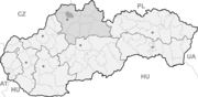

Nesluša BasisdatenKraj: Žilinský kraj Okres: Kysucké Nové Mesto Region: Severné Považie Fläche: 25,479 km² Einwohner: 3.273 (31. Dez. 2010) Bevölkerungsdichte: 128,46 Einwohner je km² Höhe: 410 m n.m. Postleitzahl: 023 41 Telefonvorwahl: 0 41 Geographische Lage: 49° 19′ N, 18° 45′ O49.30972222222218.746388888889410Koordinaten: 49° 18′ 35″ N, 18° 44′ 47″ O Kfz-Kennzeichen: KM Gemeindekennziffer: 509302 StrukturGemeindeart: Gemeinde Verwaltung (Stand: März 2011)Bürgermeister: Marian Chovaňák Adresse: Obecný úrad Nesluša
978
023 41 NeslušaWebpräsenz: www.neslusa.sk Gemeindeinformation
auf portal.gov.skStatistikinformation
auf statistics.skNesluša (ungarisch Neszlény - bis 1902 Neszlusa) ist eine große Gemeinde im Okres Kysucké Nové Mesto innerhalb des Žilinský kraj in der Slowakei.
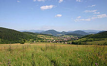 Blick auf den Ort
Der Ort liegt unter dem Gebirge Javorníky am Bach Neslušanka und ist vier Kilometer von Kysucké Nové Mesto entfernt, woher auch der einzige Straßenzugang besteht. Neben dem Hauptort selbst liegen im Gebirge 22 Einzelsiedlungen (slow. kopanice).
Nesluša wurde zum ersten Mal 1367 als Neszlusa schriftlich erwähnt und gehörte zum Herrschaftsgut der Burg Budatín.
Weblinks
 Commons: Nesluša – Sammlung von Bildern, Videos und AudiodateienGemeinden im Okres Kysucké Nové Mesto
Dolný Vadičov | Horný Vadičov | Kysucké Nové Mesto (Kischützneustadt) | Kysucký Lieskovec | Lodno | Lopušné Pažite | Nesluša | Ochodnica | Povina | Radoľa | Rudina | Rudinka | Rudinská | Snežnica
Wikimedia Foundation.
Schlagen Sie auch in anderen Wörterbüchern nach:
Nesluša — (Village) Administration Pays Slovaquie … Wikipédia en Français
Nesluša — Coordinates: 49°19′N 18°45′E / 49.317°N 18.75°E / 49.317; 18.75 … Wikipedia
Žilina Region — Geobox | Region name = Žilina other name = category = Region image caption = symbol = CoA Žilina Region Slovakia.png symbol type = Coat of arms etymology = official name = motto = nickname = country = Slovakia country state = region = district =… … Wikipedia
Kysucké Nové Mesto District — District Country Slovakia … Wikipedia
List of municipalities and towns in Slovakia — Slovakia This is a comprehensive list of municipalities and towns in Slovakia. For lists of towns and municipalities sorted by Regions see the individual articles on Regions. For an outdated list of towns only in Slovakia see also List of towns… … Wikipedia
Dolný Vadičov — Location of Kysucké Nové Mesto District in the Žilina Region Dolný Vadičov is a village and municipality in Kysucké Nové Mesto District in the Zilina Region of northern Slovakia. History In historical records the … Wikipedia
Ochodnica — Coordinates: 49°21′N 18°47′E / 49.35°N 18.783°E / 49.35; 18.783 … Wikipedia
Jozef Dunajovec — Infobox Person name = Jozef Dunajovec image size = 180px caption = Jozef Dunajovec birth date = March 23 1933 birth place = Nesluša, Slovakia death date = February 22 2007 death place = Bratislava, SlovakiaJozef Dunajovec (March 23 1933 –… … Wikipedia
Kischützneustadt — Kysucké Nové Mesto Wappen Karte … Deutsch Wikipedia
Kysucke Nove Mesto — Kysucké Nové Mesto Wappen Karte … Deutsch Wikipedia
Nesluša


18+
© Academic, 2000-2025
- Kontaktieren Sie uns: Unterstützung, Werbung
Wörterbücher Export, schritte mit PHP, Joomla, Drupal, WordPress, MODx.