- New Dorp Lighthouse
-
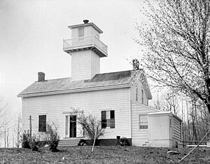
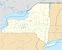
New Dorp Lighthouse New Dorp Lighthouse Ort: Staten Island, New York City Lage: Altamont Ave. Geographische Lage 40° 34′ 51″ N, 74° 7′ 12″ W40.580833333333-74.12Koordinaten: 40° 34′ 51″ N, 74° 7′ 12″ W Feuerträgerhöhe: 24 m Feuerhöhe: 58 m Optik: Fresnel-Linse zweiter Ordnung Bauzeit: 1854–1856 Betriebszeit: 1856–1964 Internationale Ordnungsnummer: ARLHS: USA-537 [1] Das New Dorp Lighthouse ist ein außer Dienst gestellter Leuchtturm in New Dorp in Staten Island, New York City. Die Mittel für den bau des Leuchtturmes wurden vom Kongress der Vereinigten Staaten am 31. August 1852 bewilligt. 1856 wurde das Bauwerk fertiggestellt. Die Anlage diente als Markierung der Einfahrt in den Swash Channel, einem Wasserweg in der Lower New York Bay. Sie wurde von Richard Carlow geplant, der etwa zurselben Zeit das Chapel Hill Light und das Point Comfort Range Lights in New Jersey erbaute. Schiffe die den Swash Channel befuhren, mussten das Leuchtfeuer in New Dorp ansteuern, bis das Chapel Hill Light in Sicht kam, das den Verlauf der Fahrrinne ab der West Bank markierte.
Ursprünglich hatte der Leuchtturm eine Fresnel-Linse zweiter Ordnung mit einem ständigen roten Licht, das ¨sich 192 Fuß (rund 58 m) über dem Meeresspiegel. 1891 wurde das Lichtzeichen in ein ständiges weißes Licht geändert. 1907 wurde die Lichtquelle von Öl auf eine elektrische Lichtquelle umgestellt, wodurch die Leuchtstärke erhöht wurde. 1939 wurde eine sechsstufige Fresnel-Linse installiert.
Das New Dorp Lighthouse wurde 1964 außer Dienst gestellt und verrammelt. Die nächsten zehn Jahre wurden Grundstück und Bauwerk vernachlässigt und vandalisiert; 1974 wurde es in einer Auktion für 32.000 US-Dollar an einen Privatmann aus Staten Island versteigert, der es ausgiebig renovierte und in eine Wohnung umwandelte.[2][3]
New Dorp Light wurde 1974 in das National Register of Historic Places aufgenommen.[4] Bereits 1967 wurde das Bauwerk, das von der Öffentlichkeit nicht besichtigt werden kann, als New York City Landmark ausgewiesen.
Belege
- ↑ ARLHS World List of Lights
- ↑ Northeast Lights: Lighthouses and Lightships, Rhode Island to Cape May, New Jersey, Robert Bachand, 1989.
- ↑ American Lighthouses, 2nd: A Definitive Guide By Bruce Roberts, Ray Jones Publisher: Globe Pequot; 2nd edition (1. September 2002) ISBN: 076272269X
- ↑ National Register Information System. National Register of Historic Places. National Park Service. Abgerufen am 13. März 2009.
Weblinks
Kategorien:- Erbaut in den 1850er Jahren
- Leuchtturm in den Vereinigten Staaten
- Denkmal im National Register of Historic Places (New York)
- Bauwerk in Staten Island
Wikimedia Foundation.


