Nkangala

Nkangala
Nkangala
Nkangala District Municipality
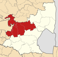
Map of Mpumalanga with Nkangala highlighted (2011).svg
Symbole
Wappen
Wappen
Basisdaten
Staat Südafrika
Provinz Mpumalanga
Sitz MiddelburgVorlage:Infobox Verwaltungseinheit/Wartung/Sonstiges
Fläche 16.892,6 km²
Einwohner 1.226.498 (24. Oktober 2007)
Dichte 72,6 Einwohner pro km²
Schlüssel DC31
ISO 3166-2 ZA-MP
Webauftritt www.nkangaladm.org.za (englisch)
Politik
Bürgermeister Katisi Speedy MashiloVorlage:Infobox Verwaltungseinheit/Wartung/Sonstiges

Nkangala ist ein Distrikt innerhalb der Provinz Mpumalanga in Südafrika. Er hat 1.226.498 Einwohner (Stand: 24. Oktober 2007).[1] auf einer Gesamtfläche von 16.893 Quadratkilometern. Sitz der Distriktverwaltung ist Middelburg. Der Distrikt ist benannt nach dem Zulubegriff für Highveld. Die meisten Städte des Distriktes liegen im Highveld.[2]

Gemeinden und Infrastruktur

Die Infrastruktur ist zwischen den städtischen und mehr ländlichen Gemeinden sehr unterschiedlich, als Beispiel hier die Wasserversorgung der Haushalte (HWA = eigener Hauswasseranschluss; ÖWA = öffentlicher Wasseranschluss in der Nähe; KWA = kein Anschluss an ein Wasserleitungsnetz)[3]:

Gemeinde Verwaltungssitz Fläche Einwohner H W A Ö W A K W A
Victor Khanye Delmas 1.568 km² 56.205 36 % 49 % 15 %
Dr JS Moroka Siyabuswa 1.416 km² 243.308 26 % 43 % 31 %
Emalahleni eMalahleni 2.678 km² 276.414 37 % 54 % 9 %
Steve Tshwete Middelburg 3.976 km² 142.761 39 % 52 % 9 %
Emakhazeni Belfast 4.736 km² 43.008 38 % 41 % 21 %
Thembisile Empumalanga 2.384 km² 258.878 36 % 57& 7 %

Weblinks und Quellen

Einzelnachweise

  1. Community Survey 2007. Basic Results. Statistics South Africa, 24. Oktober 2007, abgerufen am 29. Juni 2010 (englisch)..
    Hinweise zu den Daten (englisch).
  2. Namensbedeutung Gemeinden
  3. Municipal Demarcation Board

Wikimedia Foundation.

Игры ⚽ Поможем написать курсовую

Schlagen Sie auch in anderen Wörterbüchern nach:

  • Nkangala (Distrikt) — Nkangala Nkangala District Municipality Nkangala (blau) in Mpumalanga (dunkelgrau) Staat: Südafrika …   Deutsch Wikipedia

  • Nkangala District Municipality — A map of Mpumalanga showing the Nkangala district Nkangala is one of the 3 districts of Mpumalanga province of South Africa. The seat of Nkangala is Middelburg. The Nkangala District Municipality consists of 160 towns and villages. The most… …   Wikipedia

  • Nkangala language — Not to be confused with Ngangela language. Nkangala Spoken in Angola Native speakers 22,300  (2000) Language family Niger–Congo Atlantic–Congo …   Wikipedia

  • Nkangala District Municipality — Admin ASC 2 Code Orig. name Nkangala District Municipality Country and Admin Code ZA.07.DC31 ZA …   World countries Adminstrative division ASC I-II

  • Nkangala — ISO 639 3 Code : nkn ISO 639 2/B Code : ISO 639 2/T Code : ISO 639 1 Code : Scope : Individual Language Type : Living …   Names of Languages ISO 639-3

  • Liste der Gemeinden in der Provinz Mpumalanga — Mpumalanga mit eingezeichneten Distrikten und Gemeinden Die Liste der Gemeinden in der Provinz Mpumalanga führt alle Gemeinden (Local Municipalities) in der südafrikanischen Provinz Mpumalanga auf. Mpumalanga ist in 3 Distrikte (District… …   Deutsch Wikipedia

  • Delmas Local Municipality —   Local municipality   Location in M …   Wikipedia

  • Dr JS Moroka Local Municipality —   Local municipality   Location in …   Wikipedia

  • Liste der Gemeinden Südafrikas — Dies ist eine Liste der südafrikanischen Gemeinden. Inhaltsverzeichnis 1 Metropolgemeinden 2 Freistaat 2.1 Xhariep – Xhariep District Municipality (DC16) 2.2 …   Deutsch Wikipedia

  • Siyabushwa — Siyabuswa DEC …   Deutsch Wikipedia

Share the article and excerpts

Direct link
Do a right-click on the link above
and select “Copy Link”