Orkney Tunnel

Orkney Tunnel
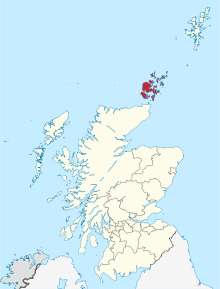
Die Orkney Inseln in Schottland
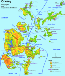
Karte der Orkney Inselgruppe mit Topografie und wichtigsten Verkehrswegen

Der Orkney Tunnel ist ein Vorschlag für einen unterseeischen Straßentunnel unter dem Pentland Firth zwischen Orkney und Caithness auf dem schottischen Festland. Die zu erwartende Länge beträgt circa 15 bis 16 km.

Es wird angenommen, dass der Tunnel, auf South Ronaldsay anlanden soll und insgesamt circa £ 100.000.000 kosten wird. Es gibt darüber hinaus auch Pläne, The Mainland Orkney mit Shapinsay zu verbinden.[1][2]

Einzelnachweise

  1. £100m tunnel to Orkney 'feasible', Scotsman.com, 10. März 2005
  2. Isle tunnel plans under spotlight , BBC News, 9. März 2009

Wikimedia Foundation.

Игры ⚽ Нужен реферат?

Schlagen Sie auch in anderen Wörterbüchern nach:

  • Orkney Tunnel — The Orkney Tunnel is a suggested undersea road tunnel between Orkney and Caithness on the Scottish Mainland. The expected length of it would be about 9 10 miles (15 16 km). Orkney Islands in Scotland …   Wikipedia

  • Mainland, Orkney — Location OS grid reference …   Wikipedia

  • British Isles — This article is about the archipelago in north western Europe. For the group of territories with constitutional links to the United Kingdom, see British Islands. British Isles English: British Isles Irish: Éire agus an Bhreatain Mhór[1] or… …   Wikipedia

  • Shapinsay — Infobox Scottish island | GridReference=HY505179 celtic name= norse name=Hjálpandisey meaning of name= Old Norse for helpful island or judge s island area=2,948 hectares area rank=29 highest elevation=Ward Hill 64 metres Population=300 population …   Wikipedia

  • Edinburgh —    EDINBURGH, a city, the seat of a university, and the metropolis of the kingdom of Scotland, situated in longitude 3° 10 30 (W.), and latitude 55° 57 29 (N.), about a mile (S. by W.) from Leith, 40 miles (S.S.W.) from Dundee, 42 (E. by N.) from …   A Topographical dictionary of Scotland

  • United Kingdom — a kingdom in NW Europe, consisting of Great Britain and Northern Ireland: formerly comprising Great Britain and Ireland 1801 1922. 58,610,182; 94,242 sq. mi. (244,100 sq. km). Cap.: London. Abbr.: U.K. Official name, United Kingdom of Great… …   Universalium

  • Список островов Шотландии — Карта Внешних и Внутренних Гебрид Этот список содержит перечисление морских и пресноводных островов Шотландии (континентальная часть которой является частью острова Великобритания). Помимо того, в список включены связанные с рас …   Википедия

  • Geschichte der Färöer — 1919 entworfen und das erste Mal gehisst; zwanzig Jahre daraufhin „Aufrührerfahne“; nach der britischen Besetzung der Färöer im Zweiten Weltkrieg am 25. April 1940 anerkannt; und im Autonomiegesetz der Färöer 1948 bestätigt: Merkið, die Flagge… …   Deutsch Wikipedia

  • Fogou — Souterrain (auch Earthhouse, kornisch: Fogou; schottisch: Weem) ist in der Archäologie die Bezeichnung für teils sehr komplexe vorgeschichtliche unterirdische Bauten, die aus Stein oder mit größeren Steinanteilen errichtet wurden, in Teilen… …   Deutsch Wikipedia

  • James I of Scotland — James I King of Scots Reign 4 April 1406 – 21 February 1437 Coronation 21 May 1424 Predecessor …   Wikipedia

Share the article and excerpts

Direct link
Do a right-click on the link above
and select “Copy Link”