Peveril Point

Peveril Point
Peveril Point
Durlston Bay, mit Peveril Point, auf der Isle of Purbeck, im Hintergrund Old Harry Rocks
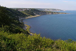
Gewässer Ärmelkanal

Geographische Lage

50° 21′ 51,48″ N, 1° 34′ 0,84″ W50.3643-1.5669Koordinaten: 50° 21′ 51,48″ N, 1° 34′ 0,84″ W
Peveril Point (England)
Peveril Point

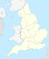
Peveril Point ist eine Landspitze und bildet den östlichsten Teil der Isle of Purbeck, einer Halbinsel an der Küste von Grafschaft Dorset, an der Südküste von England. Peveril Point ist Teil der Stadt Swanage.

Oben auf dem Hügel ist eine Küstenwachen-Hütte. Peveril Point ist auch die Heimat der Swanage-Rettungsboot-Organisation.[1]

Der Landzunge enthält unterirdische Tunnel. Diese Tunnel verbinden stillgelegte Geschützstellungen, die während des Zweiten Weltkriegs den Eingang aus dem Westen zur Southampton Waters verteidigten.

Die Felsen von Peveril Point sind aus Schiefer sowie aus Portland- und Purbeck-Kalkstein in einer Mulden-Struktur. Von Orcombe Point, bei Exmouth in Westen, bis zur Isle of Purbeck im Osten erstreckt sich ein Küstenstreifen, der als erste Naturlandschaft in England von der UNESCO zum Weltnaturerbe erklärt wurde. Peveril Point ist Teil der Jurassic Coast, es zählt zu den Naturwundern dieser Welt und ist bekannt für seine Fossilien.

Siehe auch

Einzelnachweise

  1. Ward, Lock and Company, ltd, & Hammond, R. J. W. (1974). Complete England. London: Ward Lock, p. 94.

Wikimedia Foundation.

Игры ⚽ Поможем решить контрольную работу

Schlagen Sie auch in anderen Wörterbüchern nach:

  • Peveril Point — is a promontory forming the easternmost part of the Isle of Purbeck in Dorset, England, and is part of the town of Swanage.It is located at coord|50|36.43|N|01|56.69|W|display=inline,title OS Grid Ref: SZ 041 787.On top is a coastguard hut. The… …   Wikipedia

  • Isle of Purbeck — Fishermans ledge in Purbeck Gewässer Ärmelkanal …   Deutsch Wikipedia

  • National Coastwatch Institution — The National Coastwatch Institution s Logo The National Coastwatch Institution [1] is a voluntary organisation and registered charity[2] providing a visual watch along the UK s coasts, and is not to be confused with HM Coastguard …   Wikipedia

  • Liste der Orte entlang der Jurassic Coast — Die Geoneedle am Orcombe Point nahe Exmouth besteht aus verschiedenen Gesteinsarten, die entlang der Jurassic Coast zu finden sind. Eine Liste der Orte entlang der Jurassic Coast an der Südküste Englands, von Devon bis in die Grafschaft Dorset… …   Deutsch Wikipedia

  • Discordant coastline — Durlston Head (limestone) to Handfast Point (chalk), with Peveril Point (limestone) dividing Durlston Bay from Swanage Bay A discordant coastline occurs where bands of differing rock type run perpendicular to the coast. The differing resistance… …   Wikipedia

  • Swanage — Town Hall …   Deutsch Wikipedia

  • Swanage — Infobox UK place official name= Swanage country= England region= South West England shire county= Dorset shire district= Purbeck constituency westminster= South Dorset population= 10,124 (2001) os grid reference= SZ0278 latitude= 50.61 longitude …   Wikipedia

  • Durlston Bay — 50.6006185 1.9468117 Koordinaten: 50° 36′ 2″ N, 1° 56′ 49″ W …   Deutsch Wikipedia

  • Purbeck-Monokline — Die Purbeck Monokline (engl. Purbeck Monocline) ist eine geologische Falte, die von den Purbeck Hills auf der Halbinsel Purbeck an der Südküste von England bis zur Isle of Wight reicht. Sie entstand während des späten Oligozäns und frühen Miozäns …   Deutsch Wikipedia

  • Isle of Man Railway locomotives — The locomotives of the Isle of Man Railway were provided exclusively by Beyer, Peacock and Company of Manchester, England between 1873 and 1926; other locomotives that appear on this list were inherited as part of the take over of the Manx… …   Wikipedia

Share the article and excerpts

Direct link
Do a right-click on the link above
and select “Copy Link”