- Pulap
-
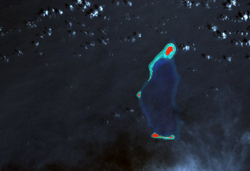
Pulap Landsat-Falschfarbenbild von Pulap
Gewässer Pazifik Archipel Karolinen Geographische Lage 7° 35′ N, 149° 25′ O7.5833333333333149.41666666667Koordinaten: 7° 35′ N, 149° 25′ O 

Anzahl der Inseln 3 Hauptinsel Pulap Länge 13 km Breite 6 km Landfläche 99,2 ha Lagunenfläche 31,321 km² Gesamtfläche 43 km² Einwohner 1270 (2000) Karte von Chuuk, das Atoll Pulap im Westen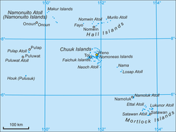
Pulap ist ein bewohntes Atoll im zentralen Pazifischen Ozean. Geographisch gehört es zum Archipel der Karolinen, politisch zum Bundesstaat Chuuk der Föderierten Staaten von Mikronesien.
Inhaltsverzeichnis
Geographie
Pulap liegt 29 km nördlich des benachbarten Atolls Puluwat sowie 220 km westlich des Chuuk-Atoll im Zentrum des Bundesstaates. Das Atoll hat in Nord-Süd-Richtung eine Länge von 13 km, in Ost-West-Richtung eine maximale Breite von 6 km sowie eine Gesamtfläche von 43 km².[1] Weite Teile des Saumriffs liegen bis zu 10 m tief unter der Wasseroberfläche, sodass von See aus der Atoll-Charakter nur schwach ausgeprägt ist. Die Fläche der damit weitgehend offenen und bis zu 35 m tiefen[1] Lagune beträgt 31,3 km²,[2] die gesamte Landfläche hingegen nur 0,99 km².[3] Dem Korallensaum liegen drei dicht bewachsene Inseln auf, Pulap im Norden, die Doppelinsel Tamatam im Süden sowie das kleine und unbewohnte Inselchen Fanadik im Westen des Atolls.[4]
Bevölkerung und Verwaltung
Pulap besteht aus den beiden Gemeinden (municipalities) Pollap im Norden mit 905 Einwohnern sowie Tamatam im Süden mit 365 Einwohnern (Stand: 2000).[5] Gemeinsam mit den Gemeinden Houk und Poluwat bildet sie die statistische Region Pattiw der Inselregion Oksoritod. Die Bevölkerung spricht Puluwatesisch, eine mit dem Chuukesischen verwandte Mikronesische Sprache.
Weblinks
- Pulap auf Oceandots (englisch)
Einzelnachweise
- ↑ a b Atoll Area, Depth and Rainfall (2001) Tabelle der Geological Society of America (Abgerufen am 17. August 2010)
- ↑ Otis W. Freeman, Geography of the Pacific, Wiley Verlag, 1953
- ↑ Reptiles of Satawan Atoll and the Mortlock Islands, Chuuk State, Federated States of Micronesia (englisch; PDF) (Abgerufen am 17. August 2010)
- ↑ National Geospatial-Intelligence Agency: Sailing Directions (enroute), Pub. 126, Pacific Ocean (englisch; PDF) (Abgerufen am 17. August 2010)
- ↑ Chuuk State Census Report, 2000 (englisch; PDF) (Abgerufen am 17. August 2010)
Schlagen Sie auch in anderen Wörterbüchern nach:
pułap — {{/stl 13}}{{stl 8}}rz. mnż I, D. u, Mc. pułappie {{/stl 8}}{{stl 20}} {{/stl 20}}{{stl 12}}1. {{/stl 12}}{{stl 7}} drewniany sufit, strop; powała : {{/stl 7}}{{stl 10}}Pułap zdobiony malowidłami. {{/stl 10}}{{stl 20}} {{/stl 20}}{{stl 12}}2.… … Langenscheidt Polski wyjaśnień
pułap — m IV, D. u, Ms. pułappie; lm M. y 1. «w drewnianym stropie belkowym: pokład z desek przymocowany pod belkami; podsufitka; potocznie: drewniany strop albo sufit» Ktoś, coś sięga do pułapu. ∆ Ślepy pułap «w drewnianym stropie belkowym: wewnętrzna… … Słownik języka polskiego
Pulap — Original name in latin Pulap Name in other language State code FM Continent/City Pacific/Chuuk longitude 7.6366 latitude 149.42878 altitude 8 Population 0 Date 2011 01 03 … Cities with a population over 1000 database
Puluwat — Vorlage:Infobox Insel/Wartung/Höhe fehlt Puluwat NASA Foto des Atolls Puluwat Gewässer Pazifischer Ozean … Deutsch Wikipedia
Liste der Inseln der Föderierten Staaten von Mikronesien — Karte der Föderierten Staaten von Mikronesien Die Liste der Inseln der Föderierten Staaten von Mikronesien listet alle Inseln, Inselgruppen und Atolle diese Inselstaates auf, geordnet alphabetisch nach Bundesstaat. Alle Inseln und Atolle gehören… … Deutsch Wikipedia
belkować — ndk IV, belkowaćkuję, belkowaćkujesz, belkowaćkuj, belkowaćował, belkowaćowany środ. «układać belki pod wiązania stropowe» ∆ Belkowany sufit, strop, pułap «sufit, strop, pułap z widocznymi belkami» … Słownik języka polskiego
chmura — ż IV, CMs. chmurze; lm D. chmur 1. «zawieszone w atmosferze widzialne skupienie drobniutkich kropelek wody, kryształków lodu albo ich mieszaniny, powstające w wyniku kondensacji pary wodnej» Ciężka, czarna, granatowa, ołowiana chmura. Chmura… … Słownik języka polskiego
USS Tunny (SS-282) — The USS Tunny (SS/SSG/APSS/LPSS 282) was a Gato class submarine which saw service in World War II and in the Vietnam War. Tunny received nine battle stars and two Presidential Unit Citation (US)s for her World War II service and five battle stars … Wikipedia
USS Pogy (SS-266) — USS Pogy (SS 266), a Gato class submarine, was the first ship of the United States Navy to be named for the pogy, a trout found in Lake Tahoe, California.The first Pogy (SS–266) was laid down 15 September 1941 by the Manitowoc Shipbuilding Co.,… … Wikipedia
Pwo — is a sacred initiation ritual, in which students of traditional navigation in the Caroline Islands in Micronesia become master navigators and are initiated in the associated secrets. Many islanders in the area indicate that this ceremony… … Wikipedia
Pulap

18+
© Academic, 2000-2026
- Kontaktieren Sie uns: Unterstützung, Werbung
Wörterbücher Export, schritte mit PHP, Joomla, Drupal, WordPress, MODx.