Pępowo

Pępowo
Pępowo
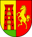
Wappen von Pępowo
Pępowo (Polen)
Pępowo
Pępowo
Basisdaten
Staat: Polen
Woiwodschaft: Großpolen
Landkreis: Gostyń
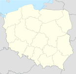
Geographische Lage: 51° 46′ N, 17° 7′ O51.76194444444417.119166666667Koordinaten: 51° 45′ 43″ N, 17° 7′ 9″ O
Einwohner:

1780 (2006)

Postleitzahl: 63-830
Telefonvorwahl: (+48) 65
Kfz-Kennzeichen: PGS
Gemeinde
Gemeindeart: Landgemeinde
Gemeindegliederung: 17 Ortschaften
13 Schulzenämter
Fläche: 86,7 km²
Einwohner:

6050
(31. Dez. 2010) [1]

Bevölkerungsdichte: 70 Einw./km²
Gemeindenummer (GUS): 3004042
Verwaltung
Gemeindevorsteher: Stanisław Krysicki
Adresse: ul. St. Nadstawek 6
63-830 Pępowo

Pępowo (deutsch Pempowo, 1939–1945 Waldeneck)[2] ist eine Stadt und Sitz der gleichnamigen Landgemeinde in Polen. Der Ort liegt im Powiat Gostyński der Wojewodschaft Großpolen.

Gemeinde

Zur Landgemeinde Pępowo gehören 13 Ortsteile (deutsche Namen bis 1945)[3] mit einem Schulzenamt:

  • Babkowice (Frauendorf)[2]
  • Czeluścin (Czeluscin, 1939–1945 Deutschrode)[2]
  • Gębice (Luckenau, 1939–1945 Deutschrode)[2]
  • Kościuszkowo (Waldeck, 1939–1945 Deutschrode)[2]
  • Krzekotowice
  • Krzyżanki (Krzyzanski, 1939–1945 Scharfeneck)[2]
  • Ludwinowo (Ludwinowo, 1939–1945 Langmeil)[2]
  • Magdalenki (Magdalenowo, 1939–1945 Klein Huben)[2]
  • Pasierby (Pasierby, 1939–1945 Waisenort)[2]
  • Pępowo (Pempowo, 1939–1945 Waldeneck)[2]
  • Siedlec (Siedlec, 1939–1945 Schädlitz)[2]
  • Skoraszewice (Skoraszewice, 1939–1945 Baldenau)[2]
  • Wilkonice

Eine weitere Ortschaft der Gemeinde ist Czeluścinek.

Fußnoten

  1. Population. Size and Structure by Territorial Division. As of December 31, 2010. Główny Urząd Statystyczny (GUS), abgerufen am 23. Juni 2011.
  2. a b c d e f g h i j k l Vgl. Forum Ahnenforschung - deutsche Ortsnamen im Wartheland
  3. Das Genealogische Orts-Verzeichnis

Wikimedia Foundation.

Игры ⚽ Поможем решить контрольную работу

Schlagen Sie auch in anderen Wörterbüchern nach:

  • Pępowo Kartuskie (PKP station) — Infobox PKP station name = Pępowo Kartuskie city = Pępowo district = address = ??? prec = Żukowo Wschodnie following = Rębiechowo water tower = Never existed depot = Never existed platforms = 1 building = Demolished start = prev name = Pępowo… …   Wikipedia

  • Pepowo — Original name in latin Ppowo Name in other language State code PL Continent/City Europe/Warsaw longitude 51.76569 latitude 17.12661 altitude 118 Population 1780 Date 2010 09 23 …   Cities with a population over 1000 database

  • Gmina Pępowo — Infobox Settlement name = Gmina Pępowo other name = Pępowo Commune settlement type = Gmina total type = Total image shield = subdivision type = Country subdivision name = POL subdivision type1 = Voivodeship subdivision name1 = Greater Poland… …   Wikipedia

  • Galeria Pępowo — (Жуково,Польша) Категория отеля: Адрес: Armii Krajowej 50, 83 330 Жуково, Польша …   Каталог отелей

  • Czeluścin, Gostyń County — See also: Czeluścin, Gniezno County Czeluścin   Village   …   Wikipedia

  • Magdalenki, Greater Poland Voivodeship — See also: Magdalenki, Łódź Voivodeship Magdalenki   Village   …   Wikipedia

  • Гмина Пемпово — Gmina Pępowo Герб Страна:  Польша Повят:  Гостыньский повят Глава:  Станислав Крысицкий Площадь:  86,71 км² …   Википедия

  • Czeluścinek —   Village   Country Poland Voivodeship Greater Poland …   Wikipedia

  • Pasierby — Pasierby …   Deutsch Wikipedia

  • Powiat Gostynski — Powiat Gostyński …   Deutsch Wikipedia

Share the article and excerpts

Direct link
Do a right-click on the link above
and select “Copy Link”