Road to the Isles

Road to the Isles
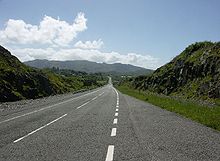
Streckenabschnitt bei Morar

Road to the Isles ist eine Panoramastraße im schottischen Hochland. Sie liegt in der Unitary Authority Highland und verbindet die Orte Fort William und Mallaig. Sie verläuft weitgehend parallel zur Trasse der West Highland Railway, auf der der Jacobite Steam Train verkehrt.

Die Straße ist etwa 70 Kilometer lang und führt an zahlreichen Sehenswürdigkeiten der Highlands vorbei. Sie beginnt im Touristenzentrum Fort William. Nach wenigen Kilometern erreicht der Reisende die Schleusentreppe des Kaledonischen Kanals, Neptune's Staircase genannt, in Banavie. Danach biegt die Straße nach Westen ab und führt entlang der Nordküste von Loch Eil. Wenige Kilometer weiter westlich trifft man auf das Glenfinnan Monument am Loch Shiel und auf den aus mehreren Filmen bekannten Glenfinnan Viaduct. Anschließend verläuft die Straße parallel zum malerischen Loch Eilt, um wenig später die schottische Westküste zu erreichen, von wo aus sich einige spektakuläre Blicke auf die Inseln Rum und die Eigg eröffnen. Die Route führt nun nach Norden entlang jener Küstenabschnitte, die als Drehorte für die Strandaufnahmen im Film Local Hero verwendet wurden. Als besonders sehenswert gilt dabei der silbrig schimmernde Strandabschnitt bei Morar, welcher auch als Silver Sands of Morar bekannt ist. Wenige Kilometer weiter nördlich endet die Route am Fährhafen von Mallaig.

Die Route der Road to the Isles entspricht weitgehend dem Verlauf der A830. Reisende können diese gut ausgebaute Straße aber in Arisaig verlassen und auf die parallel verlaufende B8008 wechseln, die wesentlich näher an der Küste entlang verläuft. Beide Straßen treffen bei Morar wieder zusammen.

Weblinks


Wikimedia Foundation.

Игры ⚽ Нужен реферат?

Schlagen Sie auch in anderen Wörterbüchern nach:

  • The Road to the Isles — is a famous Scottish traditional song. It is said to have been played by Bill Millen, piper to Lord Lovat, during the D Day invasion.The lyrics mention locations the road passes, including (in order): the Cuillin Hills, Tummel, Loch Rannoch,… …   Wikipedia

  • The Road of the Eagles — (a.k.a. Conan, Man of Destiny) is a 1955 Conan the Barbarian novelette by L. Sprague de Camp based on a story by Robert E. Howard, by the same name. It is usually credited to Howard and de Camp. Differences from Howard s original story De Camp… …   Wikipedia

  • Conan of the Isles —   Conan of the …   Wikipedia

  • Inn at the Isles — (Isle la Motte,США) Категория отеля: Адрес: 2925 West Shore Road, Isle la Motte, V …   Каталог отелей

  • Our Lady of the Isles — (Gaelic: Moire ro Naomh nan Eilean or Bana Thighearna nan Eilean) is a sculpture of the Virgin Mary, on South Uist in the Outer Hebrides of Scotland. The statue is situated on the western slopes of Ruabhal, a hill near the northern end of South… …   Wikipedia

  • The Pilot (Lewisporte, Newfoundland and Labrador) — The Pilot is a weekly newspaper published on Wednesdays in Lewisporte, Newfoundland and Labrador. The newspaper covers the Lewisporte region, as well as the islands of Fogo and Twillingate and smaller communities within the Road to the Isles… …   Wikipedia

  • The Rifles — Infobox Military Unit unit name=The Rifles caption=Cap and back badges of The Rifles dates=1st February 2007 country=United Kingdom branch=Army type=Rifles role=1st Battalion Commando 2nd Battalion Light Role 3rd Battalion Light Role 4th… …   Wikipedia

  • The Carmelite Order —     The Carmelite Order     † Catholic Encyclopedia ► The Carmelite Order     One of the mendicant orders.     Origin     The date of the foundation of the Order of Our Lady of Mount Carmel has been under discussion from the fourteenth century to …   Catholic encyclopedia

  • The Mall at 163rd Street — The mall s east entrance Location North Miami Beach, Florida   …   Wikipedia

  • The Road of Kings —   The Road of Kings by …   Wikipedia

Share the article and excerpts

Direct link
Do a right-click on the link above
and select “Copy Link”