- Seletar Expressway
-
Seletar Expressway in Singapur 
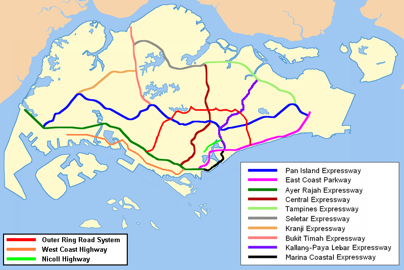
Karte 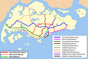
Basisdaten Betreiber: Land Transport Authority Gesamtlänge: 12 km - Woodlands
- Yio Chu Kang
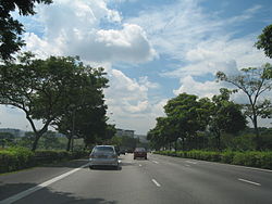
Seletar Expressway in östliche Richtung vor Woodlands. Straßenverlauf
(1AB) Seletar IC 


Sungai Seletar Simpang Bridge 
(3) Lentor IC (5) Upper Thomson IC Upper Seletar Flyover (8B) Mandai Ave (8A) Mandai Rd (9) Ulu Sembawang IC (10) Marsiling IC (11) Woodlands South IC 

Turf Club Ave Der Seletar Expressway (Abkürzung: SLE, chin.: 实 里 达 高速公路; Pinyin: Shílǐdá Gāosù Gōnglù; Tamil: செலேத்தார் விரைவுச்சாலை; ; malay: Lebuhraya Seletar) ist eine Autobahn in Singapur. Der Anfang der Autobahn ist am Autobahnkreuz Seletar wo sie mit dem Central Expressway (CTE) und dem Tampines Expressway (TPE) bei Ang Mo Kio beginnt und dann Richtung Westen weiterführt bis sie am Bukit Timah Expressway (BKE) bei Kranji endet.
Stadtteile entlang der Autobahn
- Woodlands
- Yio Chu Kang
Schlagen Sie auch in anderen Wörterbüchern nach:
Seletar Expressway — Infobox Singapore Expressway routebox length km = km to mi|num=10.8|abbr=no|spell=Commonwealth|precision=2|wiki=yes direction = West East start/end1 = Kranji (BKE) start/end2 = Yio Chu Kang (CTE, TPE) area = Woodlands Yio Chu Kang construct start … Wikipedia
Seletar Teleport — The Seletar Teleport (Chinese: 实里达卫星地面站; Malay: Stesen Satelit Telekomunikasi Seletar ) is the second satellite earth station in Singapore after the Bukit Timah Satellite Earth Station in Bukit Timah. It is located near Lower Seletar Reservoir in … Wikipedia
Seletar — SG neighbourhood image englishname=Seletar chinesename=实里达 pinyin=Shílǐdá malayname=Seletar tamilname= fill in Seletar is an area of Singapore within its North East Region. Seletar commonly refers to the areas south of Yishun and west of Sungei… … Wikipedia
Tampines Expressway — Vorlage:Infobox hochrangige Straße/Wartung/SG E Tampines Expressway in Singapur Karte … Deutsch Wikipedia
Central Expressway, Singapore — Infobox Singapore Expressway routebox name = Central Expressway length km = 15.8km direction = North South start/end1 = Yio Chu Kang (SLE, TPE) start/end2 = Bukit Merah (AYE) area = Seletar Ang Mo Kio Serangoon Gardens Bishan Toa Payoh Central… … Wikipedia
Central Expressway — Vorlage:Infobox hochrangige Straße/Wartung/SG E Central Expressway in Singapur Karte … Deutsch Wikipedia
North–South Expressway, Singapore — For North–South Expressway in Malaysia, see North–South Expressway, Malaysia. North–South Expressway Route information Length: 21.5 km (13.4 mi) … Wikipedia
Tampines Expressway — Infobox Singapore Expressway routebox length km = km to mi|num=14|abbr=no|spell=Commonwealth|precision=2|wiki=yes direction = West East start/end1 = Yio Chu Kang (CTE, SLE) start/end2 = Tampines (PIE) area = Seletar Sengkang Punggol Lorong Halus… … Wikipedia
Marina Coastal Expressway — Route information Length: 5 km (3 mi) Existed: 2008 – present … Wikipedia
North-South Expressway, Singapore — Infobox Singapore Expressway routebox name = North South Expressway length km = km to mi|num=21|abbr=no|spell=Commonwealth|precision=2|wiki=yes direction = North South start/end1 = Admiralty Road West start/end2 = Marina Centre (ECP) area =… … Wikipedia
Seletar Expressway


18+
© Academic, 2000-2026
- Kontaktieren Sie uns: Unterstützung, Werbung
Wörterbücher Export, schritte mit PHP, Joomla, Drupal, WordPress, MODx.