Stourport-on-Severn

Stourport-on-Severn
52.34182-2.27624
Stourport-on-Severn (England)
Stourport-on-Severn
Stourport-on-Severn

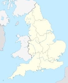
Stourport-on-Severn ist eine Stadt im Distrikt Wyre Forest der britischen Grafschaft Worcestershire am Fluss Stour in der näheren Umgebung von dessen Mündung in den Fluss Severn. Die Volkszählung im Jahr 2001 ergab in der Stadt die Zahl von 19.713 Einwohnern[1].

Die Stadt liegt auch am historischen Staffordshire-Worcestershire-Kanal, der vom Severn bis zum Trent-und-Mersey-Kanal führt und heute lediglich noch touristische Bedeutung hat, aber erhalten blieb, weil er ein geschütztes Denkmal ist.

Inhaltsverzeichnis

Städtepartnerschaft

Partnerstadt von Stourport-on-Severn ist Villeneuve-le-Roi in der französischen Region Île-de-France.

Söhne und Töchter der Stadt

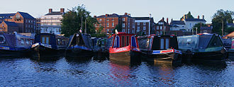
Am Kanal in Stourport

Weblinks

 Commons: Stourport-on-Severn – Sammlung von Bildern, Videos und Audiodateien

Nachweise

  1. Office for National Statistics, Census 2001)

Wikimedia Foundation.

Игры ⚽ Нужно сделать НИР?

Schlagen Sie auch in anderen Wörterbüchern nach:

  • Stourport-on-severn — Stourport on Severn …   Wikipédia en Français

  • Stourport-on-Severn — Stourport on Severn …   Wikipédia en Français

  • Stourport-on-Severn — infobox UK place country = England official name= Stourport on Severn latitude= 52.34182 longitude= 2.27624 population = 19,713 shire district= Wyre Forest shire county = Worcestershire region= West Midlands constituency westminster= Wyre Forest… …   Wikipedia

  • Stourport-on-Severn — Original name in latin Stourport on Severn Name in other language Stourport, Stourport On Severn State code GB Continent/City Europe/London longitude 52.35 latitude 2.26667 altitude 25 Population 19713 Date 2012 03 29 …   Cities with a population over 1000 database

  • Severn Valley Railway — Heritage Railway name = Severn Valley Railway locale = Bewdley, Worcestershire terminus = Bridgnorth, Shropshire linename = Severn Valley Line builtby = Great Western Railway originalgauge = RailGauge|ussg preservedgauge = RailGauge|ussg operator …   Wikipedia

  • Stourport Swifts F.C. — Football club infobox clubname = Stourport Swifts fullname = Stourport Swifts Football Club nickname = Swifts founded = 1882 ground = Walshes Meadow Stourport on Severn Worcestershire capacity = 2,000 (250 seated) chairman = Chris Reynolds… …   Wikipedia

  • Severn Way — The Severn Way [http://www.geograph.org.uk/photo/85902] is a waymarked [http://www.geograph.org.uk/photo/6687] long distance footpath in the United Kingdom following the course of the River Severn [http://www.geograph.org.uk/photo/118846] in the… …   Wikipedia

  • Stourport — (spr. ßtūr pōrt), Stadt in Worcestershire (England), an der Mündung des Stour in den Severn, mit Spinnerei, Teppichweberei und (1901) 4529 Einw …   Meyers Großes Konversations-Lexikon

  • Stourport Ring — The Stourport Ring is a connected series of canals forming a circuit, or canal ring, around Worcestershire, The Black Country and Birmingham in central England. The ring is formed from the River Severn, the Staffordshire and Worcestershire Canal …   Wikipedia

  • Severn, River — Welsh Hafren ancient Sabrina River, eastern Wales and western England. Britain s longest river, it is 180 mi (290 km) long from its source to tidal waters. It rises in east central Wales and crosses the English border near Shrewsbury, continuing… …   Universalium

Share the article and excerpts

Direct link
Do a right-click on the link above
and select “Copy Link”