Tarnica

Tarnica
Tarnica
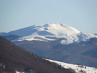
Westansicht der Tarnica (Januar 2008)

Westansicht der Tarnica (Januar 2008)

Höhe 1.346 m
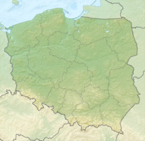
Lage Powiat Bieszczadzki, Woiwodschaft Karpatenvorland, Polen
Gebirge Bieszczady
Schartenhöhe 494 mfd2
Geographische Lage 49° 4′ 29″ N, 22° 43′ 35″ O49.07471666666722.726251346Koordinaten: 49° 4′ 29″ N, 22° 43′ 35″ O
Tarnica (Polen)
Tarnica

Die Tarnica ist mit 1346 m der höchste Berg der polnischen Bieszczady im äußersten Südosten des Landes im Powiat Bieszczadzki der Woiwodschaft Karpatenvorland nahe der Grenze zur Ukraine.

Wanderweg zum Gipfel

Der Gipfel der Tarnica (Tarnica heißt auf Rumänisch Sattel, siehe seine Form) überragt das Tal des Gebirgsflusses Wołosaty um knapp 500 Meter. Von den benachbarten Bergen ist er durch seine Gestalt gut zu unterscheiden. Der Berg hat zwei separate Gipfel, deren einer 1339 und der andere 1346 Meter hoch ist. Der Südhang besteht aus einer steilen Felswand, die gegenüberliegende Seite aus weniger steilen Gras- und Geröllfeldern.

Die Tarnica liegt nahe am Europäischen Fernwanderweg E8 im Bieszczady-Nationalpark und ist von Ustrzyk Górne beziehungsweise von Wołosate aus zu erreichen. In den Bergketten benachbart sind die übrigen höchsten Gipfel der Bieszczady wie der Krzemień (1335 m) und der Halicz (1333 m).

Weblinks

 Commons: Tarnica – Sammlung von Bildern, Videos und Audiodateien

Wikimedia Foundation.

Игры ⚽ Нужно сделать НИР?

Schlagen Sie auch in anderen Wörterbüchern nach:

  • Tarnica — Geobox|Mountain name = Tarnica native name = other name = category = etymology = Its name comes from the west slavic dialect word tarnina , meaning sloe peak nickname = Tarnica image caption = Northern summit country = POL country1 = state =… …   Wikipedia

  • Bieszczady — dep1dep2 Bieszczady Lage Bieszczady …   Deutsch Wikipedia

  • Bieszczady National Park — Infobox protected area | name = Bieszczady National Park native name = Bieszczadzki Park Narodowy iucn category = II caption = Tarnica locator x = locator y = location = Subcarpathian Voivodeship, Poland nearest city = lat degrees = lat minutes …   Wikipedia

  • tarniţă — TÁRNIŢĂ, tarniţe, s.f. 1. Şa (ţărănească) de lemn sau (rar) de piele, folosità la călărit sau la transportul unor poveri. 2. Culme, coamă de munte sau de deal în formă de şa. 3. (reg.) Drum de munte, bătut de oi sau de vite. – ucr. tarnića.… …   Dicționar Român

  • Bieszczady Mountains — See also Bieszczady County and Bieszczady National Park. Geobox| Range name = Bukovské vrchy, Bieszczady native name = other name = en. Bukovec Mountains other name1 = en. Bieszczadzkie Mountains image size = image caption = Location in Slovakia… …   Wikipedia

  • Gmina Niemodlin — Niemodlin Commune   Gmina   …   Wikipedia

  • Poland — Polska redirects here. For other uses, see Polska (disambiguation). This article is about the country. For other uses, see Poland (disambiguation). Republic of Poland Rzeczpospolita Polska …   Wikipedia

  • Red Ruthenia — Ruś czerwona ←   …   Wikipedia

  • Prešov — Geobox | Settlement name = Prešov category = City image caption = City centre of Prešov symbol = etymology = official name = motto = nickname = country = Slovakia country state = region = Prešov district = Prešov municipality = parent = Šariš… …   Wikipedia

  • Dukla — This article is about a town in Poland. For other uses, see Dukla (disambiguation). Dukla Church of the Bernardyni Fathers in Dukla …   Wikipedia

Share the article and excerpts

Direct link
Do a right-click on the link above
and select “Copy Link”