Taunton Stop Line

Taunton Stop Line
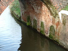
Sprengkammern unter einer Brücke über den Bridgwater-und-Taunton-Kanal

Die Taunton Stop Line war eine britische, während des Zweiten Weltkrieges angelegte Verteidigungslinie im Südwesten England. Dieses Verteidigungssystem verläuft etwa 80 km durch Somerset, Dorset und Devon, in etwa von Axminster nach Chard längs des Flusses Axe, dann längs der Great Western Railway nach Ilminster über Taunton und Bridgwater entlang des Flusses Parret zur Küste nach Highbridge. Diese Verteidigungslinie wurde gegen eine potenzielle deutsche Landung in England errichtet (Operation Seelöwe). Strategisches Ziel der Verteidigungslinie war, einen möglichen schnellen deutschen Vormarsch mit Panzerverbänden von Westen her abzubremsen. Die Stellung bestand aus sogenannten Pillbox-Bunkern.

Galerie

Siehe auch

Weblinks


Wikimedia Foundation.

Игры ⚽ Поможем решить контрольную работу

Schlagen Sie auch in anderen Wörterbüchern nach:

  • Taunton Stop Line — The Taunton Stop Line was a World War II defensive line in southwest England. It was designed to stop an enemy s advance from the west and in particular a rapid advance supported by armoured fighting vehicles (up to the size of a German medium… …   Wikipedia

  • Coquet Stop Line — Pillbox P305 Catheugh Plantation from the south side, obscured by trees planted since the war …   Wikipedia

  • Coquet Stop Line —  Karte mit allen Koordinaten: OSM, Google oder …   Deutsch Wikipedia

  • Tyne Stop Line — Die Tyne Stop Line war eine britische, während des Zweiten Weltkrieges angelegte Verteidigungslinie. Dieses Verteidigungssystem verläuft im Redetal in Northumberland und von dort bis Newcastle upon Tyne. Sie wurde gegen eine potenzielle deutsche… …   Deutsch Wikipedia

  • Taunton (disambiguation) — Taunton is the county town of Somerset. It may also refer to: *Taunton Deane, a local government district with borough status in Somerset.PlacesOther places in Great Britain: *Taunton Stop Line, a World War II defensive line in south west England …   Wikipedia

  • Taunton — infobox UK place country = England latitude= 51.0191 longitude= 3.1000 official name= Taunton population = 88,241 shire district= Taunton Deane shire county = Somerset region= South West England Ambulance= South Western constituency westminster=… …   Wikipedia

  • Taunton (Begriffsklärung) — Es gibt folgende Orte Namens Taunton: Taunton in Somerset, England Taunton (Massachusetts) in den USA Taunton (Minnesota) in den USA Taunton (New York) in den USA Außerdem gibt es: den Taunton National Park in Queensland, Australien den… …   Deutsch Wikipedia

  • Chard Branch Line — The bridge over the River Tone at Creech St Michael Overview Type Cross country …   Wikipedia

  • Bridgwater and Taunton Canal — The Bridgwater and Taunton Canal is a canal in the south west of England between Bridgwater and Taunton, linking with the River Parrett and the River Tone. It was originally intended that the canal should extend across the south western peninsula …   Wikipedia

  • GHQ Line — The GHQ Line (General Headquarters Line) was a defence line built in the United Kingdom during World War II to contain an expected German invasion. The British Army had abandoned most of its equipment in France after the Dunkirk evacuation. It… …   Wikipedia

Share the article and excerpts

Direct link
Do a right-click on the link above
and select “Copy Link”