Trout Beck

Trout Beck
Trout Beck
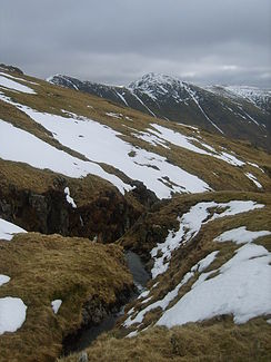
Der Trout Beck nahe seinem Ursprung

Der Trout Beck nahe seinem UrsprungVorlage:Infobox Fluss/KARTE_fehlt

DatenVorlage:Infobox Fluss/GKZ_fehlt
Lage Cumbria, England
Flusssystem Leven
Flussgebietseinheit North West
Entstehung Südhang von Stony Cove Pike
54° 28′ 51″ N, 2° 54′ 4″ W54.48081-2.901134
Vorlage:Infobox Fluss/QUELLHÖHE_fehlt
Mündung in den Windermere See
54.388105-2.933707

54° 23′ 17″ N, 2° 56′ 1″ W54.388105-2.933707
Vorlage:Infobox Fluss/MÜNDUNGSHÖHE_fehltVorlage:Infobox Fluss/HÖHENUNTERSCHIED_fehlt
Länge 11 kmVorlage:Infobox Fluss/NACHWEISE_fehlenVorlage:Infobox Fluss/EINZUGSGEBIET_fehlt

Vorlage:Infobox Fluss/ABFLUSS_fehlt

Rechte Nebenflüsse Woundale Beck
Linke Nebenflüsse Hagg Gill
Gemeinden Troutbeck (South Lakeland)

Der Trout Beck ist ein Fluss im Lake District in Cumbria, England. Der Trout Beck entsteht an den südlichen Hängen unterhalb des Stony Cove Pike. Der Fluss mündet nach 11 km nördlich des Ortes Windermere in den Windermere See. Der Fluss war bis 1974 in seiner ganzen Länge in Westmorland, er liegt heute aber vollständig in Cumbria.

Der Trout Beck fließt von seiner Entstehung in südlicher Richtung; er fließt durch ein enges Tal östlich des Ortes Troutbeck und westlich der Troutbeck Tongue. Der Hagg Gill und der Woundale Beck sind seine zwei größten Zuflüsse zu denen noch eine ganze Reihe kleiner unbenannter Bäche kommen.


Wikimedia Foundation.

Игры ⚽ Поможем сделать НИР

Schlagen Sie auch in anderen Wörterbüchern nach:

  • Trout Beck — The Trout Beck is a fast flowing river of the Lake District in north west England. It is one of the main sources of replenishment for Windermere. Its name comes from Old Norse and appears in documents from 1292 as Trutebyk . The river rises… …   Wikipedia

  • Trout — On the face of it, this interesting English medieval surname is an occupational nickname for a man who either operated a trout farm, all monasteries and most major houses would have had a designated trout lake, or one who was a renowned trout… …   Surnames reference

  • Woundale Beck — Woundale BeckVorlage:Infobox Fluss/GKZ fehlt Lage Cumbria, England Flusssystem Leven Flussgebietseinheit North West …   Deutsch Wikipedia

  • Cunsey Beck — is one of several rivers and streams that replenish the lake of Windermere in the English Lake District. Being just over two miles (3.2 km) in length and generally slow flowing, the stream descends some 87 feet (27 m) from the southern end… …   Wikipedia

  • Cock Beck — Coordinates: 53°49′59″N 1°25′52″W / 53.833°N 1.431°W / 53.833; 1.431 …   Wikipedia

  • Costa Beck — Coordinates: 54°15′22″N 0°47′38″W / 54.256°N 0.794°W / 54.256; 0.794 Costa Beck is a small river in the …   Wikipedia

  • Killington Beck — is a stream or in Cumbria, England about 15 km long. It starts at a height of about 300 m on Lambrigg Fell between Kendal and Sedbergh.About one kilometre from its source it is dammed and forms the Killington Reservoir or Killington Lake. This… …   Wikipedia

  • Driffield Beck — Coordinates: 54°00′11″N 0°25′34″W / 54.003°N 0.426°W / 54.003; 0.426 Driffield Beck, East Riding of Yorkshi …   Wikipedia

  • Windermere — Infobox lake lake name = Windermere image lake = Lake windermere in 2005.jpg caption lake = from the north image bathymetry = caption bathymetry = location = Lake District National Park coords = coord|54|21|30|N|2|56|10|W|region:GB… …   Wikipedia

  • River Rothay — The Rothay is a spate river of the Lake District in north west England. Its name comes from Old Norse and translates literally as the red one . This has come to mean trout river . It rises close to Rough Crag above Dunmail Raise at a point about… …   Wikipedia

Share the article and excerpts

Direct link
Do a right-click on the link above
and select “Copy Link”